When can We Expect our Last Spring Frost in Missouri?
Pat Guinan
State Climatologist
Commercial Agriculture/University of Missouri Extension
During April, winter becomes less of an experience and more of a memory. With the return of warmer weather, a lot of us are ready to venture outdoors and tend to our gardens or rev up the tractor and contemplate planting. When it comes to springtime planting in the garden and field, however, we must be careful not to start too early. A warm spell in March or early April does not guarantee the end of freezing temperatures for the rest of the season. If you know when the average date of the last spring frost is for your area, and you have a good idea of how topography can affect temperature, you can use that knowledge in deciding when may be a safe time to plant and avoid freeze injury.
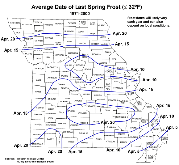
The following map displays the average date of the last spring frost (≤32°F) in Missouri. These are dates in the spring after which there is a 50 percent chance of a light killing frost. Typically, the last spring frost occurs over northern and central Missouri by April 20 and April 10, respectively. Frosts are more likely to be experienced later in the spring over the Ozarks when compared to central Missouri. The reason for this is due to the higher elevation of the Ozark Plateau which causes cooler temperatures in the Ozark region than would be expected. In fact, some counties in the Ozarks normally do not experience their last frost until the end of April. As the Ozark Plateau transitions to the southeastern lowlands of the bootheel, the average last spring frost retreats to the beginning of the month. Portions of the Bootheel normally receive their last killing frost during the first week of April.
Another item to consider is local terrain. Temperatures can be highly variable within small distances due to topography and this map is only a generalized view of expected last spring frost dates. Minimum temperatures can vary as much as 10° F over a short distance, say, from the bottom of a valley to a nearby hilltop. Cool air, being more dense than warm air, moves down the slopes of hills, accumulating in the valleys. This is why low lying areas, such as river bottoms, will likely be colder than their surroundings on clear, calm nights. Therefore, while referring to this map, consider your local landscape when making your planting decisions.