March 2012 Weather and Its Impacts on Missouri
March Madness - a historic month
Pat Guinan
State Climatologist
Commercial Agriculture/University of Missouri Extension
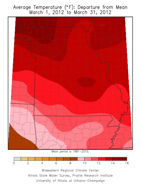
A highly unusual and stagnant warm weather pattern impacted a large area of the United States in March, generally from the Rocky Mountains eastward to the Atlantic seaboard (Figure 1). An area of low pressure remained parked over the Pacific Northwest while an area of high pressure spun clockwise off the Atlantic coast. Gulf of Mexico air was consistently pumped into the heart of the country on southerly wind flow that lasted for days, while the polar jet stream remained locked over Canada, preventing arctic air from spilling into the region.
More than 7,700 daily high temperature records were set during the month and preliminary data are indicating it may surpass the previous warmest March on record for the U.S., which occurred in 1910.
According to the Midwestern Regional Climate Center, based in Champaign, IL, nine Midwestern states experienced their warmest March ever: Illinois, Indiana, Iowa, Kentucky, Michigan, Minnesota, Missouri, Ohio, and Wisconsin.
Preliminary data indicate Missouri's statewide average March temperature was 57.8°F, or 13.1 degrees above normal, ranking it the highest above normal monthly temperature departure for any month in Missouri, since 1895. Monthly double digit departures above normal occur rarely in the Show Me state, having occurred only 5 times since 1895:
|
Year |
Month |
Average Temp (°F) |
Dept. from Normal (°F) |
1910 |
March |
55.0 |
+10.2 |
1933 |
January |
40.7 |
+10.3 |
1963 |
October |
66.7 |
+10.6 |
2006 |
January |
41.2 |
+10.7 |
2012 |
March |
57.8 |
+13.1 |
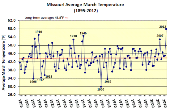
Figure 2 shows the magnitude of warmth in Missouri, when compared to Marches in the past, surpassing the previous record, set back in 1910, by nearly 3 degrees. March 2012 also exceeded temperature norms for April in Missouri, averaging 2.7 degrees above the average temperature for April.
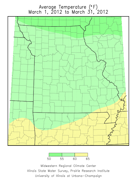
Regionally, average March temperatures were in the mid 50's across northern Missouri, and upper 50's and lower 60's across central and southern sections. There were many locations across the state where more than half the days experienced high temperatures in the 70's and 80's during the month. Additionally, numerous high maximum and high minimum temperature records were broken. Minimum temperatures remained above freezing in most areas of the state beginning March 11th through the end of the month.
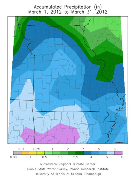
Several significant rainfall events occurred during the month and translated to above normal precipitation for much of the state. The statewide average total was 4.18 inches, or a little less than an inch above normal. Regionally, heaviest amounts fell over west central, southwestern and south central Missouri where 5-7 inches were common. Heaviest amounts were reported in Ozark, Douglas and Newton counties where 9.19, 8.53 and 8.13 inches were observed, respectively. Lighter monthly totals, ranging from 3-5 inches, were common across the rest of the state, with the exception of some northern and eastern border counties where less than 3 inches were observed. Far northeastern counties reported the driest conditions where CoCoRaHS observers in Lewis, Pike and Clark counties reported 1.54, 1.31, and 1.14 inches, respectively, for the month.
Unprecedented warmth and sufficient moisture led to an exceptionally early start to the growing season in March. Vegetative growth was running 3-4 weeks ahead of normal and creating significant concern for agricultural and horticultural interests. By the end of March, numerous plants were at growth stages vulnerable to freezing temperatures. Though not widespread, there were also reports of some corn planting occurring in northern and central parts of the state during the last two weeks of the month.
Using historical temperature records, the average last spring frost date is defined as the day after which there is a 50 percent chance of a light killing frost (≤ 32°F). Typically, the last spring frost occurs over northern and central Missouri by April 20 and April 10, respectively. Frosts are more likely to be experienced later in the spring over the Ozarks when compared to central Missouri. The reason for this is due to the higher elevation of the Ozark Plateau which causes cooler temperatures in the Ozark region than would be expected. In fact, some counties in the Ozarks normally do not experience their last frost until the end of April. As the Ozark Plateau transitions to the southeastern lowlands of the Bootheel, the average last spring frost retreats to the first week of April.
The average date for the last moderate freeze (24-28°F) ranges from the last 10 days of March in the Bootheel to the first week of April across most of southern and central sections, to early into the second week of April over northern Missouri.
Figure 1:
Average Temperature (°F) Departure from
Mean March 1, 2012 to March 31, 2012
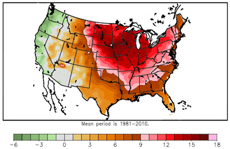
Figure 2: |
 |