
March 2014 Weather and Its Impacts on Missouri
Pat Guinan
State Climatologist
Commercial Agriculture/University of Missouri Extension
Below temperatures dominated during March, continuing the theme of cooler than normal weather for the past 13 months, Figure 1. Since March of last year, only September has averaged above normal. The April 2013 through March 2014 period ranks as the 7th coolest on record, Figure 2.
Preliminary data indicate the statewide average temperature for March was 39.0°F, or 4.7°F below the long-term normal. Record cold temperatures were experienced during the first week of the month with much of northern Missouri dropping below zero on the 2ndand 3rd, and central Missouri on the 3rd of the month, both unusual occurrences. Some locations across northern Missouri observed low temperatures on the 3rd between -10°F and -13°F, a rare occurrence for March. Another rarity was the high temperatures on March 2 across northern Missouri, hovering slightly above zero for much of the day. With temperature data since 1889, Kansas City established an all-time coldest maximum temperature for March when the mercury climbed to 5°F on the 2nd, smashing the previous record of 11°F established on March 4, 1978. Above normal temperatures were rare during the month with only a few days climbing into the 70's, Figure 3. Preliminary data indicate March 2014 ranked as the 22ndcoldest March on record, Figure 4.
March precipitation averaged below normal with preliminary data indicating a statewide average of 1.97 inches, or 1.3 inches below the long-term normal. It was the third consecutive month with below normal precipitation, Figure 5. Heaviest precipitation fell across southern sections where 2-4 inches were common. Highest totals were confined to the Bootheel where Kennett and Caruthersville reported 4.62 inches and 4.94 inches, respectively. One to two inches were common over north central, northeast and central Missouri, with less than an inch observed across northwestern sections. Lightest amounts fell across the northwestern tip where Mound City and Rock Port reported 0.24 inches and 0.17 inches, respectively.
The most notable winter event for the month came on the heels of an arctic blast when 3-6 inches of a snow/sleet mixture impacted much of northern Missouri on March 1-2, Figure 6. The same storm system dropped 3-6 inches of snow across portions of southern Missouri, Figure 7. Far southeastern Missouri also received 3-6 inches of snow, with most in the form of sleet. It took many days to melt the thick ice accumulation covering the ground. Another snow/sleet event impacted southern sections on March 16-17 with 1-3 inches reported.
The cool month limited severe weather opportunities, but on March 27 severe thunderstorms developed across western Missouri with several reports of large hail, strong winds and tornadoes, Figure 8. The National Weather Service documented 3 tornadoes in northwestern Missouri, impacting Daviess and Grundy counties. According to the survey, structures sustained significant damage near Jameson, MO and residences were damaged in and around Tindall, MO. One tornado was rated at EF-1 (86-110 mph) and two tornadoes were rated EF-2 (111-135 mph). Figures 9, 10, and 11 are pictures taken of the supercell thunderstorm that spawned the tornadoes.
Dry conditions continued to intensify across much of the state with moderate drought impacting extreme northwestern sections and portions of central Missouri by the end of the March, Figure 12. Long-term water deficits continued to accumulate and were exceeding 10 inches over parts of northern and central Missouri since July 1, 2013.
The median last spring frost date is defined as the day after which there is a 50 percent chance of a light killing frost (≤ 32°F). Typically, the last spring frost occurs over northern and central Missouri by April 20 and April 10, respectively. Frosts are more likely to be experienced later in the spring over the Ozarks when compared to central Missouri. The reason for this is due to the higher elevation of the Ozark Plateau which causes cooler temperatures in the Ozark region than would be expected. In fact, some counties in the Ozarks normally do not experience their last frost until the end of April. As the Ozark Plateau transitions to the southeastern lowlands of the Bootheel, the median last spring frost retreats to the first week of April.
Jump to:
- Figure 1
- Figure 2
- Figure 3
- Figure 4
- Figure 5
- Figure 6
- Figure 7
- Figure 8
- Figure 9
- Figure 10
- Figure 11
- Figure 12
- Figure 13
- Figure 14
- Figure 15
- Figure 16
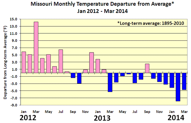
Figure 1
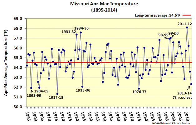
Figure 2
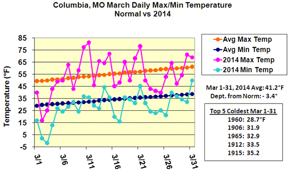
Figure 3

Figure 4.
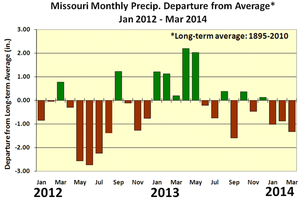
Figure 5
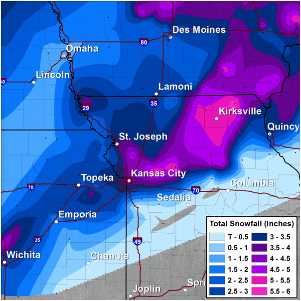
Figure 6. March 1-2, 2014 snowfall map. Source: NWS Forecast Office, Pleasant Hill, MO
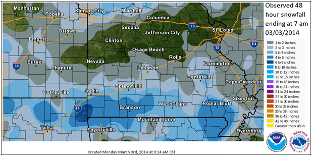
Figure 7. March 2-3, 2014 snowfall map. Source: NWS Forecast Office, Springfield, MO
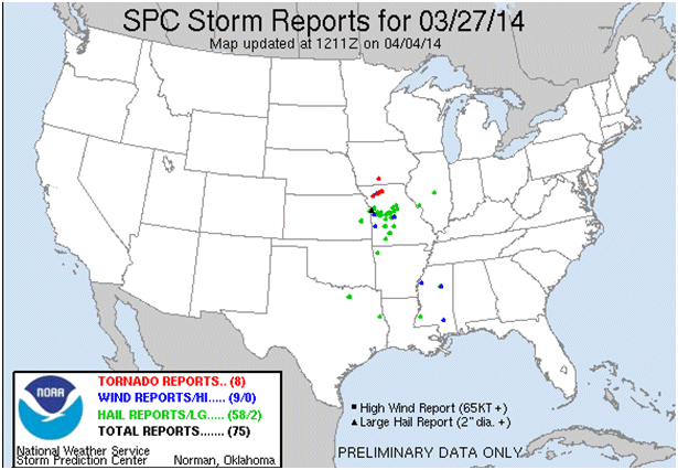
Figure 8. Storm reports for March 27, 2014. Source: NWS/Storm Prediction Center
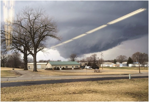
Figure 9. Looking west-northwest of Trenton, MO just before damaging houses and barns north of Trenton. Photo credit: Kabel Oaks
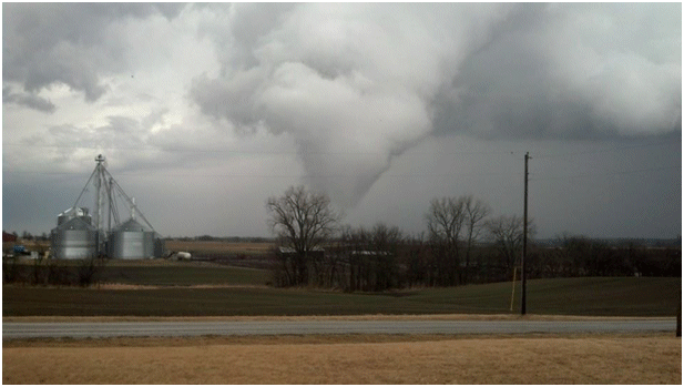
Figure 10. Near Trenton, MO. Photo credit: Ethan George
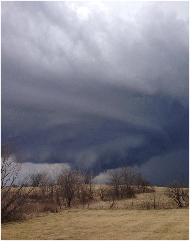
Figure 11. Near Trenton, MO. Photo credit: Amy Madden
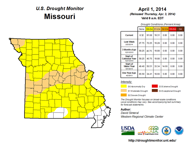
Figure 12. Drought Monitor map for April 1, 2014
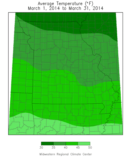
Figure 13.
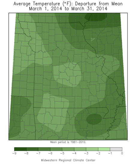
Figure 14.
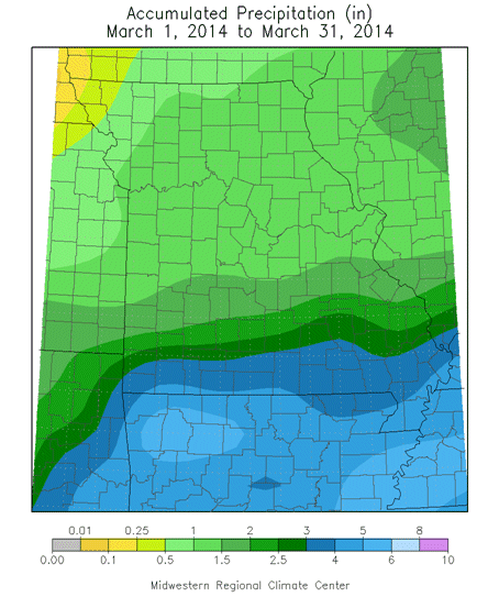
Figure 15.
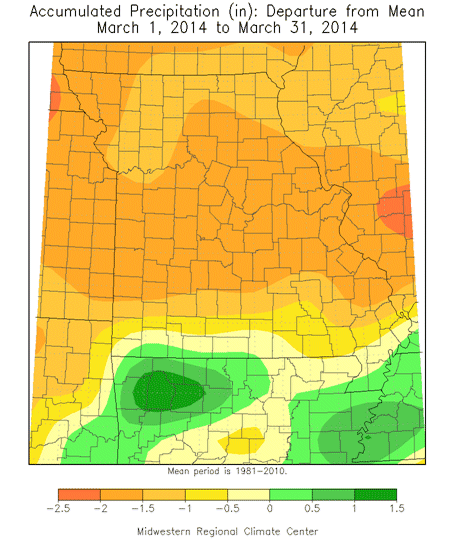
Figure 16.
Source: Pat Guinan, 573-882-5908