
March 2017 Weather and Its Impacts on Missouri
Pat Guinan
State Climatologist
Commercial Agriculture/University of Missouri Extension
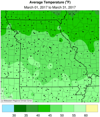
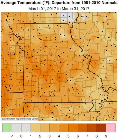
Mild weather dominated the Show Me State during March, but not near the level of unprecedented warmth experienced in February. A cold period during the second week tempered the overall monthly average, Figure 1. Preliminary March data indicate an average statewide temperature of 47.8°, or slightly more than 4 degrees above normal. There have only been 10 cooler than average Marches since 1985, Figure 2. An incredible warm trend has prevailed since the fall of 2015, with only 2 out of the past 19 months averaging below normal, Figure 3.
Record February warmth and mild conditions during the first week of March spurred some vegetation to come out of dormancy at an unusually early time of year, leaving some plants vulnerable to freezing weather. Unfortunately, the scenario played out by mid-March when a cold blast brought sub-freezing temperatures to the region. The coldest morning occurred on March 15 with most locations reporting minimum temperatures between 10-20°F. A few locations across northern Missouri reported single digit minimums. Early blooming tree and shrub species such as magnolias, quince, forsythia etc. experienced freeze impacts, Figure 4.
A freeze impact report on March 27 from Dr. Michele Warmund, University of Missouri Extension Fruit Crop Professor, stated "some locations in west central Missouri had 100% mortality on full blooming apricots and plums. There was about 40% flower loss on Redhaven peach, but a full crop was still anticipated with thinning of flowers. More flower loss had likely occurred on earlier-blooming peaches, and less damage to late-blooming cultivars. Depending on location, where temperatures were colder in low-lying areas, there was likely more flower damage. However, a crop of peaches was still anticipated since they only need about 10% of flowers for a full crop. Apples appear to have escaped freeze damage since they were not blooming at the time."
Another freeze impact report from southwestern Missouri by Patrick Byers, Extension Horticulture Specialist, indicated "heavy damage to plums and apricots, with variable peach and pear damage. Many peach trees, however, were expected to have a marketable crop. Apple damage appeared to be minor. Early flowering blueberries had minor damage, while those still in tight bud during the freeze appear to have escaped damage. Protected strawberries suffered minor to moderate damage."
A guide to spring frost/freeze probabilities for Missouri can be accessed at the following link:
Missouri Frost Freeze Probabilities Guide
http://ipm.missouri.edu/frostfreezeguide/
March roared in like a lion with severe thunderstorms and tornadoes impacting portions of southern Missouri during the early morning hours of March 1. It was part of 2-day outbreak of severe weather that began at the end of February. Two tornadoes in southwestern Missouri on March 1, one in Dallas county (EF-0), the other in Laclede county (EF-1), were reported between midnight and 1 a.m. Tree and property damage were reported. Later that morning, between 4:40-4:52 a.m., a tornado touched down 4 miles south-southeast of Sikeston, MO and, according to a NWS survey, traveled on the ground for 15.3 miles before lifting 3 miles north-northeast of Anniston, MO. Property and tree damage were reported, including damage to utility poles and irrigation systems. A Missouri Mesonet weather station located at the Mississippi county Airport, south of Charleston, MO, was within a few hundred yards of the tornados' direct path and recorded a wind gust of 72.0 mph at 4:43 a.m. CST. An EF-1 tornado was reported in Dent county late in the evening on March 29.
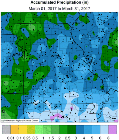
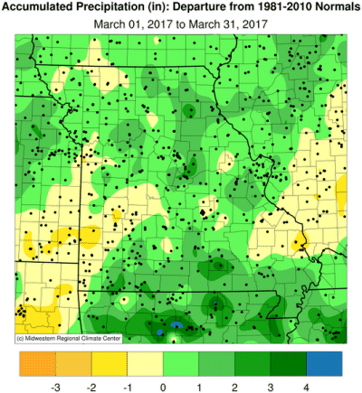
A wet pattern emerged during March, ending an extended multi-month dry spell that began last October, Figure 5. Preliminary data indicate a statewide monthly average total of 3.9 inches, 0.6 inches above the long-term average. It was the first wetter than average March since 2013, Figure 6. Most areas of the state received 3-5 inches during the month with heavier totals, 5-6 inches, reported over far southern sections. Lighter amounts, 2-3 inches, were reported over portions of northwestern Missouri, with similar totals occurring in an area extending from Kansas City southward to Joplin. No heavy snow events occurred during the month.
Jump to:
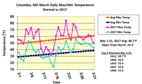
Figure 1.
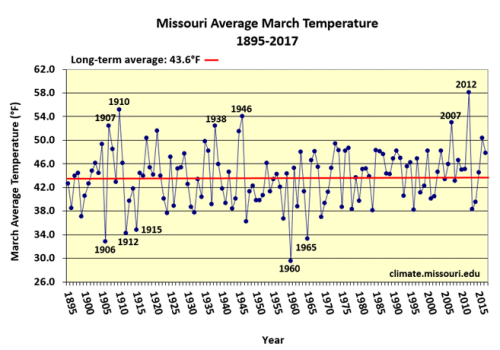
Figure 2.
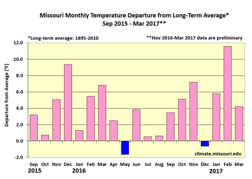
Figure 3.
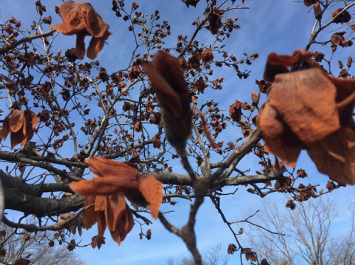
Freeze damage to Magnolia blossoms in Columbia, MO, Mar 15, 2017. Photo: P. Guinan
Figure 4.
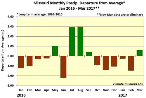
Figure 5.
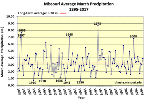
Figure 6.
Source: Pat Guinan, 573-882-5908