July 2012 Weather and Its Impacts on Missouri
Pat Guinan
State Climatologist
Commercial Agriculture/University of Missouri Extension
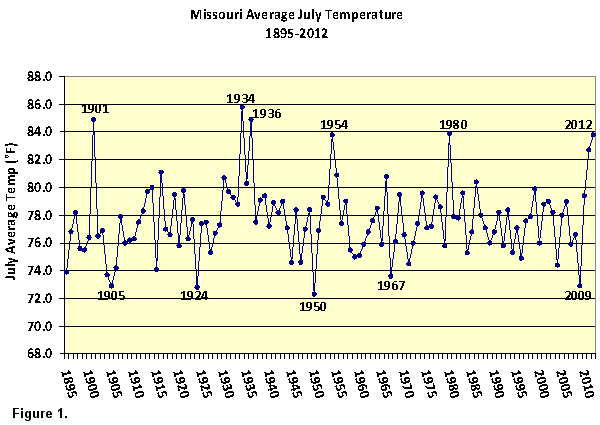
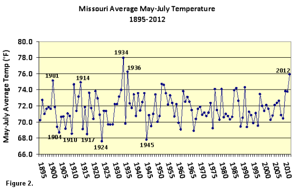
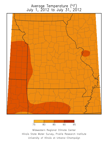
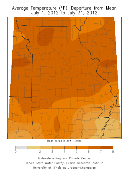
Unrelenting dryness and extreme heat persisted through July, in what has become a historic drought and heat event for much of the 2012 growing season. Preliminary data indicate this month will rank as the hottest July since 1980, and tie with 1954 to be the 5th hottest July on record (Figure 1). The average statewide temperature for the month was 83.8°F, or 6.5° above normal. The statewide average temperature for May through July was 75.9°F, and ranks as the third warmest May-July period on record, and the warmest since 1936 (Figure 2).
Numerous days with triple digit heat produced uncomfortable and life threatening conditions during the month. There were lengthy and continuous periods of various heat advisories and warnings impacting the state and, unfortunately, heat related fatalities were reported. The Missouri Department of Health and Senior Services reported 28 heat related fatalities for by the end of the month. The majority of deaths occurred in the St. Louis metropolitan area, where 23 fatalities were reported. The Kansas City metro area reported 3 deaths. As of July 31, Columbia, Kansas City, St. Louis, and Springfield reported 20, 19, 18, and 14 days, respectively, with triple digit heat for the year.
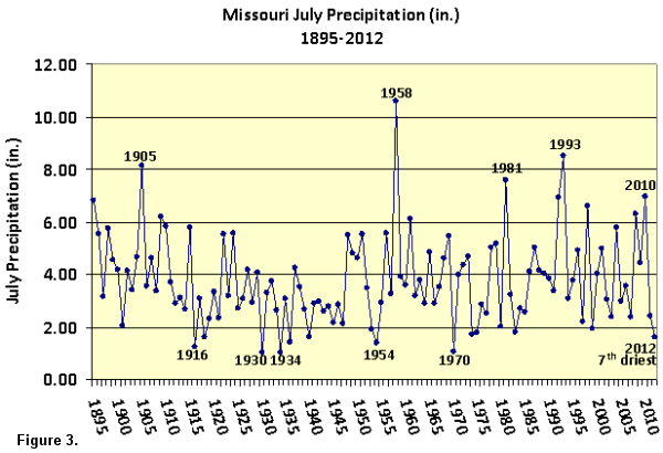
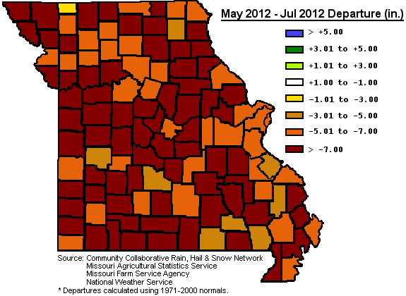
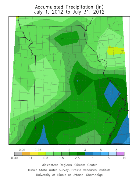
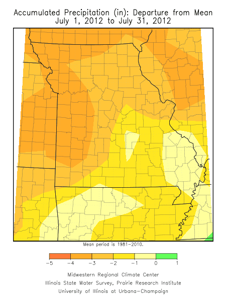
July precipitation totals were grim for the state, with data indicating a statewide average precipitation of 1.61 inches, or 2.63 inches below normal for the month. It was the 7th driest July on record, and the driest July since 1970 (Figure 3). Generally, west central and southwestern Missouri received the least amount of rain, with less than 0.5 inches reported in many locations. Several counties in far southwestern Missouri reported less than 0.25 inches for the month. Some localized and scattered thunderstorm events brought heavier rainfall to other areas of the state, including parts of south central, southeast and north central Missouri where 2-4 inches were reported.
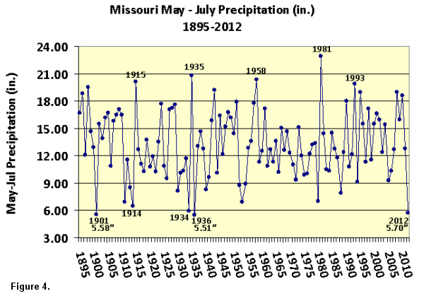
More telling of the intensity and severity of the drought are the temperature and precipitation statistics since May 1 for Missouri. Early stages of statewide drought began to emerge in May and persisted through the end of July. Each month, since May, has ranked in the Top 10 driest on record: 8th driest May; 6th driest June and 7th driest July. Combined, these months rank as the 3rd driest May-July period on record, and the driest in nearly 80 years (Figure 4). Only 1901, 1914, 1934 and 1936 are comparable in regard to the magnitude and severity of the dryness and heat witnessed in 2012.
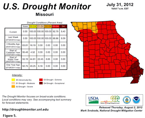
According to the Drought Monitor map, all of Missouri was in severe to exceptional drought by the end of July (Figure 5). Numerous impacts were occurring including widespread crop and pasture losses, livestock stress, and declining stock water and hay supplies. Hydrological issues such as dry wells and stream beds, low river levels, and rural and urban water restrictions were increasingly common. Even with burn bans in place, grassfires and forest fires continued. The extreme conditions were adversely affecting gardens, lawns, trees and shrubs with numerous instances of vulnerable species succumbing to water and heat stress. Wildlife was impacted by the lack of healthy vegetation and dwindling water resources. With no significant relief anticipated for August, additional impacts, some perhaps unknown, will continue to emerge.
By the end of July, and according to the National Agricultural Statistics Service, Missouri had the dubious distinction of having the worst corn, soybean and pasture conditions in the United States. Corn, soybean and pastures were reported to be in 83%, 72%, and 98% poor to very poor condition, respectively. Soil moisture reserves were abysmal with 99% of the topsoil and subsoil reported in short to very short condition. Hay and stock water supplies were well below normal and reported to be in 86% and 91% short to very short condition, respectively.
Unfortunately, temperature and precipitation outlooks for August indicate no breakdown of the hot, dry weather pattern. Above normal temperatures and below normal rainfall are forecast for the state by the Climate Prediction Center. Any opportunity for a major weather pattern change, and an improvement in the situation, may not occur until the fall season. Autumn will provide opportunities for recharging water resources above and below the ground, as day length shortens, temperatures cool and vegetation becomes dormant. There have been occasions, in late summer and fall, when remnants of tropical systems brought widespread and significant rainfall to Missouri.