December 2011 Weather and
Its Impacts on Missouri
Pat Guinan
State Climatologist
Commercial Agriculture/University of Missouri Extension
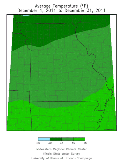
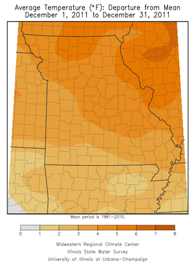
Meteorological winter got off to a mild and wet start across the Show Me State with temperatures averaging 4 degrees above normal and precipitation around 1-inch above normal for the month of December. Preliminary data indicate the statewide average temperature was 37.3°F with regional average temperatures ranging from 34-36°F across northern Missouri, 37-39°F in central sections and 39-42°F across the south.
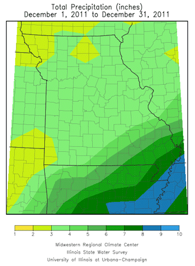
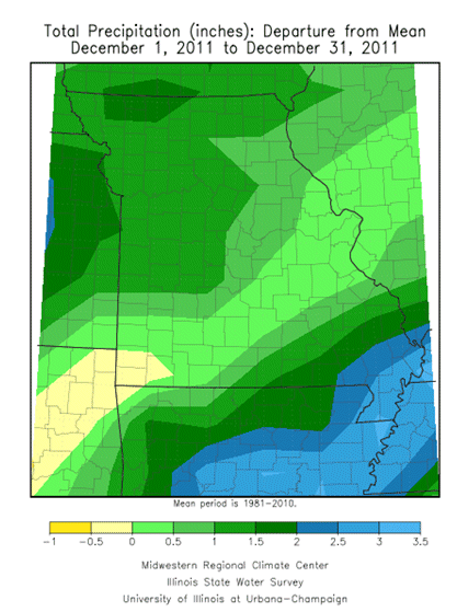
Precipitation was variable, but, with the exception of extreme southwestern Missouri, was above normal statewide, ranging from 2-3 inches across northern Missouri, 3-4 inches across central and southwestern sections, and 4-6 falling southeast of a line from St. Genevieve to Branson. A few counties in extreme southwestern sections reported slightly below normal rainfall with 2.5-3 inches. Heaviest December totals were confined to the Missouri Bootheel where amounts ranged between 6-8 inches. The heaviest precipitation was reported in New Madrid, Caruthersville and Kennett with 8.53, 9.35, and 9.50 inches, respectively. It was the wettest November-December period in the Bootheel since 1957.
The dominant upper weather pattern was a southwesterly flow with frontal boundaries and cutoff lows moving through the region. These low pressure disturbances induced numerous widespread and significant precipitation events across the Show Me State, generally on a weekly basis. The dominant seasonably mild conditions, and absence of arctic air, left little opportunity for snow or ice to impact the area.
A couple of exceptions to this include a light snow event of 1-2 inches impacting mid-Missouri during the morning of December 6th. Even though the snow was light, it was the first measureable snow of the season and occurred during rush hour traffic. Nearly 200 vehicle accidents were reported in Boone county, and some roads in and around Columbia were closed due to numerous accidents on icy roads. Another snow event impacted portions of northern Missouri on the 8th and 9th with 1-2 inches. Lastly, a 75-mile wide band of 1-2 inches of snow affected portions of southeastern and east central Missouri, from Shannon county to St. Louis county, during the overnight hours on December 26-27. Additional significant precipitation events, mostly in the form of rain, occurred in Missouri on December 3-5, 13-15, 19-20 and 26-27.
With the exception of the Bootheel, warmest temperatures for the month occurred on New Year's Eve. Unusually mild conditions rounded out the year, with highs in the lower and middle 60's reported across much of the state. Minimum temperatures remained well above zero for the entire month statewide.
The numerous rain events, in combination with unfrozen soils, acted to help recharge the soil profile and mitigate lingering drought affecting portions of northern and western Missouri. However, additional soil moisture recharge over southwestern sections is needed to completely offset the summer and fall drought that impacted the area. According to the Drought Monitor map, for the week ending December 27th, 2011, abnormally dry conditions were still depicted for portions of extreme southwestern Missouri.
Numerous benefits were derived from the mild weather regime including reductions in heating demand for housing, businesses and farm facilities. Additionally, transportation costs associated with snow plowing, salting, and sanding were minimal and hazardous travel conditions were minimal. Muddy conditions prevailed but, in general, construction activities flourished and digging opportunities were unhindered due to no frost line in the soil. Exposed livestock also benefited from the mild weather.