
November 2018 Weather and Its Impacts on Missouri
Pat Guinan
State Climatologist
University of Missouri Extension
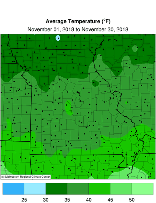
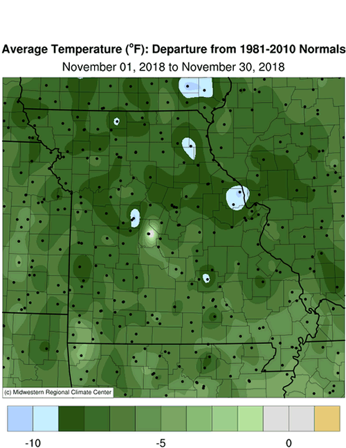
A cold weather pattern began during the second week of October and persisted into November, Figure 1. These conditions dominated for much of the month and preliminary data indicate it was the coldest November since 1976, Figure 2. The average statewide temperature was 37.3�F, 6.5 degrees below the long-term average, Figure 3. It was Missouri�s 4th coldest November on record, Table 1.
| Missouri Top 10 Coldest Novembers Period of record: 1895-2018 | |||
| Rank | Year |
Average Temp. (�F) |
|
| 1 | 1976 | 36.3 | |
| 2 | 1951 | 36.9 | |
| 3 | 1959 | 37.2 | |
| 4 | 2018 | 37.3* | |
| 5 | 2014 | 37.8 | |
| 5 | 1911 | 37.8 | |
| 7 | 1929 | 37.9 | |
| 8 | 1996 | 38.1 | |
| 9 | 1932 | 38.2 | |
| 10 | 1950 | 38.5 | |
| *Preliminary data | |||
| Table 1. | |||
Temperatures were below normal for much of the month, with only a few days managing to climb above 60�F. The warmest temperature occurred on November 22, Thanksgiving Day. A broad upper level trough extended from Canada into much of the country during November, bringing arctic air masses into the region and cold temperatures, more than 10 degrees below normal for several days. Many locations, especially across northern Missouri, reported single digit minimum temperatures on the 10th, 13th, 14th and 27th of the month.
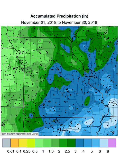
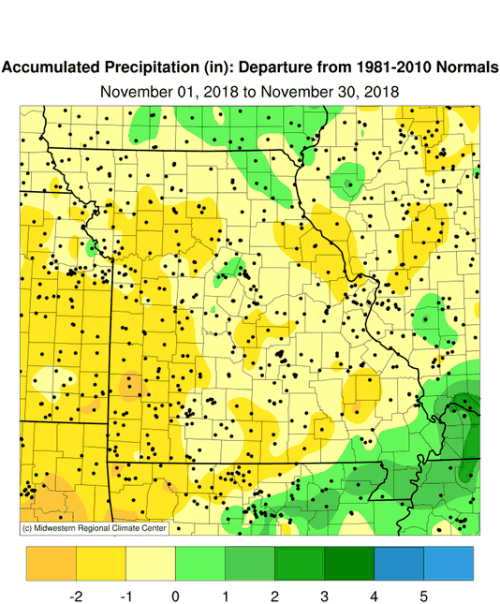
Preliminary precipitation data indicate an average statewide total of 2.66 inches, slightly below the long-term average of 2.89 inches, Figure 4. It was the third consecutive November with below average precipitation, Figure 5. Lightest amounts occurred over northwestern Missouri, where less than 1.5 inches were common. Heavier totals of 3 or more inches were typical over east central, south central and southeastern Missouri. Parts of far southeastern Missouri reported 4-6 inches.
The cold November conditions brought snow with it, and translated to one of the snowiest Novembers in decades, Figure 6. Five separate snow events impacted parts of the state and monthly accumulations of 5-10 inches were common across the northern 2/3 of Missouri, Figure 7. Some of the heaviest monthly totals are listed in Table 2.
| Missouri November 2018 Snowfall | |||
| Station Name* | County |
Snowfall (in.) | |
| Conception Junction 0.3SE | Nodaway | 15.5 | |
| Tarkio #2 | Atchison | 13.9 | |
| Elm | Johnson | 12.6 | |
| Marthasville 12.7N | Worth | 12.5 | |
| Amity 4NE | DeKalb | 12.5 | |
| Rosebud | Gasconade | 12.3 | |
| Steffenville | Lewis | 11.8 | |
| Hermann 3S | Gasconade | 11.5 | |
| New Haven 8.3SSE | Franklin | 10.9 | |
| Josephville 1.1S | St. Charles | 10.9 | |
| *NWS Cooperative Network or CoCoRaHS Network | |||
| Table 2. | |||
A heavy snow event impacted east central Missouri on Nov 14-15 with 4-7 inches reported in and around the St. Louis metropolitan area, Figure 8.
The biggest snow event was a highly unusual November blizzard that impacted the state on November 25-26. Blizzard warnings were issued by the National Weather Service and extended from Kansas to Illinois, Figure 9. Hazardous driving conditions rapidly developed on November 25, with heavy snow and strong winds. Portions of northwestern Missouri experienced wind gusts over 50 mph. The Kansas City International Airport recorded a wind gust of 55 mph. The extreme winds created whiteout conditions, severe drifting and closed roads in some areas. Much of northern Missouri received 4-8 inches of snow during the event, Figure 10.
Drought conditions continued to the improve with only a few pockets of dryness noted in the western half of the state, where surface water supplies had not fully recovered from the long-term dryness, Figure 11. The extended cold minimized evaporative demand and some area ponds had a thin layer of ice during the coldest periods. The cold weather also led to higher energy use among consumers.
As of November 25th, the Missouri Agricultural Statistics Service reported 72% of the topsoil moisture supplies were in adequate condition statewide, and 82% of the subsoil moisture supply as adequate. Winter wheat was reported to be 72% emerged, 10 percentage points lower than the 5-year average, and 57% in good to excellent condition. The majority of hay supplies and other roughages, 71%, were reported short to very short, whereas 82% of stock water supplies were adequate statewide.
Jump to:
- Figure 1
- Figure 2
- Figure 3
- Figure 4
- Figure 5
- Figure 6
- Figure 7
- Figure 8
- Figure 9
- Figure 10
- Figure 11
- Figure 12
- Figure 13
- Figure 14
- Figure 15
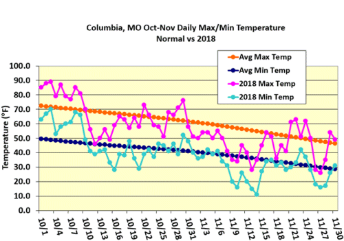
Figure 1.
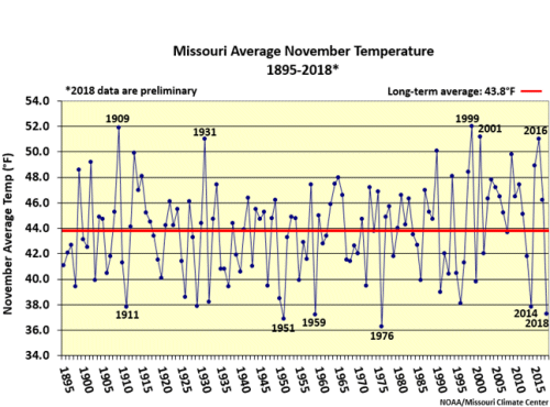
Figure 2.
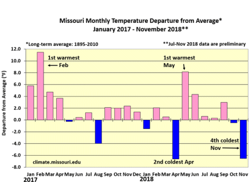
Figure 3.
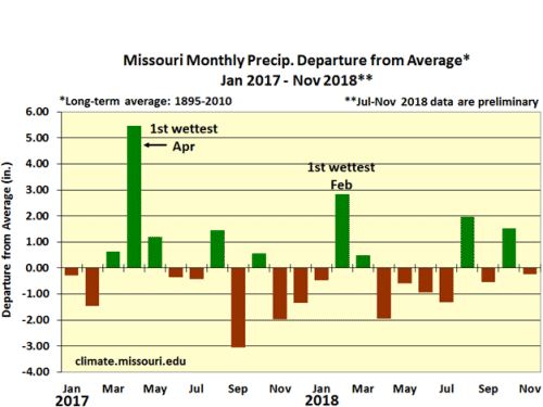
Figure 4.
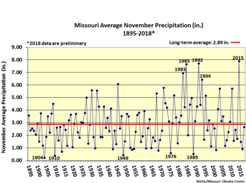
Figure 5.
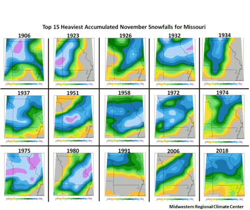
Figure 6.
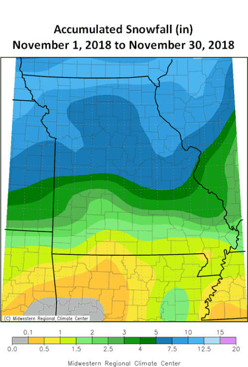
Figure 7.
Figure 8.
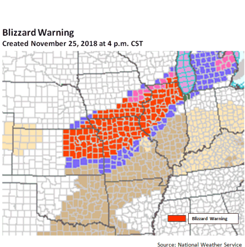
Figure 9.
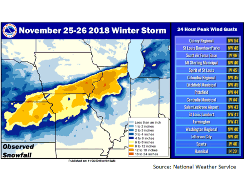
Figure 10.
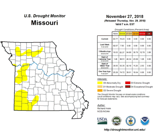
Figure 11.
Source: Pat Guinan, 573-882-5908