
November 2019 Weather and Its Impacts on Missouri
Pat Guinan
State Climatologist
University of Missouri Extension
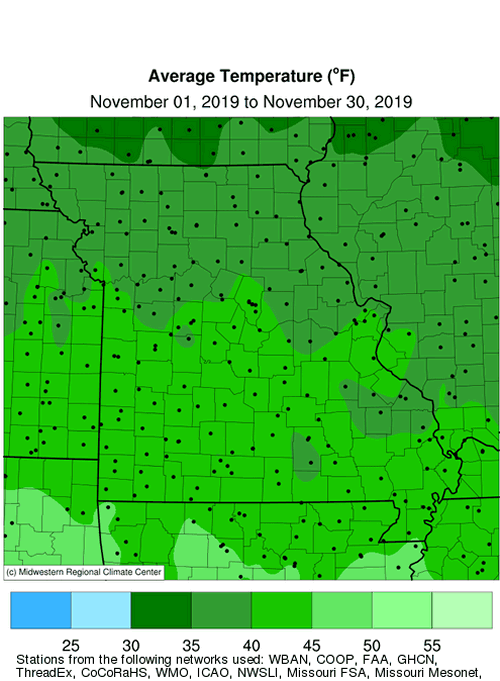
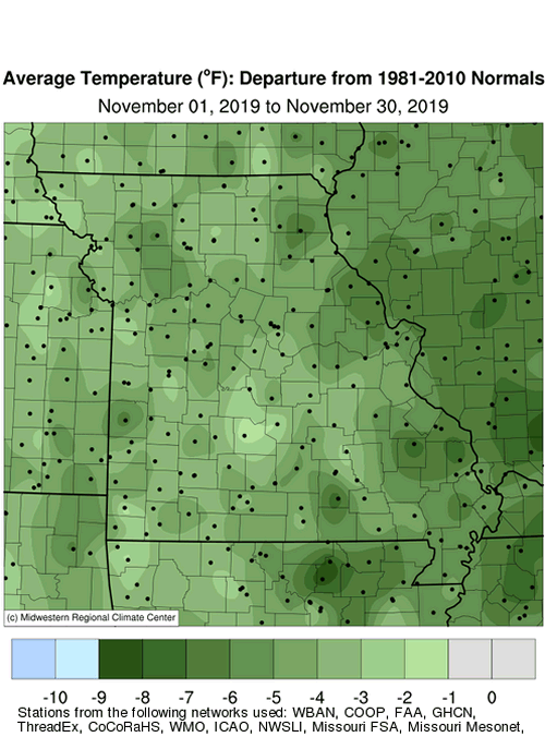
A cold October weather pattern spilled into the first half of November with milder conditions during the latter half of the month, Figure 1. Preliminary data indicate the average statewide November temperature was 40.3�F, 3.5 degrees below the long-term average. It was the second consecutive November with below normal temperatures, Figure 2, and sixth cooler than average month for the year, Figure 3. There were numerous reports of record low temperatures established across the Midwest during the week of November 11-16, Figure 4. Missouri�s coldest temperatures occurred on November 12-13, Table 1.
| Missouri Lowest November 2019 Temperature | |||
| Station Name* | County |
Low Temp (℉) | Date |
| Williamsburg | Callaway | -2 | 12 |
| Smithville Lake | Clay | -1 | 12 |
| Shelbina | Shelby | -1 | 13 |
| Unionville | Putnam | 0 | 12 |
| Conception | Nodaway | 1 | 12 |
| Tarkio #2 | Atchison | 1 | 12 |
| Novelty | Knox | 1 | 12 |
| Albany | Gentry | 2 | 12 |
| Independence | Jackson | 2 | 12 |
| Columbia-Bradford Farm | Boone | 2 | 13 |
| *NWS Cooperative Network or Missouri Mesonet | |||
| Table 1. | |||
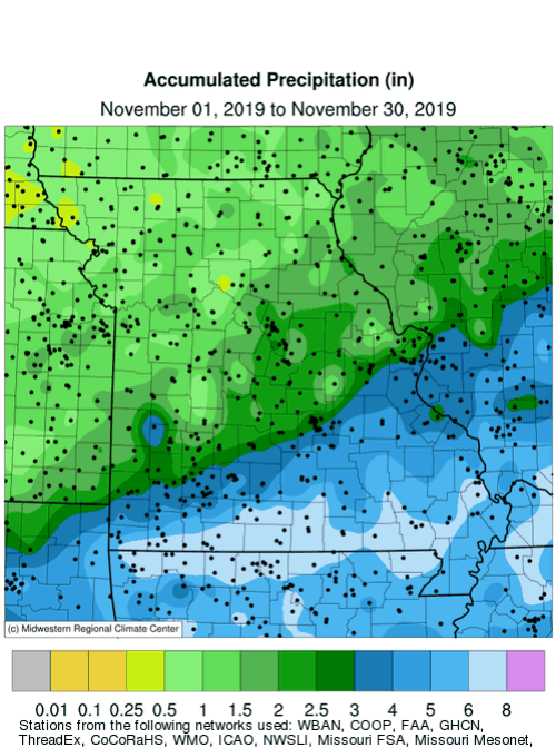
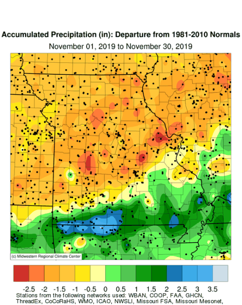
Preliminary precipitation data indicate an average statewide total of 2.83 inches, only 0.06� below the long-term average, Figure 5. It was the third month with below average precipitation for 2019, Figure 6. The Jan-Nov 2019 statewide average precipitation was 52.23 inches, making it the 5th wettest Jan-Nov on record, Figure 7.
According to monthly radar estimates, Figure 8, precipitation amounts increased moving southeastward through the state. Lightest amounts occurred over far northwestern Missouri where less than 1-inch was reported and 1-2 inches were common across the rest of northern Missouri and west central sections. Much of central and east Missouri received 2-3 inches and 3-5 inches were common over southern sections, generally along and southeast of I-44. There were numerous reports of 6-7 inches across far southern Missouri and in the Bootheel. A CoCoRaHS observer near Ava, MO, in Douglas County, reported 8.19 inches for the month.
A significant snow event impacted parts of central and east central Missouri on November 11-12, Table 2.
| Missouri Heaviest Snowfall Reports, November 11-12, 2019 | ||
| Station Name* | County |
Snowfall (in.) |
| Columbia 2.3SE | Boone | 4.8 |
| Middletown 3.5SW | Montgomery | 4.3 |
| Kingdom City 3.2NNW | Callaway | 3.8 |
| Silex 3E | Lincoln | 3.3 |
| Columbia UofM | Boone | 3.0 |
| Louisiana | Pike | 2.7 |
| Ballwin 0.5NNW | St. Louis | 2.5 |
| St. Charles 2.3NE | St. Charles | 2.5 |
| Boonville 0.5ESE | Cooper | 2.4 |
| *NWS Cooperative Network or CoCoRaHS Network | ||
| Table 2. | ||
As of November 24th, the Missouri Agricultural Statistics Service reported 98% of the topsoil moisture supplies were in adequate to surplus condition statewide, and 98% of the subsoil moisture supply as adequate to surplus. Winter wheat was reported to be 77% emerged and 41% in good to excellent condition. The majority of hay supplies and other roughages, 89%, were reported adequate to surplus, and 98% of stock water supplies were adequate to surplus.
Jump to:
- Figure 1
- Figure 2
- Figure 3
- Figure 4
- Figure 5
- Figure 6
- Figure 7
- Figure 8
- Figure 9
- Figure 10
- Figure 11
- Figure 12
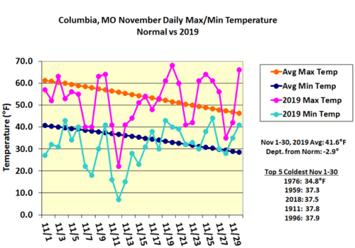
Figure 1.
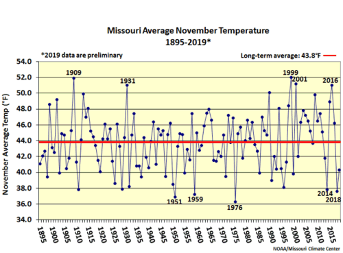
Figure 2.
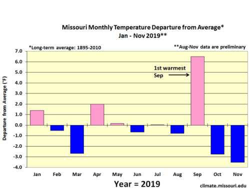
Figure 3.
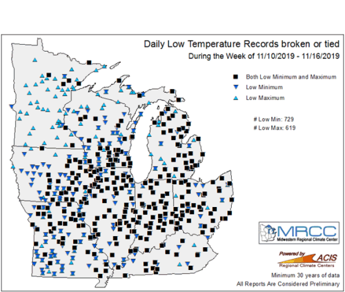
Figure 4.
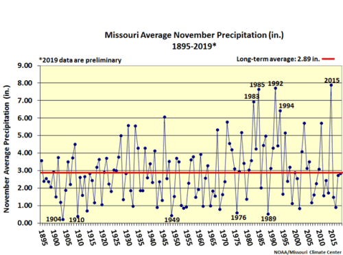
Figure 5.
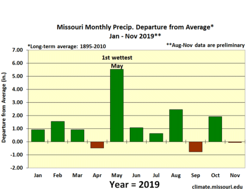
Figure 6.
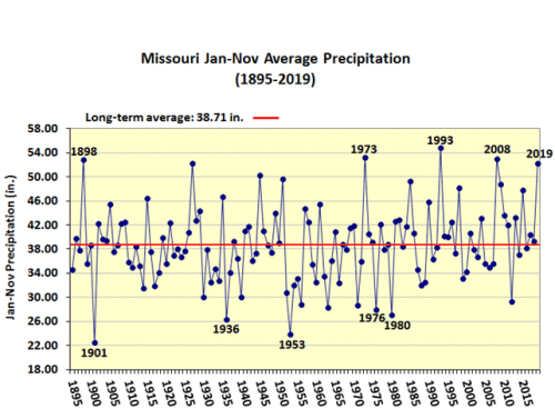
Figure 7.
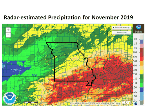
Figure 8.
Source: Pat Guinan, 573-882-5908