
January 2014 Weather and Its Impacts on Missouri
Pat Guinan
State Climatologist
Commercial Agriculture/University of Missouri Extension
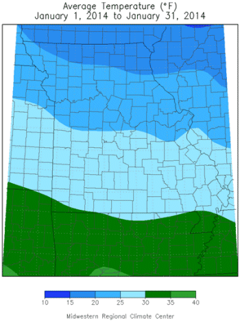
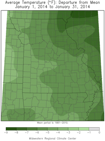
Cold temperatures dominated during January and continued the trend of cool weather since March of last year, Figure 1. Over the past 11 months, only September 2013 averaged warmer than normal. Preliminary data for January indicate the average statewide temperature was 25.0°F, or 4.9° below the long-term normal. It was the coldest January since 2010, which also had an average temperature of 25.0°F. Similarly, 2010 and 2014 are the coldest Januaries experienced since January 1985, Figure 2. Preliminary data for this meteorological winter indicates an average statewide December-January temperature of 27.6°F (4.1° below normal), slightly colder than the December 2009 and January 2010 period, and the coldest since December 2000 and January 2001, Figure 3.
A polar jet stream was oriented from northwest to southeast over Missouri for much of January and allowed several arctic cold fronts to barrel through the region, bringing reinforcing shots of frigid air. The fronts were accompanied with gusty winds and bitterly cold wind chills that dipped to -10 to -30°F. There were brief warm-ups between these cold-air incursions, but cold temperatures dominated for the month, Figure 4.
On January 5, an arctic cold front, accompanied by strong gusty winds, brought bitterly cold wind chills and one of coldest air masses in nearly two decades across Missouri. Minimum temperatures dropped lower than -10°F in many locations during the morning hours of January 6-7, Figures 5 and 6. Additionally, high temperatures on January 6th remained at or below 0°F across parts of northern and central Missouri, an occasion that hasn't occurred since December 1989.
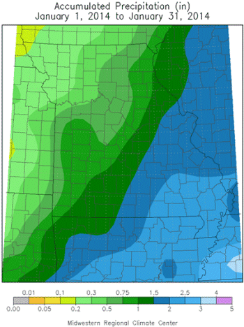
Significant precipitation events were scarce during January with preliminary statewide precipitation averaging 1.17 inches, or nearly one inch below normal. Amounts were lightest across northwest Missouri and increased while traveling southeastward through the state. Generally less than 1-inch fell across the northwestern half of Missouri to more than two inches over southeastern sections. Some of the lightest monthly totals were found in northwestern and west central counties where observers in Worth, Buchanan, Jackson and DeKalb counties reported 0.11", 0.08", 0.06", and 0.04", respectively. Heaviest amounts were reported in far southeastern Missouri where locations in Scott, Shannon, Butler and Bollinger counties reported 2.52", 2.68", 2.68", and 2.69", respectively.
Even though precipitation was below normal for January, it fell mostly in the form of snow or ice. Accordingly, snowfall totals averaged near to above normal in several locations, especially across portions of north central, northeastern, central and southern Missouri where 5-10 inches were common, Figure 7. Some of the heaviest totals were in east central sections, where more than a foot fell. The St. Louis area received 12-16 inches with most of it falling during a snowstorm on January 5, Figure 8. Officially, St. Louis Lambert Airport reported 10.8 inches on January 5th, and a monthly total of 15.8 inches, making it the 6th snowiest January on record.
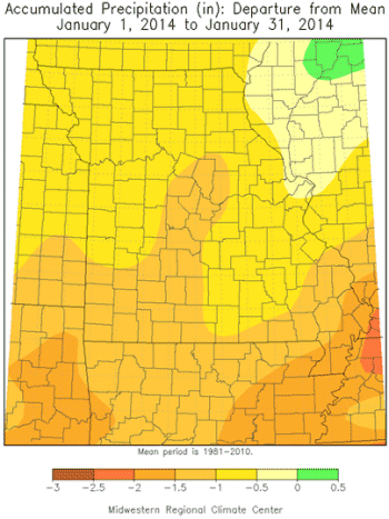
The below normal precipitation in January did little to mitigate the long-term dryness impacting northern and central Missouri. According to the end-of-January Drought Monitor map, abnormally dry to moderate drought conditions persisted across much of northern and central Missouri, Figure 9. East central counties experienced some surface water recharge from heavier precipitation events, but little recovery in soil moisture since soils were frozen for most of the month.
The longevity of frozen soils this winter is notable and unusual, as indicated by observations taken at the Greenley Research Center, near Novelty, MO, in northeastern Missouri, Figure 10. Soils have been frozen at the center since December 5th. Additionally, the frost line has penetrated deeper than usual across Missouri, especially across northern and central sections, where cold temperatures, lack of extended snow cover and dry soils have dominated.
Soil temperature observations at the South Farm Research Center, near Columbia, began in 1967 and are collected at various depths. On January 6, 2014, the minimum soil temperature under sod, at the 8-inch depth, reached 27°F and surpassed the previous records of 28°F set at South Farm in January 1982 and February 1996. The minimum 8-inch soil temperature dropped to 25°F on January 7, 2014 and is the current record. Since observations began at South Farm, the frost line at Columbia has never reached the 20-inch depth, under sod. Prior to this year, the coldest temperature at 20 inches, under sod, was 35°F in February 1996. The record was tied on January 29, 2014, when the 20-inch soil temperature reached 35°F at South Farm. The sub-zero temperatures and deep frost line across Missouri this winter has contributed to more incidences of buried water lines freezing in the region.
Two other notable January weather anomalies in Missouri include unusually windy conditions and minimal atmospheric moisture. A strong pressure gradient resided across Missouri for much of the month and resulted in many blustery days for the state. Using Columbia, MO as a midpoint for the state, Figure 11 indicates January 2014 was the windiest January since 1985, tying that month with an average wind speed of 12.6 mph. Only January 1972 had a higher average wind speed, 12.7 mph. In addition to windy days, the cold air masses from Canada were moisture starved, and relative humidity, or dew points, were consistently low for the month. Dew point temperature is the temperature at which the air becomes saturated at constant barometric pressure. Using Columbia, MO as a midpoint for the state, the average January dew point this year was 12.5°F, nearly 8 degrees below the long-term average, and the lowest average January dew point since 1979, Figure 12. If you experienced an inordinate amount of dry eyes, or awakened with some early morning sore throats, the unusually dry air is likely to blame. January 2014 was a good month for manufacturers of space heaters, humidifiers, moisturizers and throat soothers.
Jump to:
- Figure 1
- Figure 2
- Figure 3
- Figure 4
- Figure 5
- Figure 6
- Figure 7
- Figure 8
- Figure 9
- Figure 10
- Figure 11
- Figure 12
- Figure 13
- Figure 14
- Figure 15
- Figure 16
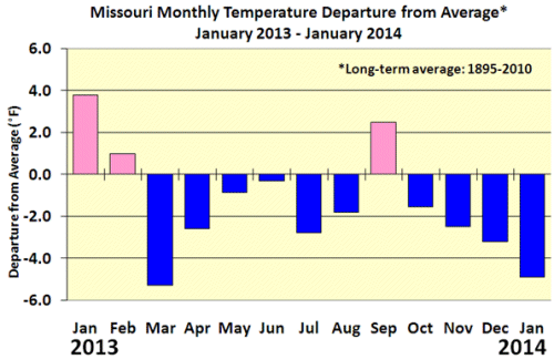
Figure 1
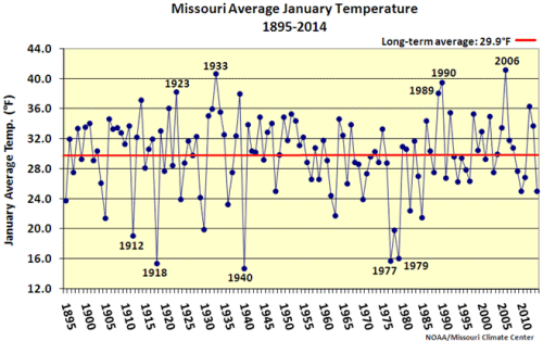
Figure 2
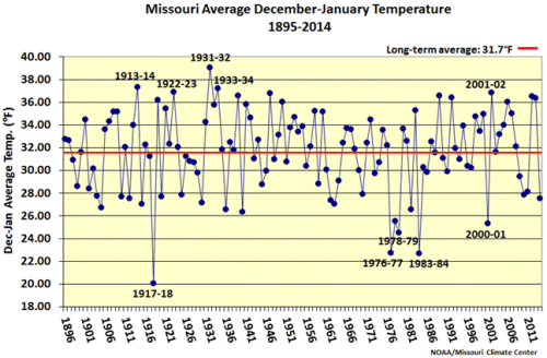
Figure 3
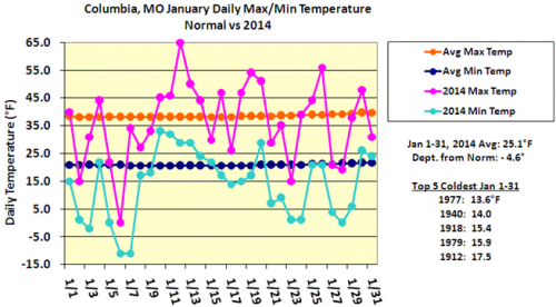
Figure 4
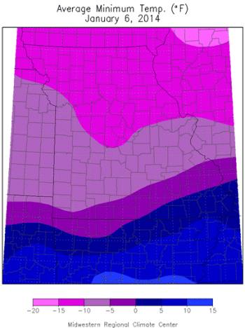
Figure 5

Figure 6
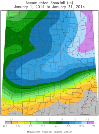
Figure 7
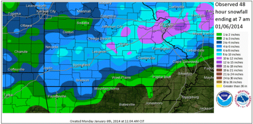
Figure 8 - Source: NOAA/NWS
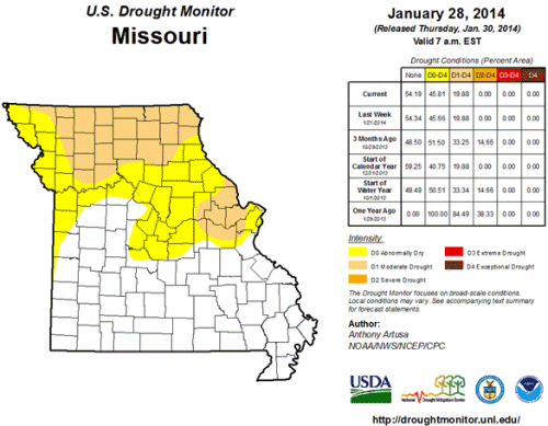
Figure 9
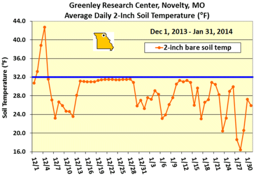
Figure 10
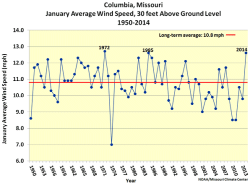
Figure 11
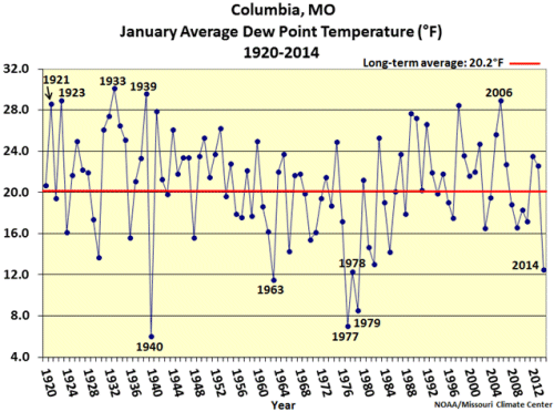
Figure 12
Source: Pat Guinan, 573-882-5908