
January 2020 Weather and Its Impacts on Missouri
Pat Guinan
State Climatologist
University of Missouri Extension
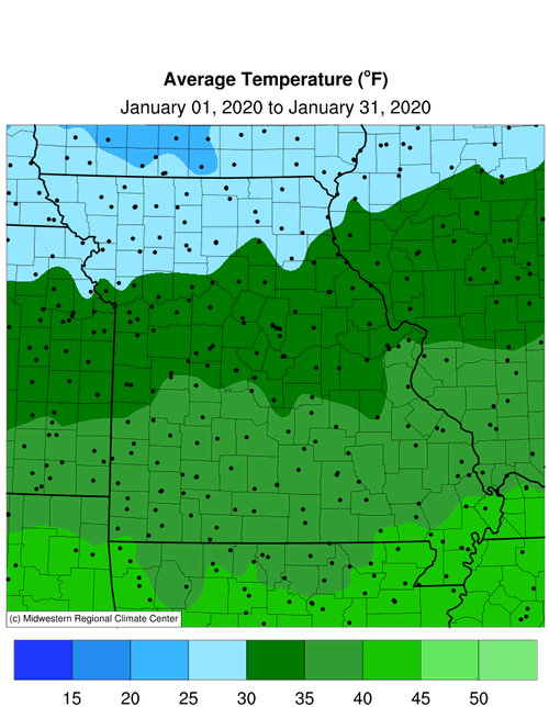
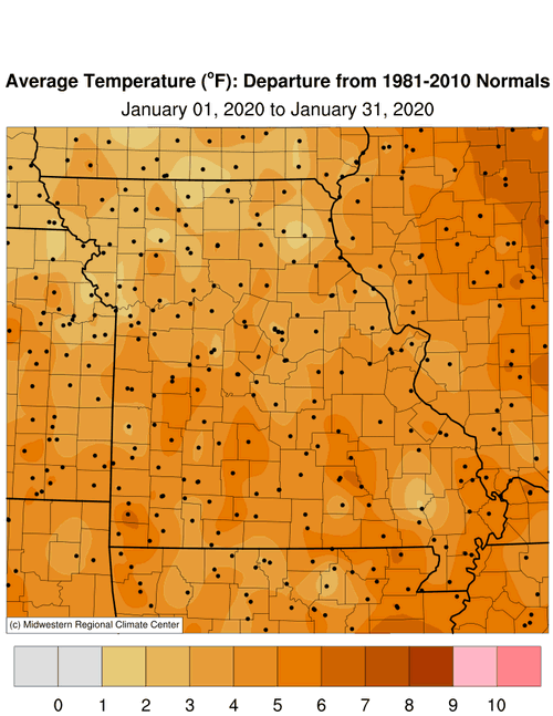
An unsettled weather pattern impacted Missouri in January with significant precipitation events. Daily temperatures were mostly above normal during the first half of the month with cooler conditions during the latter half, Figure 1. Cloudier weather during the final two weeks of January suppressed maximum temperatures while elevating minimum temperatures. Preliminary data indicate the average statewide temperature for January was 33.9�F, or 4.3 degrees above the long-term average, and follows the general trend toward milder Januaries over the past couple decades, Figure 2. It was the second consecutive month with well above average temperatures, Figure 3, and the warmest Dec-Jan period since 2011-12. The Dec 2019-Jan 2020 temperature average was 36.8�F, making it a 5-way tie for 2nd warmest Dec-Jan on record for Missouri, Figure 4.
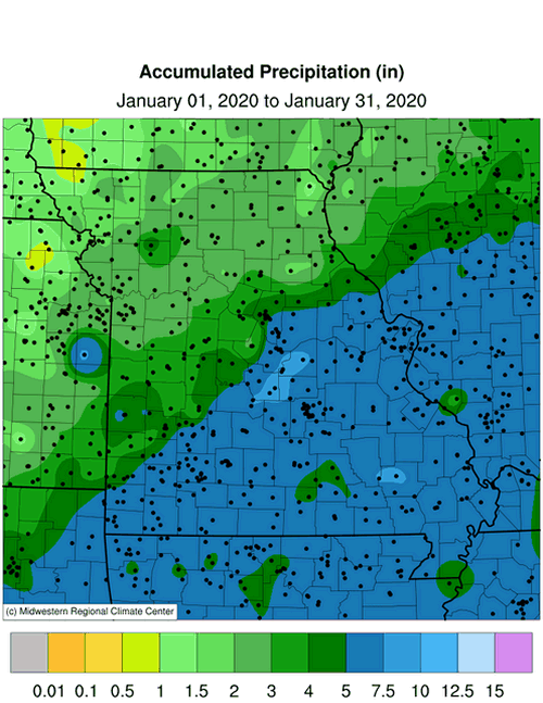
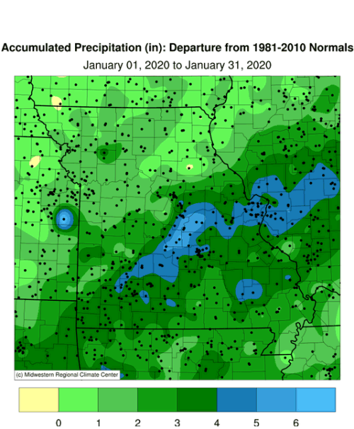
Preliminary precipitation data indicated a statewide average of 4.63 inches, or 2.51 inches above the long-term average. It was the wettest January in 15 years, Figure 5, and 8th wettest January on record. It was the ninth wetter than average month in the past 13 months, Figure 6.
Precipitation totals were above average statewide but varied, generally increasing from northwest to southeast. Totals ranged from around 1.5 inches in the northwestern tip to more than 7-inches in several east central, south central and southeastern counties. Some of the heaviest monthly totals are listed in Table 2.
| January 2020 Heaviest Precipitation Totals | ||
| Station Name* | County |
Precipitation (in.) |
| Linn 0.8SE | Osage | 8.55 |
| Brumley 5.6SW | Camden | 8.46 |
| Buffalo 2N | Dallas | 8.35 |
| Patterson 3.6N | Wayne | 8.32 |
| St. Louis 5.7SW | St. Louis City | 8.07 |
| Jackson | Cape Girardeau | 7.98 |
| Iberia | Miller | 7.94 |
| Morrisville 2SW | Polk | 7.61 |
| Jefferson City 3.0ESE | Cole | 7.61 |
| Fenton 4.1S | Jefferson | 7.55 |
| Josephville 1.1S | St. Charles | 7.51 |
| Rolla 3.7WNW | Phelps | 7.48 |
| Vienna 4.3NNW | Maries | 7.44 |
| *Rain gauges are from the NWS Cooperative Network or CoCoRaHS Network | ||
| Table 2. | ||
The biggest precipitation event to impact Missouri occurred on January 10-11. A slow-moving but strong frontal boundary moved across the state and dropped 1-4 inches of rain over the next 24-hours, Figure 7. The storm system also spawned severe weather with high winds, hail and five tornadoes reported in southern Missouri, Figure 8.
There were a couple notable snow events during the month. The first event occurred on January 12 when 1-3 inches fell across the northwestern 2/3 of Missouri. Another event dropped 2-9 inches over the northern 2/3 of Missouri on Jan 23-24. Heaviest monthly totals occurred over portions of north central and central Missouri where 7.5 to 10 inches were common, and localized totals were over a foot, Figure 9. Unionville reported the heaviest January snowfall with 15.3 inches. The University of Missouri closed its Columbia campus on January 17 due to icy conditions and on January 24 due to heavy snow and hazardous roads.
Soil moisture levels remained unusually high across a large portion of the Missouri and Mississippi River Basins at the end of January, Figure 10, and set the stage for a significant spring flood season.
Jump to:
- Figure 1
- Figure 2
- Figure 3
- Figure 4
- Figure 5
- Figure 6
- Figure 7
- Figure 8
- Figure 9
- Figure 10
- Figure 11
- Figure 12
- Figure 13
- Figure 14
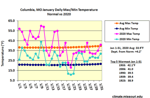
Figure 1.
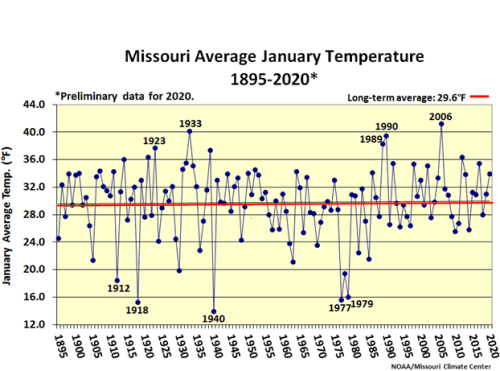
Figure 2.
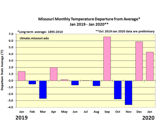
Figure 3.
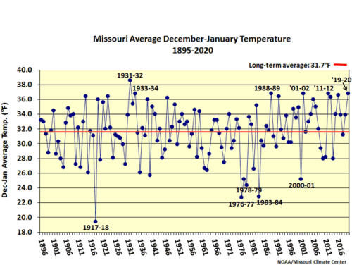
Figure 4.

Figure 5.
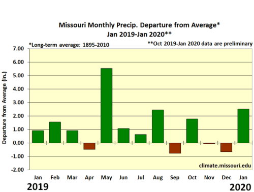
Figure 6.
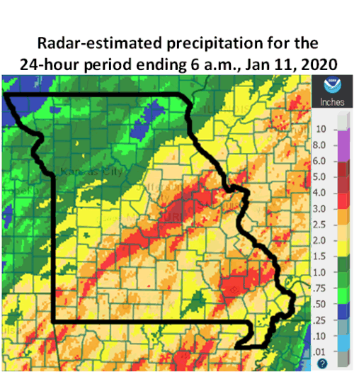
Figure 7.
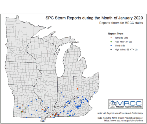
Figure 8.
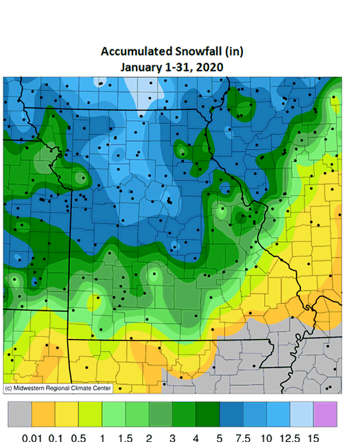
Figure 9.
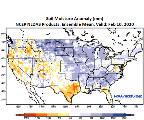
Figure 10.
Source: Pat Guinan, 573-882-5908