
January 2021 Weather and Its Impacts on Missouri
Pat Guinan
State Climatologist
University of Missouri Extension
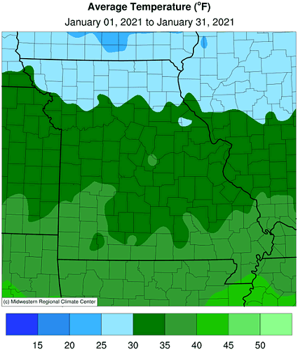
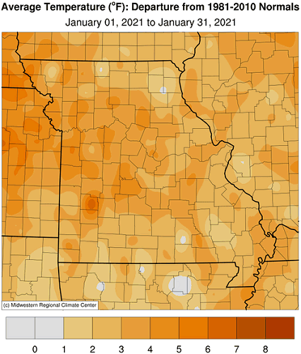
Alternating periods of seasonably mild weather and a slightly cooler than average conditions were the rule across Missouri during January. More than half the January days were overcast which kept the majority of overnight minimum temperatures elevated and above normal throughout the month, Figure 1. Preliminary data indicate the average statewide temperature for January was 33.6°F, or 4.0 degrees above the long-term average, and follows the general trend of mild Januaries over the past couple decades, Figure 2. It was the third consecutive month with above average temperatures, Figure 3, and the 7th warmest Nov-Jan period on record, tying with 2005-2006, Figure 4. The coldest weather occurred toward the end of the month when the northern half of the state dropped to single digits and lower. Memphis, MO, in Scotland Co., reported -6°F on January 28th.
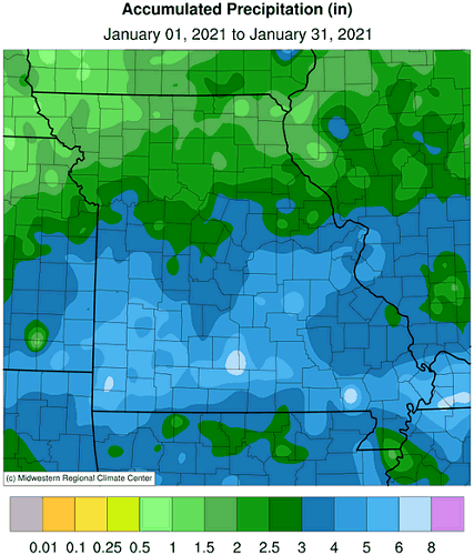
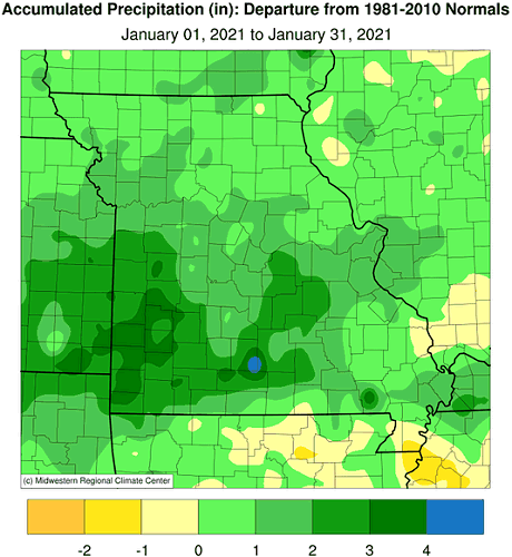
An unsettled January weather pattern impacted Missouri with significant precipitation events bookending the month. Preliminary precipitation data indicated a statewide average of 3.32 inches, or 1.20 inches above the long-term average. It was the third consecutive wet January for the state, Figure 5, and eighth wetter than average month in the past 13 months, Figure 6.
Precipitation totals were above average statewide but varied, generally increasing from north to south. Totals ranged from just over 1-inch in the northwestern corner to more than 5-inches in some far southern counties. Heaviest monthly totals are listed in Table 1.
| January 2021 Heaviest Precipitation Totals | ||
| Station Name* | County |
Precipitation (in.) |
| Neosho | Newton | 6.63 |
| Pineville 7.5ESE | McDonald | 6.55 |
| Ava 6NW | Douglas | 6.53 |
| Halltown 5NW | Lawrence | 6.00 |
| Lamar 0.3ESE | Barton | 5.95 |
| Mountain View 7.9W | Howell | 5.91 |
| Stockton 2.5NNW | Cedar | 5.84 |
| Dunnegan 2.4NNW | Polk | 5.84 |
| Summersville 3.6S | Texas | 5.84 |
| Steeleville 10.2SSE | Crawford | 5.75 |
| Sikeston 1.7ENE | Scott | 5.75 |
| Carthage 1.5S | Japser | 5.73 |
| Crane 0.7SSW | Stone | 5.72 |
| Willard 5.8NNE | Greene | 5.67 |
| *Precipitation gauges are from the NWS Cooperative Network or CoCoRaHS Network | ||
| Table 1. | ||
There were a few significant precipitation events impacting the state during January with the largest ones occurring during the beginning and end of the month. A few snow and ice events also occurred with heaviest monthly snow totals impacting portions of far northern Missouri where 7.5 to 12 inches were common, Figure 7. The heaviest monthly snowfall total came from the northwestern tip of Missouri where a CoCoRaHS observer from Nodaway County, 3.9 miles west-southwest of Hopkins, reported 13.5 inches.
The wetter January weather mitigated dryness concerns over some parts of the state. As of February 2, 2020, the U.S. Drought Monitor map indicated small pockets of abnormally dry conditions impacting Missouri, Figure 8.
Jump to:
- Figure 1
- Figure 2
- Figure 3
- Figure 4
- Figure 5
- Figure 6
- Figure 7
- Figure 8
- Figure 9
- Figure 10
- Figure 11
- Figure 12
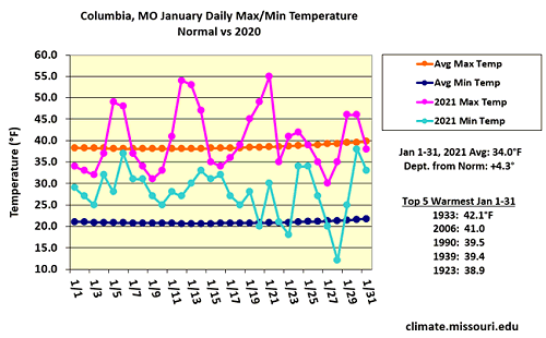
Figure 1.
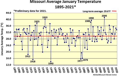
Figure 2.
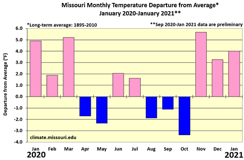
Figure 3.
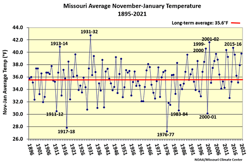
Figure 4.
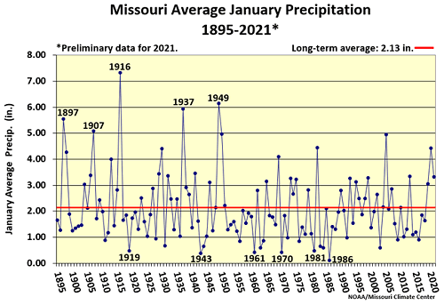
Figure 5.
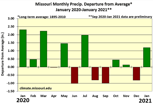
Figure 6.
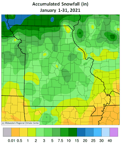
Figure 7.
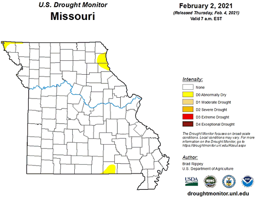
Figure 8.
Source: Pat Guinan, 573-882-5908