
Missouri's snowy winter: How La Niña and cold temperatures teamed up to bring more snow
With snowfall totals above average across the state, experts explain the weather patterns behind the wintry season-and what it could mean as spring approaches.
February 26, 2025
Written by Shannon Beck
As sunshine and spring-like temperatures help dig Missourians across the middle and southern portions of the state out of yet another round of snow, some are asking, 'Where did it all come from?' According to Zack Leasor, Missouri State Climatologist and associate professor in the University of Missouri's School of Natural Resources, a weather phenomenon known as La Niña - cooler than average water surface temperatures in the Pacific Ocean - is partly to blame.
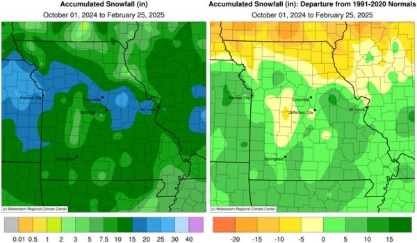
"Pacific Ocean sea surface temperatures are just a bit below average creating a weak La Niña event. La Niña events can increase wintertime precipitation, especially across the eastern half of the state," Leasor said. "The influence of La Nina could be seen with many notable winter storms impacting the eastern and southeastern U.S. and while not all of Missouri received above normal wintertime precipitation, many locations have received more snowfall on average for this season."
On its own, La Niña doesn't necessarily guarantee a snowier winter. However, this year's below-average temperatures combined with increased moisture to the east led to much higher-than-average snowfall totals-at least 20 inches in many parts of the state so far.
| Highest Season-to-Date Snowfall Totals in Missouri 2024-25 | ||
| Station Name | County | Snowfall Total (in.) |
| MONTGOMERY CITY 2 | Montgomery | 24.0 |
| PARKVILLE 6.2 WNW | Platte | 23.0 |
| COSBY 1.2 E | Andrew | 23.0 |
| BLUE SPRINGS 2.3 WNW | Jackson | 22.9 |
| KANSAS CITY 8.0 SSW | Jackson | 22.7 |
| WELDON SPRING NWS | Saint Charles | 22.5 |
| ST. JOSEPH 4.4 E | Buchanan | 22.5 |
| BALLWIN 0.5 NNW | Saint Louis | 21.5 |
| COLOMA | Carroll | 21.2 |
| PLEASANT VALLEY 0.5 NW | Clay | 21.2 |
| ST. CHARLES 2.3 NE | Saint Charles | 21.1 |
| GLADSTONE 2.6 N | Clay | 21.0 |
| KANSAS CITY INTL AP | Platte | 20.5 |
A Colder-Than-Normal Winter
Missouri as a whole saw temperatures 2.5 degrees below average in January, and as of Feb. 24, even with warmer days in the forecast, February is on track to be up to 4 degrees below average, according to Leasor.
"This winter would have looked even more impressive if we didn't have December," Leasor added, noting that December's temperatures were nearly 5 degrees above normal.
Despite the perception that this has been an unusually harsh winter, Leasor pointed out that the last time Missourians experienced a season this cold was the 2020-2021 winter.
"I've had people asking me if this was a record-breaking winter for snowfall, and it's definitely not going to break any records, but we are above average for snowfall through most of the state," Leasor said.
Could More Snow Be Ahead?
Even with this week's warm spell, Leasor did not rule out the potential for more winter precipitation, noting that even southern Missouri has experienced snowfall as late as early April.
Specializing in drought research, Leasor also emphasized the importance of continued precipitation-whether frozen or liquid-as Missouri heads into spring. He noted that the state experienced a drought this past fall, and even with the above-average snowfall, there hasn't been enough total precipitation for a full recovery, except in the bootheel region.
A Silver Lining for Farmers
One potential benefit of this year's colder temperatures? A reduction in soilborne pests.
"Colder soil temperatures - sometimes that can be good, especially when coming off several years of warmer winters like we just had, as it can mitigate things like in-ground pests," he said.
Source: Zack Leasor, 573-882-5908