
December 2017 Weather and Its Impacts on Missouri
Pat Guinan
State Climatologist
Commercial Agriculture/University of Missouri Extension
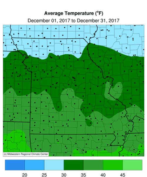
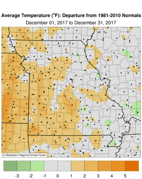
A weather pattern change during the last 10 days of December ended an unseasonably mild period that dominated during the first three weeks of the month, Figure 1. The jet stream buckled, allowing arctic air masses to spill southeastward into the Show Me State, bringing some of the coldest temperatures of the year across northern Missouri, Table 1. Temperatures in Missouri were averaging 4-7 degrees above normal during the first 3 weeks of December, Figure 2, but flipped 8 to 14 degrees below normal for the last 10 days of the month, Figure 3.
| December 2017 Minimum Daily Temperature | |||
| Location* | County | Min Temp (�F) | Date |
| Albany | Gentry | -17 | 27 |
| Corning | Atchison | -15 | 27 |
| Unionville | Putnam | -15 | 31 |
| Memphis | Scotland | -15 | 28 |
| Green City 5N | Sullivan | -13 | 28 |
| Maryville 2E | Nodaway | -13 | 28 |
| Downing | Schuyler | -13 | 28 |
| *NWS Cooperative network and Missouri Mesonet | |||
| Table 1. | |||
Preliminary data indicate the average statewide temperature for December was 34.1�F, or 1 degree above normal. This follows a trend of mild Decembers over the past few decades, Figure 4. Despite the end-of-the-year cold spell, 2017 will likely rank as Missouri�s 6th or 7th warmest year on record, Figure 5. The warmth of 2017 outweighed the cold by far. The first four months of 2017 were unusually mild, and autumn was warmer than average, Figure 6.
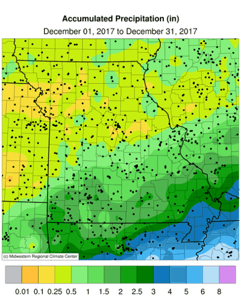
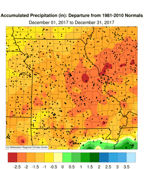
For the second year in a row, below normal precipitation impacted Missouri during December, Figure 7. The statewide average total for the month was 1.07 inches, or 1.27 inches below average. It was also the second consecutive month with below average precipitation, Figure 8, and it will likely be the driest Nov-Dec period in nearly 3 decades, or since 1989, Figure 9. Preliminary precipitation data indicate the statewide average for Nov-Dec 2017 was just under 2-inches, or 30% of normal.
For some locations, especially eastern and southern sections, the precipitation deficits began accumulating last summer, Figure 10. By the end of 2017, abnormal dryness to extreme drought was impacting much of the state, according to the U.S. Drought Monitor, Figure 11.
The cold weather near the end of December translated to higher than usual energy consumption and stressful conditions for outdoor workers, exposed livestock and pets. Some ranchers dealt with chopping ice for livestock due to frozen ponds. Additionally, the extended period of sub-freezing temperatures, in combination with little to no snowpack, and dry soils, contributed toward an unusually deep frost line in the soil, approaching a depth of 8 inches or deeper in some locations. The dry ground conditions also contributed to shifting soil, and there were numerous reports of frozen pipes and broken water mains toward the end of the month.
No major winter storms impacted Missouri during the month, but a severe weather event occurred during the afternoon of December 4th. The following is a tornado survey report submitted by the National Weather Service Forecast Office in Pleasant Hill, MO:
During the afternoon of December 4, 2017 a line of thunderstorms formed in western Missouri and through the rest of the afternoon moved eastward into central Missouri. Several low-topped supercells formed along this line of storms; one of which produced a tornado that did damage to residences between Higbee and Renick, Missouri. The worst of the damage occurred just east of Higbee, where a couple residences were completely destroyed, one of which was a mobile home. One person was critically injured, and another person suffered minor injuries. The tornado lasted about 15 minutes, and eventually dissipated just east of Renick, near the Randolph/Monroe County line.
| Tornado - Renick, MO, Randolph County, Missouri | |
| Date | December 4, 2017 |
| Time (CST) | 4:54 PM - 5:09 PM |
| EF Rating | EF-1 |
| Est. Peak Winds | 100 mph |
| Path Length | 11.2 miles |
| Max Width | 30 yards |
| Inujuries/Deaths | 2 Injuries |
| Summary: This tornado formed just east of Higbee and just west of Road 2550. The tornado lasted approximately 15 minutes, and traveled a little over 11 miles. The worst of the damage occurred just south of Moberly, near the town of Renick, where a mobile home and a house built into an earthen berm were completely destroyed. Vehicles in the area were also tossed long distances, and several outbuildings were destroyed. The tornado eventually dissipated just west of the Randolph/Monroe County line, just south of Highway M. | |
Jump to:
- Figure 1
- Figure 2
- Figure 3
- Figure 4
- Figure 5
- Figure 6
- Figure 7
- Figure 8
- Figure 9
- Figure 10
- Figure 11
- Figure 12
- Figure 13
- Figure 14
- Figure 15
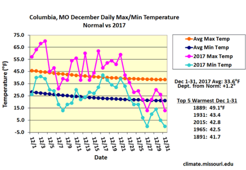
Figure 1.
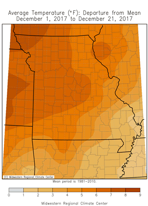
Figure 2.
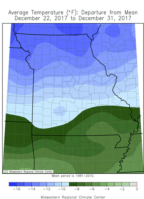
Figure 3.
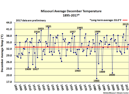
Figure 4.
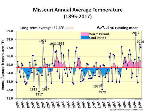
Figure 5.
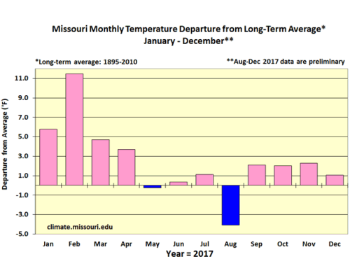
Figure 6.
Figure 7.
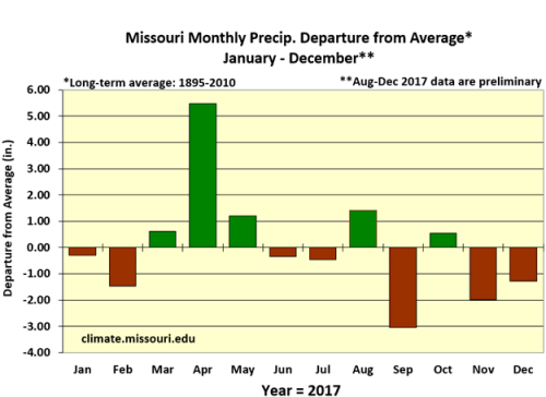
Figure 8.
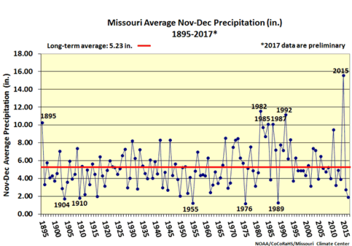
Figure 9.
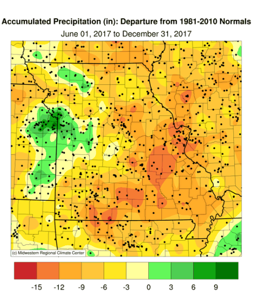
Figure 10.
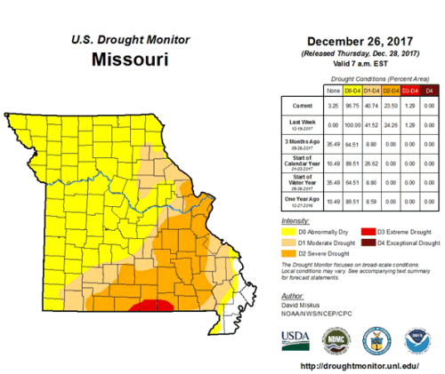
Figure 11.
Source: Pat Guinan, 573-882-5908