
December 2019 Weather and Its Impacts on Missouri
Pat Guinan
State Climatologist
University of Missouri Extension
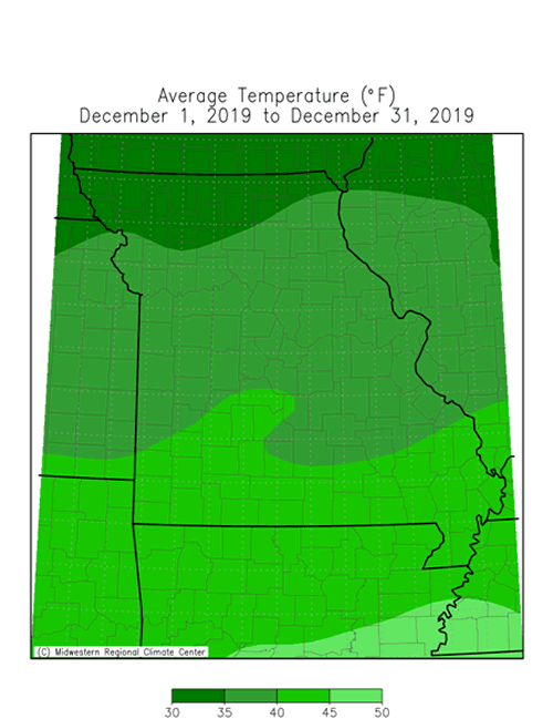
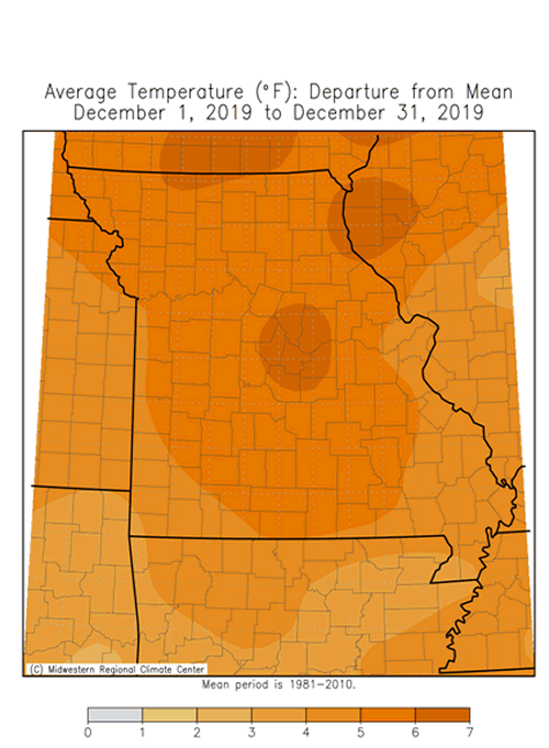
A mild weather pattern established itself across Missouri during December with above normal temperatures dominating throughout the month, Figure 1. Preliminary data indicate the average statewide December temperature for Missouri was 38.9�F, or 5.6� above the long-term average. It was the 10th warmest December on record and warmest December since 2015, Figure 2. Warmest temperatures for the month occurred around Christmas time, Table 1.
| Missouri Highest December 2019 Daily Temperature (℉) | |||
| Station Name* | County |
High Temp (℉) | Date |
| Ozark Beach | Taney | 73 | 26 |
| Washington | Franklin | 72 | 26 |
| Shelbina | Shelby | 71 | 26 |
| Freedom | Osage | 71 | 26 |
| St. Charles 7SSW | St. Charles | 71 | 26 |
| Jefferson City | Cole | 71 | 26 |
| Lakeside | Miller | 71 | 25 |
| Ash Grove 4S | Greene | 71 | 26 |
| Galena | Stone | 71 | 26 |
| Columbia U of M | Boone | 70 | 25 |
| *NWS Cooperative Network or Missouri Mesonet | |||
| Table 1. | |||
It was an up and down year in regard to monthly temperature anomalies with 6 months above normal and 6 months below normal, Figure 3. Preliminary data indicate the annual statewide temperature average was 55.0�F, or 0.4� above the long-term average. Seventeen out of the past twenty-one years have been warmer than average, Figure 4.
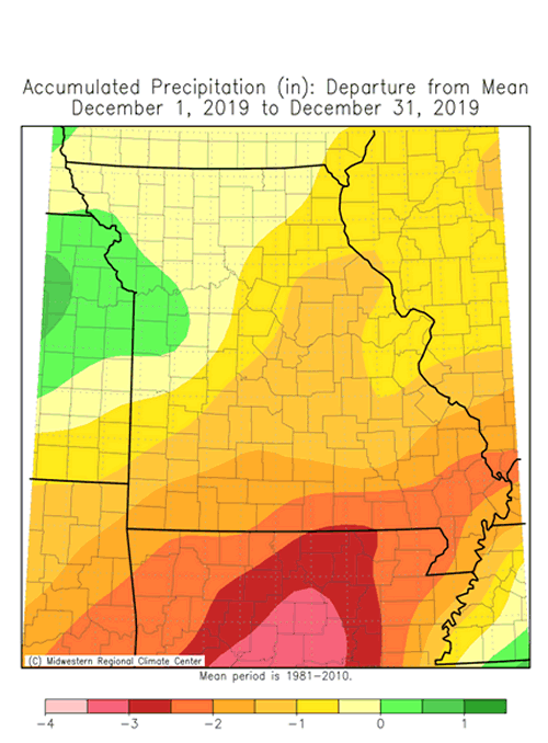
December was a drier than average month with preliminary precipitation data indicating a statewide average total of 1.69 inches, or 0.65 inches below the long-term average. It was the driest December since 2017, Figure 5, and the eighth wetter than average month for the year, Figure 6.
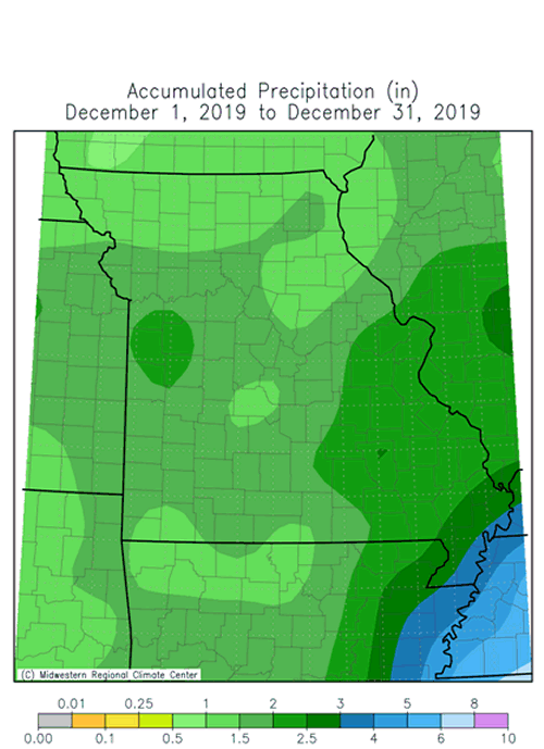
According to December radar estimates, heaviest precipitation totals occurred over portions of central and southeastern Missouri where 1.5-2.5 inches were common, Figure 7. A few locations reported more than 3-inches of precipitation. Locations reporting lightest and heaviest monthly totals are listed in Table 2.
The only notable snow event occurred from Dec 15-17, when most of northern and central Missouri reported 3-6 inches, Figure 8.
| December 2019 Total Precipitation | |||
| Station Name* | County |
Precipitation (in.) | |
| Lightest | Tarkio #2 | Atchison | 0.91 |
| Trenton | Grundy | 0.99 | |
| Gallatin 1W | Daviess | 1.16 | |
| Hopkins 3.9WSW | Nodaway | 1.18 | |
| Monett 4SW | Barry | 1.28 | |
| Heaviest | Edmundsen | St. Louis | 4.35 |
| Ava 0.8NNW | Douglas | 3.94 | |
| Poplar Bluff | Butler | 3.10 | |
| Hornersville | Dunklin | 2.90 | |
| Sikeston 1.7ENE | Scott | 2.81 | |
| *Rain gauges are from the NWS Cooperative Network or CoCoRaHS Network | |||
| Table 2. | |||
The preliminary annual statewide precipitation average for Missouri was 53.78 inches, making 2019 the 7th wettest year on record and wettest year since 2015, Figure 9. According to annual radar estimates for 2019, heaviest amounts, in excess of 70 inches, were reported in some southwestern and southeastern counties, Figure 10. Some of the heaviest annual precipitation reports are listed in Table 3. The heaviest official annual total on record for Missouri occurred in 1957 when Portageville reported 92.77 inches.
| Annual Precipitation for 2019 | |||
| Station Name* | County |
Precipitation (in.) | |
| Anderson 6.8W | McDonald | 82.82 | |
| Seneca | Newton | 82.07 | |
| Anderson 3W | McDonald | 77.70 | |
| Neosho 3.9WNW | Newton | 77.23 | |
| Scott City 0.9E | Scott | 74.11 | |
| Portageville | Pemiscot | 74.06 | |
| Noel 3.8NNE | McDonald | 73.56 | |
| Washburn 5W | Barry | 72.80 | |
| Poplar Bluff | Butler | 72.75 | |
| *Rain gauges are from NWS, CoCoRaHS & Missouri Mesonet | |||
| Table 3. | |||
The mild December weather translated to lower than usual energy consumption and less stressful conditions for outdoor workers, exposed livestock and pets. Despite below average precipitation the past couple months, soil moisture levels remain high and these damp conditions will stick around for the rest of winter considering cold season temperatures, short day length, dormant vegetation and minimal evaporation rates. Additionally, the wet conditions are widespread across much of the north central U.S. and portions of the central Plains and an elevated risk for flooding will likely persist across a large portion of the Missouri and Mississippi River Basins into spring.
Jump to:
- Figure 1
- Figure 2
- Figure 3
- Figure 4
- Figure 5
- Figure 6
- Figure 7
- Figure 8
- Figure 9
- Figure 10
- Figure 11
- Figure 12
- Figure 13
- Figure 14
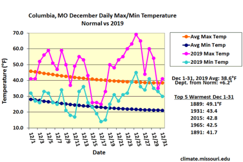
Figure 1.
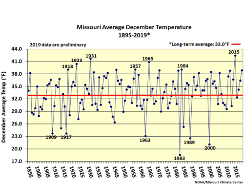
Figure 2.
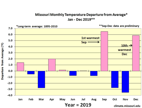
Figure 3.
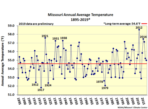
Figure 4.
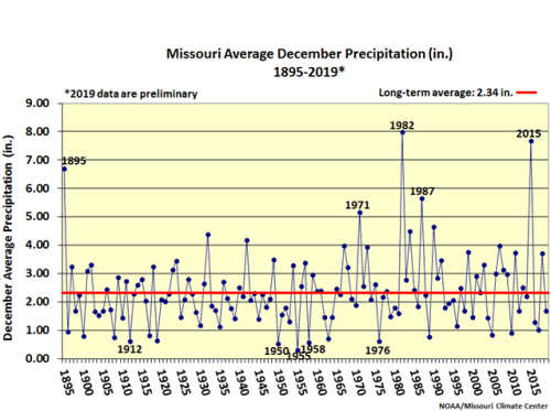
Figure 5.
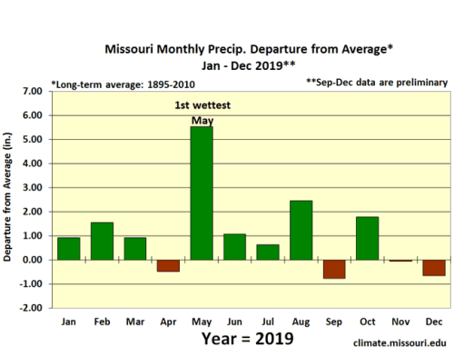
Figure 6.
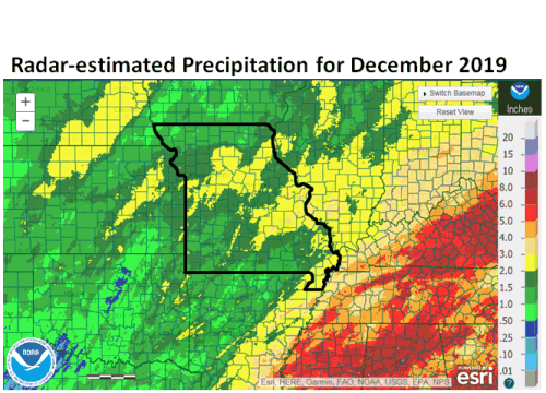
Figure 7.
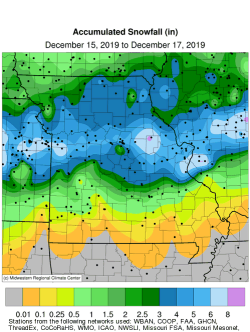
Figure 8.
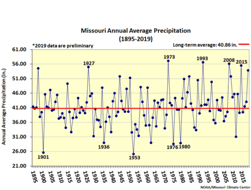
Figure 9.
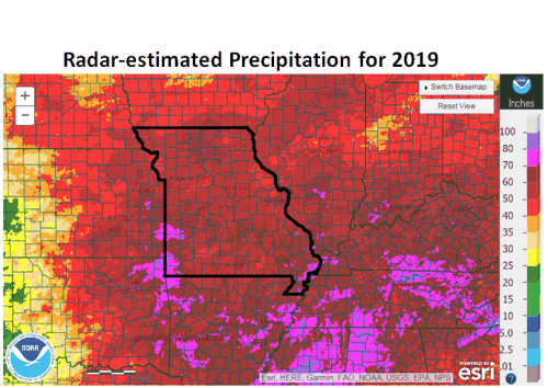
Figure 10.
Source: Pat Guinan, 573-882-5908