June 2011 Weather and Its Impacts on Missouri
Pat Guinan
State Climatologist
Commercial Agriculture/University of Missouri Extension
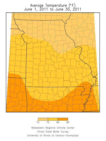
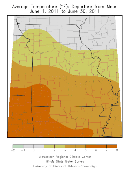
An unusually warm air mass established itself over Missouri during the first ten days of June with oppressive heat impacting the state and several high temperature records being broken. Temperatures averaged 8-10 degrees above normal during the period and it was the hottest June 1-10 period since 1934. Most locations experienced 90 degree plus temperatures on a daily basis and some locations in the Bootheel witnessed several days with triple digit heat.
A pattern change led to a more seasonable and below normal temperature regime for the remainder of June and was a welcome change for many. Overall, monthly temperatures averaged 1-3 degrees above normal across the northern half of Missouri whereas southern sections averaged 3-6 degrees above normal. Springfield, Joplin and West Plains had their 6th, 4th and 4th hottest June on record, respectively.
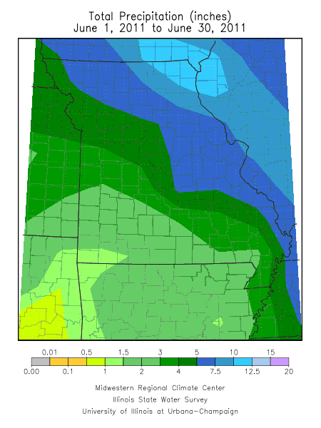
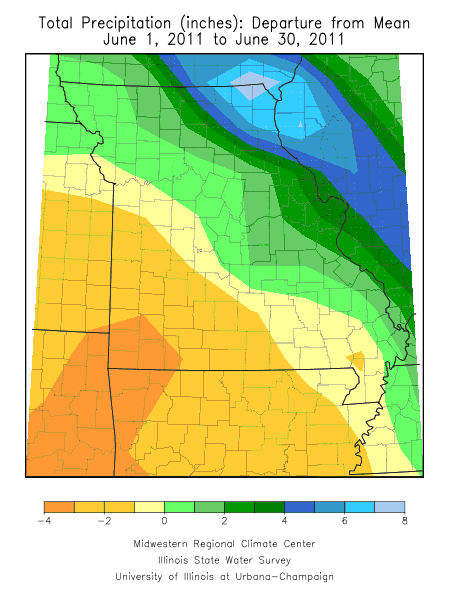
Precipitation was highly variable during the month with a sharp gradient extending from northeastern through southwestern Missouri. Generally, above normal rain fell across the northeastern half of the state with below normal precipitation across the southwestern half. Amounts increased northeast of a St. Joseph to Cape Girardeau line, from 4.5 inches to more than 12 inches. Totals decreased southwest of this line, from 4.5 inches to less than 1-inch.
Some of the highest June rainfall totals occurred in Scotland, Lewis and Clark counties where the communities of Memphis, Monticello and Kahoka reported 13.29, 15.47 and 17.88 inches, respectively. Major flash flooding occurred on June 14-15 in far northeastern Missouri when 5-8 inches fell. Dozens of roads were flooded and cropland was inundated across the area. The Fox River, near Wayland, MO, reached a record level of 23.07 feet and passed the previous high water mark of 21.73 feet set in April 1973.
Abnormally dry conditions were confined to far southwestern sections where several counties reported less than 1-inch for the month. Some of the driest communities were in Christian and Greene counties. A couple observers living near Nixa and Springfield reported 0.53 inches and 0.61 inches, respectively.
Notable severe weather events occurred on June 9-10, 13-14, 17-19, and 26-27 of the month. The most widespread events were bow echoes that impacted central and southern sections on June 17-19 and another bow echo affecting northern Missouri on June 26-27.
Southern portions of the Kansas City metropolitan area and other parts of Jackson, Cass and Johnson counties were buffeted with winds gusting to 60-80 mph during the evening of the 17th. Strong winds associated with this bow echo translated eastward overnight to the Missouri-Illinois border. Another bow echo developed late on the 18th and swept across southern Missouri through the early morning hours of the 19th. Widespread tree damage and power outages were reported with both events.
Another bow echo impacted northern Missouri on June 26-27 and resulted in nearly 100 wind damage reports according to the Storm Prediction Center. It was an unusually strong bow echo that raced eastward across northern Missouri at 60-70 mph and produced extensive damage over portions of northeastern Missouri where National Weather Service wind surveys indicated 70-100 mph winds occurred in some areas. At least 55,000 customers lost power with the most extensive damage noted in Lewis and extreme northeast Marion counties. Significant tree damage, including uprooted trees, property damage to roofs, sheds, grain bins and outbuildings were observed. Two EF-1 tornadoes associated with the system struck the community of Shelbina, MO with tree and property damage reported. The most notable damage was to the city's water plant where much of the roof was removed and tossed 40-50 yards away.
Flooding along the Missouri River was ongoing for much of the month due to record water release occurring from upstream reservoirs in Montana, North Dakota and South Dakota. Water releases from South Dakota's Gavin's Point Dam increased from 84.9 cubic feet/second on June 3rd to 160 cubic feet/second by June 23rd. These record releases translated to major flooding downstream to St. Joseph, MO and moderate flooding along the Missouri River from Kansas City to Jefferson City, MO. Generally, minor flooding was reported east of Jefferson City to St. Charles, MO. Thousands of acres of cropland were flooded in northwestern Missouri where overtopped levees and levy breeches worsened the situation. Atchison and Holt counties, in the northwest corner of the state, were experiencing numerous impacts with flooded residences, closed roads and inundated cropland.