June 2013 Weather and Its Impacts on Missouri
Pat Guinan
State Climatologist
Commercial Agriculture/University of Missouri Extension
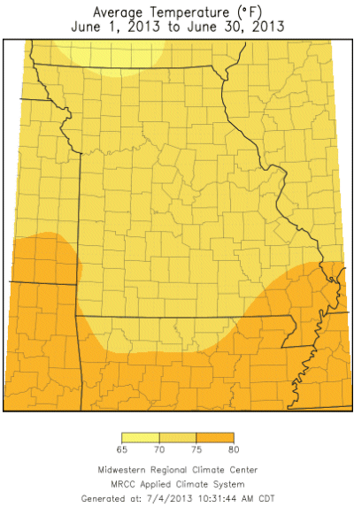
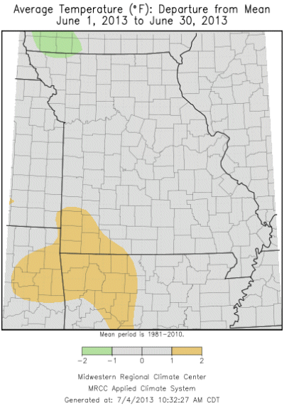
The cool spring weather began transitioning toward a more seasonable summer-like pattern during June, with below normal temperatures at the beginning of the month climbing to near to above normal conditions for much of the rest of the month, Figure 1. Preliminary temperature data for the state indicate a statewide average June temperature of 73.1°F, or 0.1° above the long-term average. It was the 9th consecutive June averaging warmer than normal, with the last cooler than normal June occurring in 2004, Figure 2. Some record low temperatures were established early in the month when Joplin and St. Joseph dropped to 45 and 44°F, respectively, on June 3rd and Kansas City dipped to 46°F on the 4th. Rolla set a minimum temperature record of 48°F on June 8th.
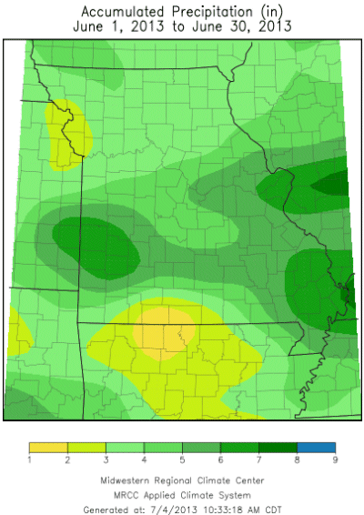
Monthly precipitation was variable across Missouri, but the statewide average was 4.71 inches, or 0.04" above the long-term average. Due to the localized nature of convective activity, precipitation disparities were profound across the state. Regionally, the highest precipitation totals were confined to east central and southeastern sections. Another area of heavier rainfall extended from a 100-mile wide corridor centered in Vernon County, in southwestern Missouri, to Shannon County, in south central sections. Most locations across the northern half of the state received 2-4 inches, whereas the southern half reported 4-6 inches. There were notable exceptions, however.
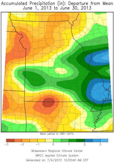
Some of the highest rainfall totals were in Barton, Dade and Greene counties where CoCoRaHS observers reported 10.17, 10.36 and 12.68 inches, respectively. Ironically, driest conditions were also reported in southwestern Missouri, where observers in Stone, Barry and Taney counties reported 1.35, 1.28 and 0.75 inches for the month. As of July 2, there was no official drought designation in the state, Figure 3, but conditions were getting dry in pockets of central Missouri and extreme southwestern sections.
A highly localized and unusual extreme precipitation event impacted portions of southwestern Missouri during the morning and early afternoon hours of June 15. Slow-moving, training thunderstorms developed along an outflow boundary just south of Springfield and dropped intense and extreme rainfall totals ranging from 6-9 inches. Flash flooding quickly emerged across parts of southern Greene County and northern Christian County, with inundated roads and numerous high water rescues reported. The Springfield National Weather Service office issued a flash flood emergency for parts of south Springfield due to the extreme flooding. Intense thunderstorms also dropped heavy rainfall over portions of Jasper and Barton counties during this time, resulting in localized flash flooding.
Severe thunderstorms developed in eastern Kansas late in the evening of June 27 and impacted the Kansas City metropolitan area before sweeping southeastward into parts of west central and south central Missouri during the early a.m. hours of the 28th. There were numerous reports of tree, power line and property damage due to winds gusting between 50 and 70 mph.
According to the Missouri Agricultural Statistics Service, by the end of June crop conditions had improved with warmer weather and scattered showers. Fifty-nine percent of the corn and soybean crop were reported to be in good to excellent condition. More than 90% of the topsoil and subsoil moisture conditions were reported to be in adequate to surplus condition and 76% of the pastures were in good to excellent condition. Hay and stock water supplies were sufficient where 86% and 99%, respectively, were in adequate to surplus condition.
Jump to:
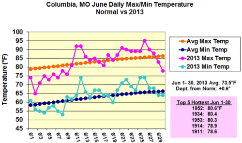
Figure 1
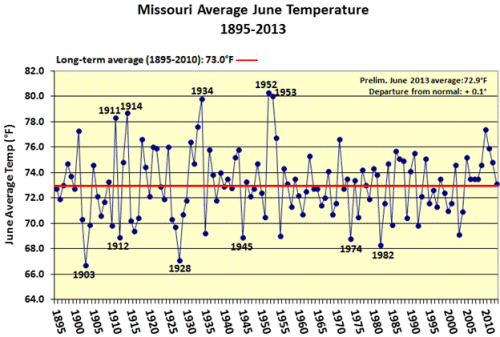
Figure 2
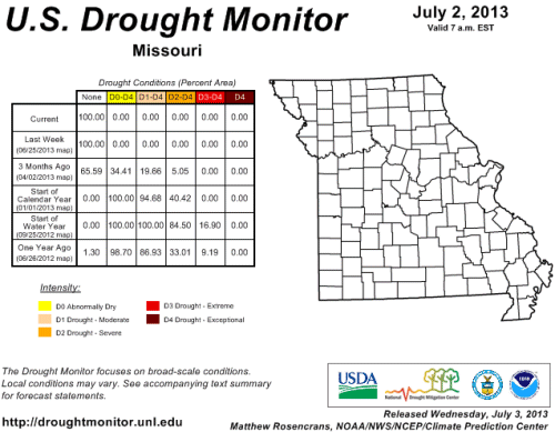
Figure 3