
June 2019 Weather and Its Impacts on Missouri
Pat Guinan
State Climatologist
University of Missouri Extension
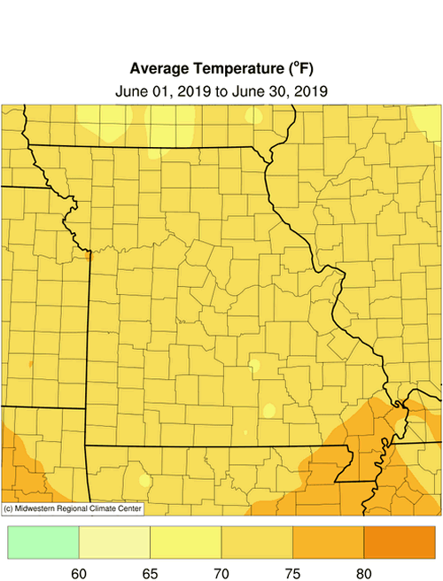
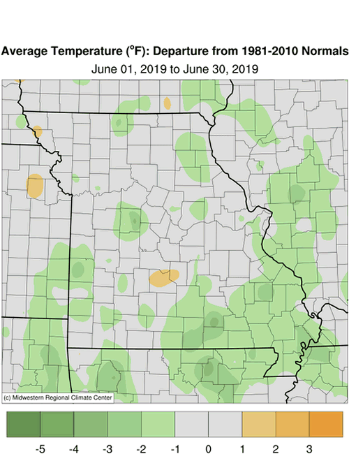
Seasonably cool June temperatures accompanied mostly wet conditions for Missouri with preliminary data indicating a statewide average temperature of 72.4°F, or 0.6 degrees below the long-term average. It was the first cooler than average June in 15 years, and coolest June since 2004, Figure 1. The temperature departures this year have not been erratic compared to last year, Figure 2.
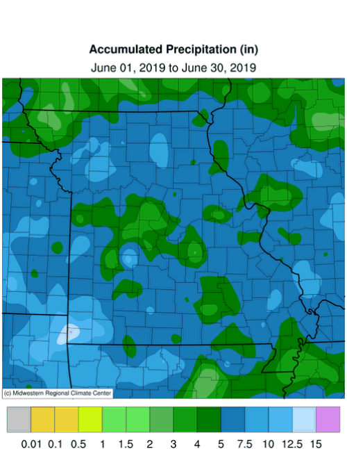
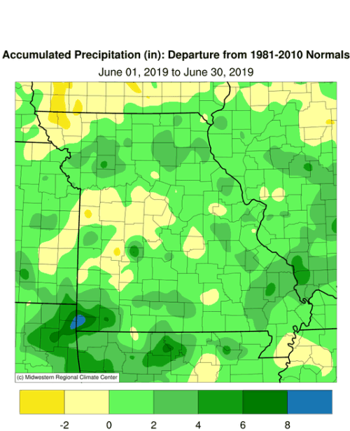
The extreme wetness experienced in May persisted into June with most of the state reporting above average rainfall. Preliminary data indicated the statewide average rainfall total was 5.92 inches, or 1.27 inches above the long-term average. It was the wettest June since 2015, Figure 3, and 8th wetter than average month over the past 11 months, Figure 4. The past two months ranked as the 3rd wettest May-June period on record, and wettest May-June since 1943, Figure 5. The past 12 months (July 2018-June 2019) ranked as the 4th wettest on record, Figure 6.
Some of the heaviest and lightest monthly totals for June are listed in Tables 1 and 2. Parts of McDonald County, in the southwestern corner of the state, reported more than 17 inches for the month and a CoCoRaHS observer from McDonald County, near the community of Anderson, reported a May-June total of 34.24 inches.
| Highest June 2019 Rainfall (in) - NWS and CoCoRaHS Reports | ||
| Location | County | June |
| Anderson 3.2 NNW | McDonald | 17.62 |
| Neosho 3.9 WNW | Newton | 13.44 |
| Cassville | Barry | 12.69 |
| Butler 0.8 SSW | Bates | 11.18 |
| Kingston | Caldwell | 10.82 |
| Carthage | Jasper | 10.78 |
| Table 1. | ||
| Lowest June 2019 Rainfall (in) - NWS Coop and CoCoRaHS Reports | ||
| Location | County | June |
| Tarkio #2 | Atchison | 2.69 |
| Boonville 4 SW | Cooper | 2.97 |
| Maryville 2E | Nodaway | 3.14 |
| Cole Camp 3 NW | Benton | 3.33 |
| Rolla 3 WSW | Phelps | 3.33 |
| Dexter | Stoddard | 3.37 |
| Table 2. | ||
Flooding continued to be a problem during the month with many rivers and streams remaining near and above flood stage. A widespread heavy rain event during the latter half of June, Figure 7, resulted in another crest for many rivers, which re-flooded roads and bottomland acres and stressed levees further.
Frequent rain events during the month made it challenging for farmers to finish planting and cut and bale hay. According to the Missouri Agricultural Statistics Service, for the week ending June 30, 95% of the corn had been planted compared to a 5-year average of 99%. Soybean was 79% planted, compared to a 5-year average of 90%. Topsoil and subsoil moisture supplies were rated 98% and 100% adequate to surplus, respectively. Corn and soybean was rated mostly fair at 45% and 42%, respectively. Pasture conditions were mostly good at 56%. The majority of hay supplies and other roughages were adequate at 67%. Stock water supplies were reported to be in adequate (86%) or surplus (14%) condition.
Missouri was "drought-free" during the last week of June, according to the U.S. Drought Monitor map, Figure 8.
Jump to:
- Figure 1
- Figure 2
- Figure 3
- Figure 4
- Figure 5
- Figure 6
- Figure 7
- Figure 8
- Figure 9
- Figure 10
- Figure 11
- Figure 12
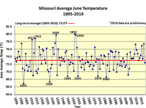
Figure 1.
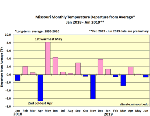
Figure 2.
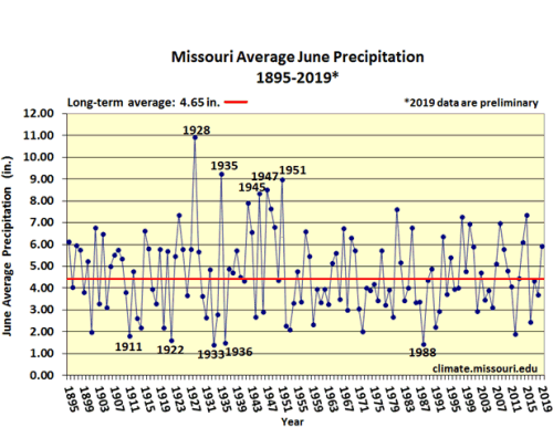
Figure 3.
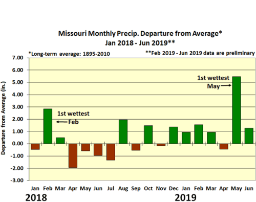
Figure 4.
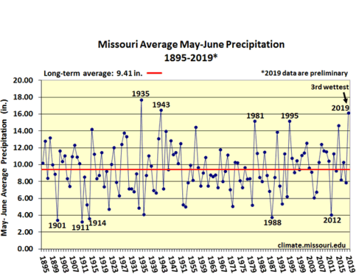
Figure 5.
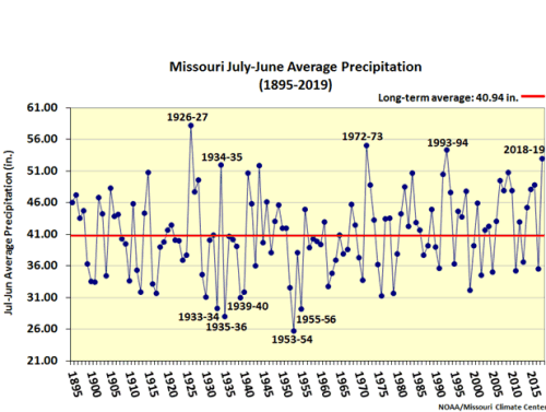
Figure 6.
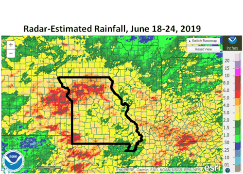
Figure 7.
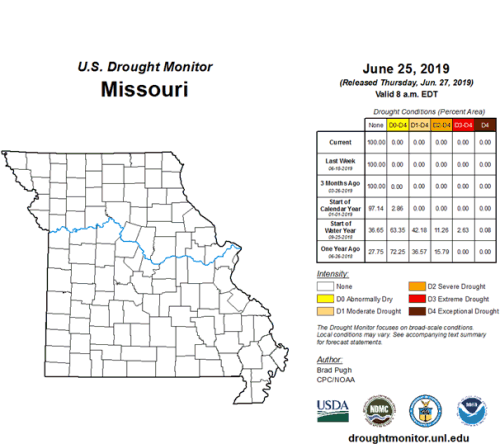
Figure 8.
Source: Pat Guinan, 573-882-5908