
June 2021 Weather and Its Impacts on Missouri
Pat Guinan
State Climatologist
University of Missouri Extension
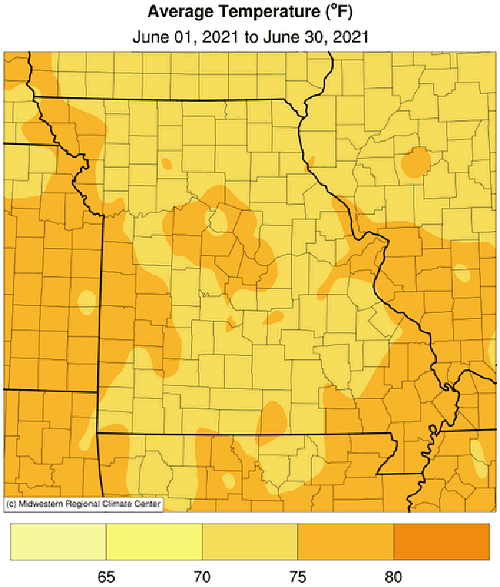
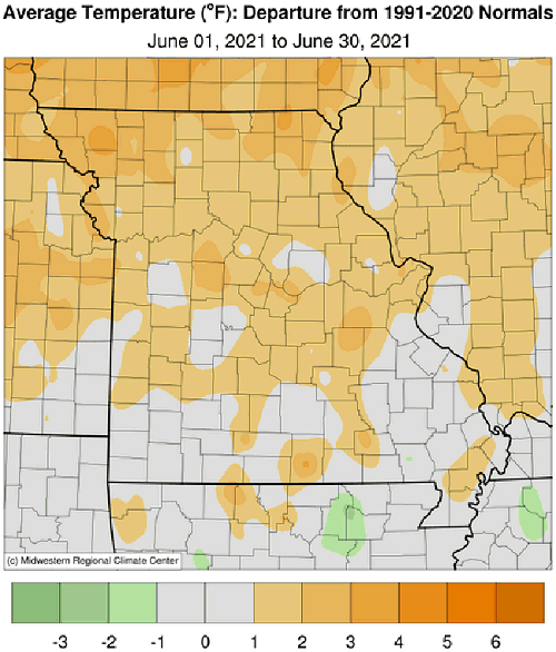
Above average June temperatures were dominant for Missouri, especially during the first 3 weeks of the month, but cooler temperatures toward the end of the month tempered the warm monthly anomaly, Figure 1. Preliminary data indicate a statewide average monthly temperature of 74.6°F, or 1.6 degrees above the baseline average (1901-2000). The warmer than average temperatures followed the trend over the past several years, where only one June since 2005 has been below average, Figure 2. It was also the tenth warmer than average month since January 2020, Figure 3.
Dry and hot conditions emerged during the first few weeks of June and producers were concerned since critical corn growth stages were approaching. However, a pattern change during the third week shifted concerns from impending drought to flooding. The majority of rainfall occurred during the last 12 days of June and a few locations reported their wettest June in decades. Columbia Regional Airport reported 0.10" between June 1-19, but received 10.85 inches for the month, making it the 2nd wettest June since 1890 and wettest June since 1928 when 14.86 inches was reported.
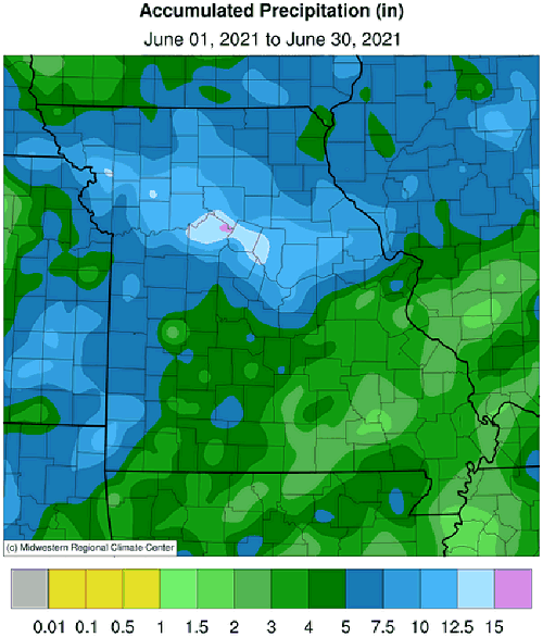
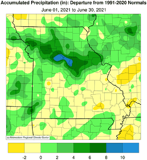
Monthly rainfall was above average statewide, but variable across Missouri, ranging from 10-15+ inches in parts of northwestern and central Missouri to less than 2-inches over portions of southern Missouri, according to radar estimates, Figure 4. The statewide average rainfall total was 6.06 inches, 1.44 inches above the baseline average (1901-2000), Figure 5. June was the fifth month this year with above average precipitation and 12th wetter than average month since January 2020, Figure 6. Some of the heaviest and lightest June rain gauge totals are listed in Tables 1 and 2.
| Highest June 2021 Rainfall (in) - NWS Coop and CoCoRaHS reports | ||
| Location | County |
June |
| Glasgow | Howard | 17.59 |
| Marshall | Saline | 16.01 |
| Harrisburg 5.9SSE | Boone | 15.95 |
| Hardin 0.6WNW | Ray | 15.12 |
| Seneca | Newton | 14.52 |
| Cosby 1.2E | Andrew | 14.26 |
| Kingston 0.1WNW | Caldwell | 13.57 |
| Boonville 0.5ESE | Cooper | 12.94 |
| Oregon 1.3ESE | Holt | 12.74 |
| Waverly | Lafayette | 12.68 |
| Table 1. | ||
| Lowest June 2021 Rainfall (in.) - NWS Coop and CoCoRaHS reports | ||
| Location | County |
June |
| Williamsville | Wayne | 1.26 |
| Van Buren | Carter | 1.86 |
| Washburn 5W | Barry | 2.28 |
| Perryville Water Plant | Perry | 2.36 |
| Alton 1.7NNW | Oregon | 2.37 |
| Charleston 5S | Mississippi | 2.39 |
| Mountain View 7.0NE | Shannon | 2.40 |
| Steele 6W | Pemiscot | 2.57 |
| Washington 4.0S | Franklin | 2.70 |
| Licking 4N | Texas | 2.85 |
| Table 2. | ||
The extraordinary amount of rainfall that fell over parts of the state during the last 12 days of June resulted in thousands of acres of flooded low-lying fields and bottomlands. Nitrogen deficiencies in corn were also reported. Alternatively, pastures had greened up nicely with the cooler temperatures and abundant rainfall.
Wetter conditions toward the end of June resulted in no drought for the Show Me State, according to the U.S. Drought Monitor, Figure 7. There were a couple areas showing abnormally dry conditions, including a few northwestern counties bordering Iowa and a thin corridor in southeastern Missouri, extending from Ste. Genevieve and Perry Counties southwestward to parts of Carter and Shannon Counties.
According to the Missouri Agricultural Statistics Service, for the week ending June 27, 2% of the corn was silking compared to a 5-year average of 15%. Soybean was 96% planted, compared to a 5-year average of 91%. Topsoil moisture supplies were rated 86% adequate to surplus and subsoil moisture was rated at 91% adequate to surplus. Corn was rated mostly good to excellent at 58% and soybean was reported at 57% good to excellent. Pasture conditions were mostly good to excellent at 72%. The majority of hay supplies and other roughages were adequate at 81%. Stock water supplies were reported to be in adequate (85%) or surplus (12%) condition.
Jump to:
- Figure 1
- Figure 2
- Figure 3
- Figure 4
- Figure 5
- Figure 6
- Figure 7
- Figure 8
- Figure 9
- Figure 10
- Figure 11
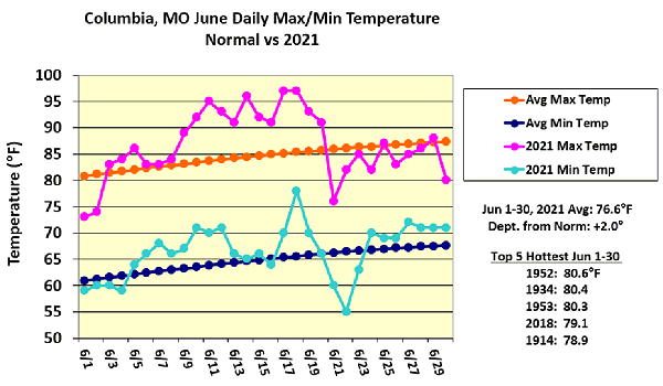
Figure 1.
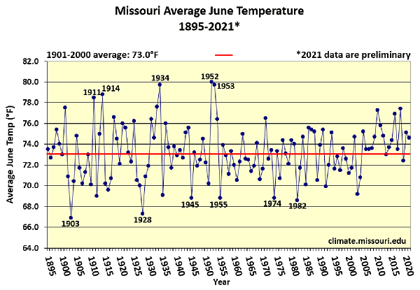
Figure 2.
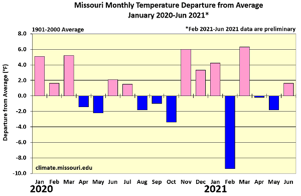
Figure 3.
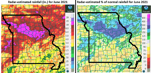
Figure 4.
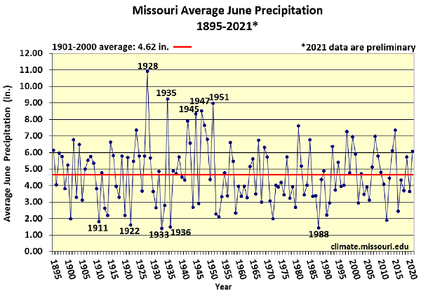
Figure 5.
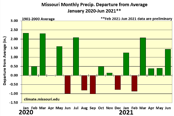
Figure 6.
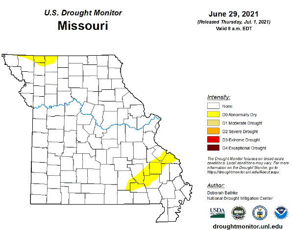
Figure 7.
Source: Pat Guinan, 573-882-5908