
May 2015 Weather and Its Impacts on Missouri
Pat Guinan
State Climatologist
Commercial Agriculture/University of Missouri Extension
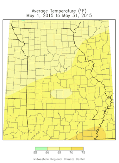
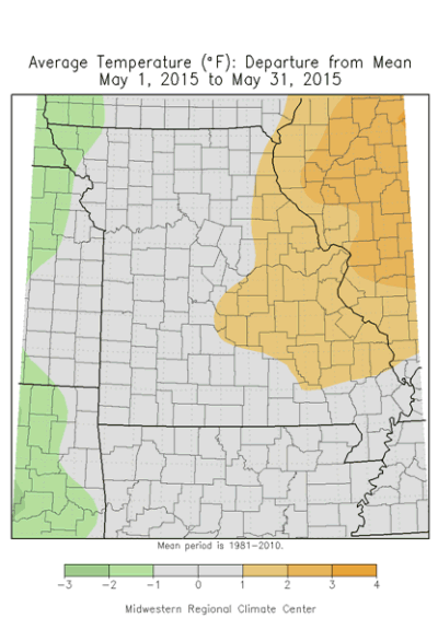
May temperatures were slightly warmer than normal during May with preliminary data indicating a statewide average temperature of 64.8°F, or 0.5° above average, Figure 1. It was the third consecutive above average month for the year, Figure 2, and continued the seasonal trend of mild springs since 2000, Figure 3. Only 4 springs over the past 16 years have been cooler than average. Daily temperatures were variable during the month with warmest conditions occurring the first part of May, and more erratic temperature swings the remainder of the month, Figure 4. Warmest monthly departures occurred over eastern parts of Missouri where temperatures averaged 1-2 degrees above normal. Cooler monthly temperatures, from 0-1 degrees below normal, were confined to portions of western Missouri where wetter and cloudier conditions resided.
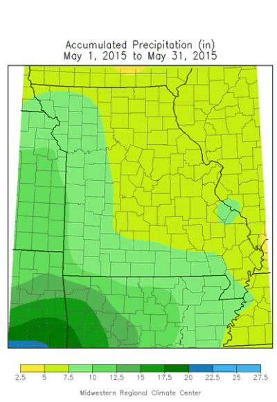
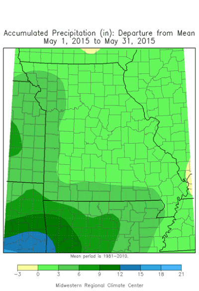
May is climatologically Missouri's wettest month and this year was no exception. Rainfall was well above average with preliminary data indicating an average statewide total of 7.48 inches, or 2.71 inches above normal. It was the wettest May since 2002, and the 13th wettest May on record, Figure 5. Amounts varied across the state, but most locations received more than five inches for the month. Lightest amounts ranged from 4-5 inches and were common over parts of east central Missouri, especially around the St. Louis metropolitan area and few small pockets in north central Missouri. Five to eight inches were reported across much of the rest of the state, and heaviest amounts in excess of 10 inches were reported over several western counties and a few southern locations. Some of the highest reports are listed in Table 1. May reversed a 6-month consecutive trend of below normal precipitation for the state, Figure 6.
The wet conditions limited fieldwork activity and planting opportunities across the state. According to the Missouri Agricultural Statistics Service, 87% of the corn and only 23% of the soybean crop had been planted by the end of May, 8% and 34% behind the 5-year average, respectively. Wettest conditions were in northwestern Missouri where only 67% of the corn had been planted as of May 31. Most of the cotton was in fair condition, still feeling the effects of some cool periods and excessive moisture earlier in the month. The wet weather benefited pastures with 72% of them reported to be in good to excellent condition at the end of May.
The latest summer outlook issued on May 21, 2015 by the Climate Prediction Center indicated an enhanced likelihood of below normal temperatures and above normal precipitation for much of the Show Me State, Figure 7. Another indicator of perhaps what to expect this summer is the relationship between unusually wet Mays and what occurs in regard to following summer temperature and precipitation trends. Figure 8 shows the top 20 wettest Mays in Missouri over the past 120 years and what happened the following summer (Jun-Jul-Aug) with respect to temperature and rainfall anomalies. It is evident summers tend to be more seasonable or cooler as well as experience near average to wetter conditions following an unusually wet May. The rationale behind these occurrences are that May can be considered a transition month into the summer season, where weather patterns in the Midwest tend to be more stagnant. An established or recurring weather pattern in May could stick around for the summer. Additionally, wet soil moisture conditions at the onset of summer can act to suppress maximum temperatures when more of the sun's energy will be used in evaporating available moisture.
| Table 1 | ||||
| Location | County | May 1-31 Rainfall (in) | ||
| 1 | Plattsburg 0.6W | Clinton | 14.00 | |
| 2 | Anderson 6.8W | McDonald | 13.65 | |
| 3 | Gladstone 2.6N | Clay | 13.07 | |
| 4 | Seneca 5.8SSE | Newton | 12.57 | |
| 5 | Carthage 0.8S | Jasper | 12.34 | |
Jump to:
- Figure 1
- Figure 2
- Figure 3
- Figure 4
- Figure 5
- Figure 6
- Figure 7
- Figure 8
- Figure 9
- Figure 10
- Figure 11
- Figure 12
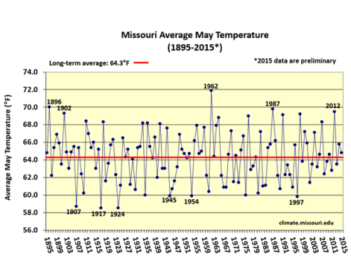
Figure 1.
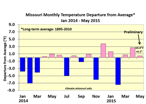
Figure 2.
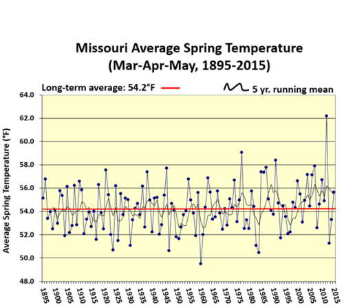
Figure 3.
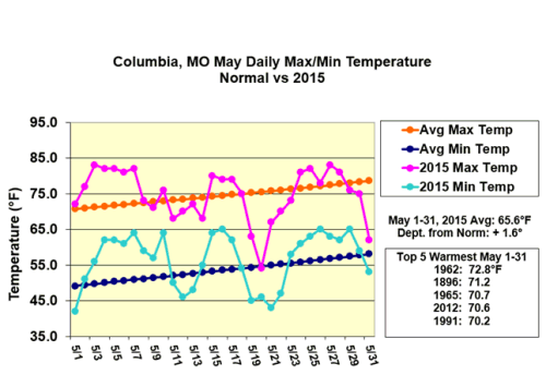
Figure 4.
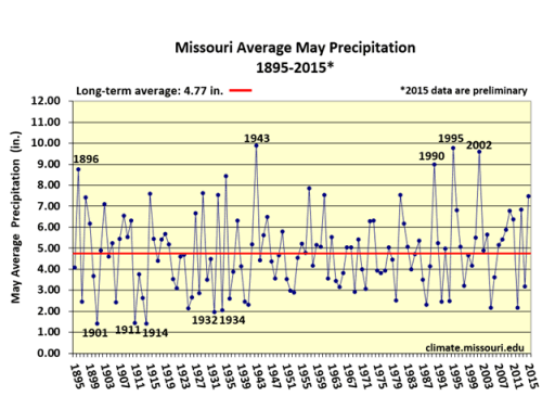
Figure 5.
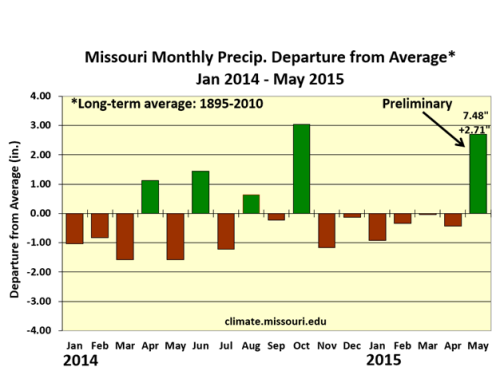
Figure 6.
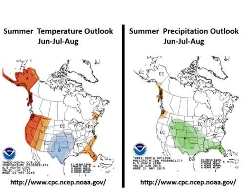
Figure 7.
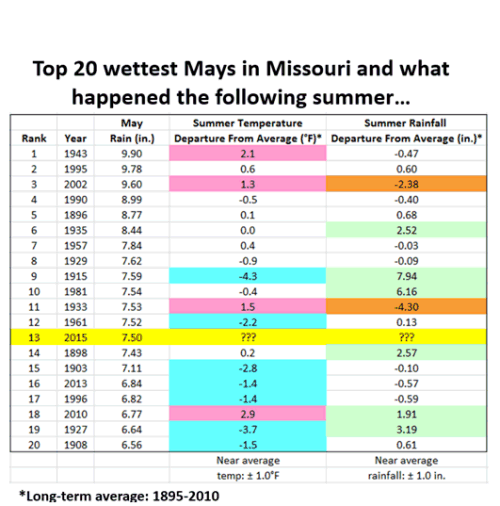
Figure 8.
Source: Pat Guinan, 573-882-5908