
May 2018 Weather and Its Impacts on Missouri
Pat Guinan
State Climatologist
Commercial Agriculture/University of Missouri Extension
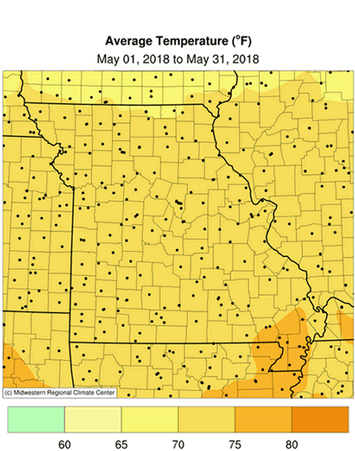
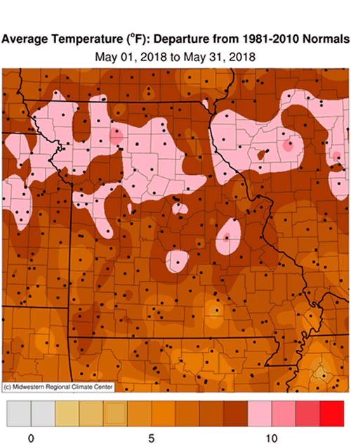
Record May warmth impacted Missouri with preliminary data indicating a statewide average temperature of 72.5°F, or 8.2 degrees above the long-term average. The unprecedented warmth eclipsed the prior record established in 1962, Figure 1. Most locations were above normal every day of the month, Figure 2. A stubborn ridge of high pressure over the middle part of the country resulted in a persistent and unusually warm weather pattern during the month. Numerous states reported their warmest May on record, Figure 3, as well as the contiguous United States.
Several locations in Missouri established daily high temperature records, especially during the last week of May. Highly unusual triple-digit heat was reported in a few northwestern Missouri communities from May 26-28, Table 1.
| Extreme High Temperature Records (NWS Coop and Missouri Mesonet) | |||
| Location | County | Max Temp (°F) | Date |
| Corning* | Atchison | 103 | 26 |
| St Joseph AP | Buchanan | 102 | 26 |
| Albany | Gentry | 101 | 28 |
| Cosby 2W | Andrew | 101 | 28 |
| Maryville 2E | Nodaway | 100 | 28 |
| *Missouri Mesonet weather station | |||
| Table 1. | |||
The extreme flip in monthly temperature anomalies, from 2nd coldest April to 1st warmest May, was nothing short of incredible, Figure 4. Missouri experienced a spring where April behaved more like March and May was typical of June. The last time a flip in extreme temperature anomalies for consecutive months occurred in Missouri was December 1989 (3rd coldest) to January 1990 (3rd warmest), Figure 5.
May 2018 was Missouri’s 6th month in less than 20 years to become the warmest on record, following a February record established in 2017, Figure 6. The last time a record cold month occurred in Missouri was 35 years ago, in December 1983.
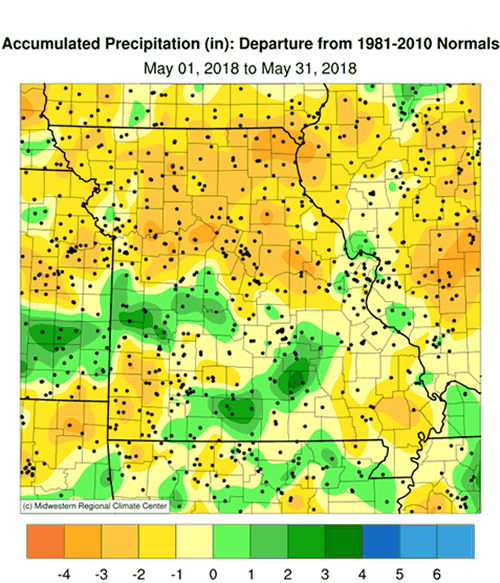
Preliminary precipitation data indicate a statewide average May total of 4.11 inches, or 0.66 inches below the long-term average. It was the first below normal May since 2014, Figure 7, and the second consecutive dry month this spring, Figure 8.
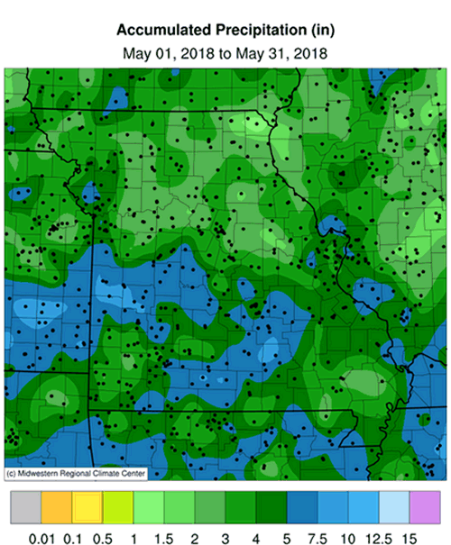
Rainfall was variable across the state with heaviest totals observed across the southern half of Missouri where 4-5 inches were common, Figure 9. Similar amounts were also concentrated around and north of the Kansas City area. Lighter monthly totals, 2-4 inches, were observed over portions of northern and central Missouri and in a few southwestern counties. Driest conditions were found in far northeastern Missouri where a location in Clark County reported less than 1-inch for the month. Highest and lowest monthly rainfall reports are listed in Tables 2 and 3.
| Highest May 2018 Rainfall (NWS Coop and CoCoRaHS reports) | ||
| Location | County | May 1-31 Rainfall (in.) |
| Ava 0.8NNW | Douglas | 9.99 |
| Collins 5.5WNW | St. Clair | 9.88 |
| Round Spring 2SW | Shannon | 9.73 |
| Rich Hill 4.9SE | Bates | 9.66 |
| Cape Girardeau 1.8SE | Cape Girardeau | 9.06 |
| Table 2. | ||
| Lowest May 2018 Rainfall (NWS Coop and CoCoRaHS reports) | ||
| Location | County | May 1-31 Rainfall (in.) |
| Kahoka 0.6S | Clark | 0.87 |
| Memphis 0.1S | Scotland | 1.35 |
| Fayette 7ESE | Howard | 1.42 |
| Concordia | Lafayette | 1.54 |
| Gallatin 1W | Daviess | 1.95 |
| Table 3. | ||
Drought conditions persisted across northern Missouri including a pocket of severe drought impacting portions of DeKalb, Daviess, Clinton and Caldwell Counties, Figure 10. The dryness is intense in some sections with significant deficits accumulating over the past 13 months, Figure 11. The St. Joseph Airport reported 23.13 inches between May 1, 2017 and May 31, 2018; normal is 40.90 inches, Figure 12.
Groundwater across northern Missouri is mineralized and unusable, and residents and livestock rely on surface supplies. Water shortages are occurring, including water restrictions for the communities of Cameron, Hamilton and Milan. The reservoirs at Cameron and Grindstone were reported to be at 49% capacity. Additionally, the soil moisture anomaly indicates a dry soil profile, Figure 13, and row crops are beginning to show signs of drought stress across the driest areas. It is imperative significant rainfall returns soon or conditions will rapidly deteriorate if hot, dry weather continues.
When it comes to assessing drought for your area, all Missouri residents have the opportunity to submit drought impact reports to the National Drought Mitigation Center. A website called the Drought Impact Reporter, http://droughtreporter.unl.edu/, is a resource for submitting reports. In order to contribute impact reports, and provide local expertise to authors of the U.S. Drought Monitor map, participants are encouraged to use the Drought Impact Reporter. Drought impact statements are seen by the Drought Monitor author, as well as the general public, and become archived documentation for future authors to refer to. More participation and input from local Missourians will establish a consensus of opinions among folks and hopefully provide a more accurate portrayal of drought in the Show Me State.
Figure 14 is the latest summer temperature and precipitation outlook (Jun-Jul-Aug) issued by the Climate Prediction Center. The outlook indicates a slightly enhanced likelihood of above normal temperatures over the southwestern tip of Missouri and equal chances of above, below and near normal temperatures for the rest of the state. There is a slightly enhanced likelihood of above normal rainfall anticipated for the northeastern half of Missouri, and equal chances for above, below and near normal precipitation for the rest of the state.
Jump to:
- Figure 1
- Figure 2
- Figure 3
- Figure 4
- Figure 5
- Figure 6
- Figure 7
- Figure 8
- Figure 9
- Figure 10
- Figure 11
- Figure 12
- Figure 13
- Figure 14
- Figure 15
- Figure 16
- Figure 17
- Figure 18
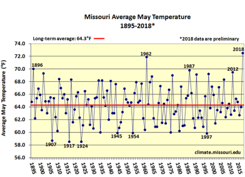
Figure 1.
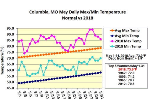
Figure 2.
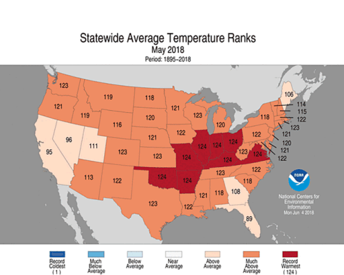
Figure 3.
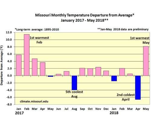
Figure 4.
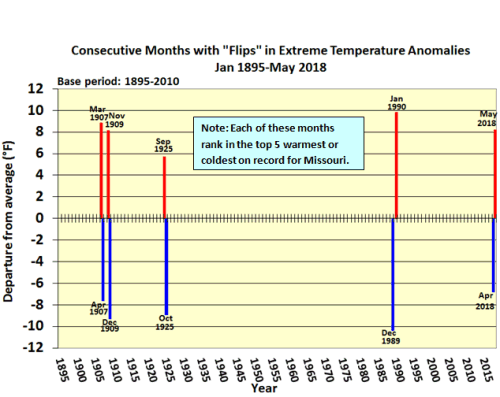
Figure 5.
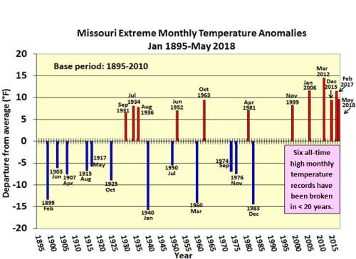
Figure 6.
Figure 7.
Figure 8.
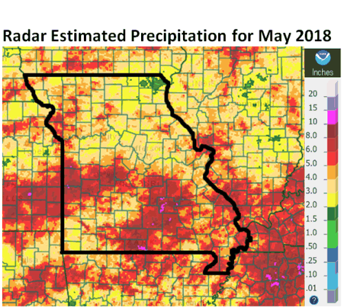
Figure 9.
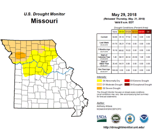
Figure 10.
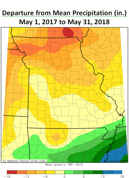
Figure 11.
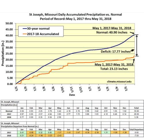
Figure 12.
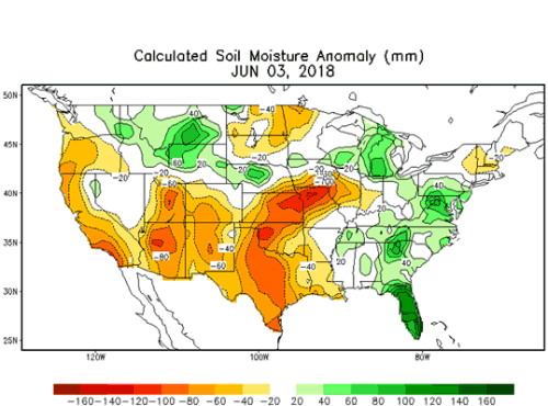
Figure 13.
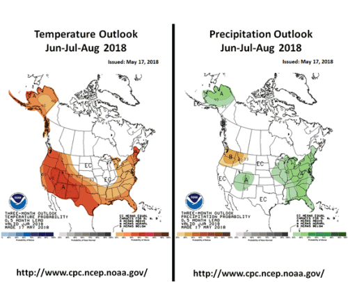
Figure 14.
Source: Pat Guinan, 573-882-5908