
May 2020 Weather and Its Impacts on Missouri
Pat Guinan
State Climatologist
University of Missouri Extension
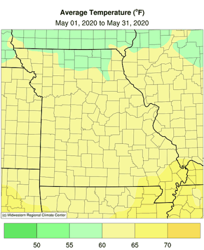
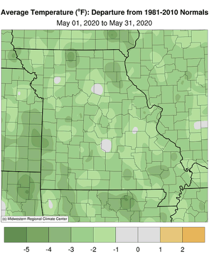
Seasonably cool temperatures were the rule in Missouri during May, especially with maximum daily temperatures, Figure 1. Preliminary data indicate the statewide average temperature was 61.9°F, or 2.4° below the long-term average. It was the coolest May in nearly two decades, or since 2002, Figure 2. April and May temperatures were below average this year, an unusual occurrence considering the past few decades. It was the coolest April-May period since 2008 and only the fifth time since 1998 with below normal temperatures for the two-month period, Figure 3. It was the first cooler than average consecutive months since last fall when October and November were below average, Figure 4.
Unusually cool minimum temperatures, some at or below freezing, occurred on May 9 and 11 with frost reported in many locations, Figure 5. Lowest temperatures at some locations during these dates were at or below 30°F, Table 1. Several long-term low temperature records were broken including Columbia (36°F on May 11), Kansas City (34°F on May 9), and Vichy-Rolla (36°F on May 9).
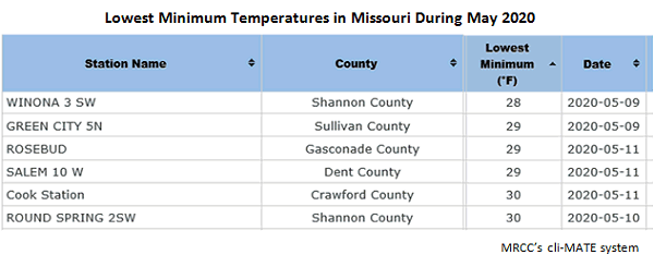
Table 1.
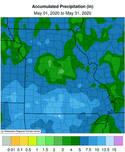
May precipitation was variable across Missouri but averaged above normal for the state. Preliminary data indicate a statewide average total of 6.19 inches, or 1.42 above the long-term average. The wet conditions mimic the trend over the past 30 years, where only ten Mays since 1991 have been drier than average, Figure 6. Wetter than normal months have been dominant since the beginning of last year, Figure 7.
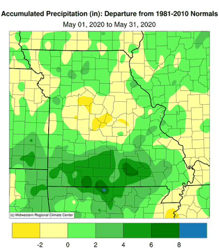
May precipitation varied across the Show Me State, ranging from less than 3-inches in some central and west central counties to more than a foot over portions of the Ozarks, Figure 8. Some of the highest and lowest monthly totals are listed in Table 2.
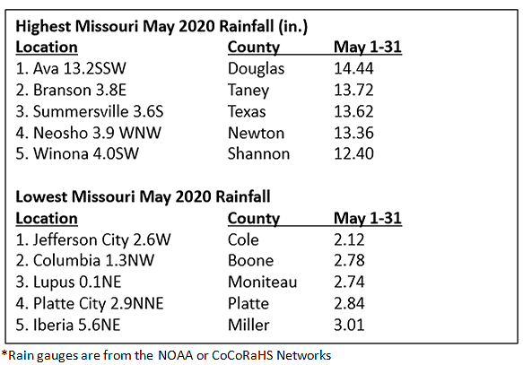
Table 2.
Slow moving upper level lows resulted in extended periods of cloudy weather during the month, especially between May 12-22. Using solar radiation records for Columbia, MO, it was the lowest solar May since 2013, Figure 9.
An unsettled weather pattern resulted in a couple widespread severe weather events for Missouri, on May 3-4, with numerous reports of large hail and straight-line wind damage, mostly impacting west central and southern sections, Figure 10. According to the Storm Prediction Center, there were 185 severe storm reports in Missouri during May, Figure 11.
According to the Missouri Agricultural Statistics Service, as of May 31, 2020, 92% of the corn and 49% of the soybean crop had been planted; the 5-year average is 90% and 49%, respectively. The cool, cloudy weather generally benefited pastures with 64% of them reported to be in good to excellent condition.
Jump to:
- Figure 1
- Figure 2
- Figure 3
- Figure 4
- Figure 5
- Figure 6
- Figure 7
- Figure 8
- Figure 9
- Figure 10
- Figure 11
- Figure 12
- Figure 13
- Figure 14
- Figure 15
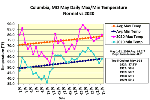
Figure 1.
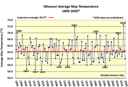
Figure 2.
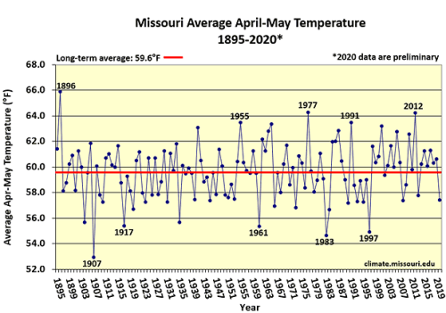
Figure 3.
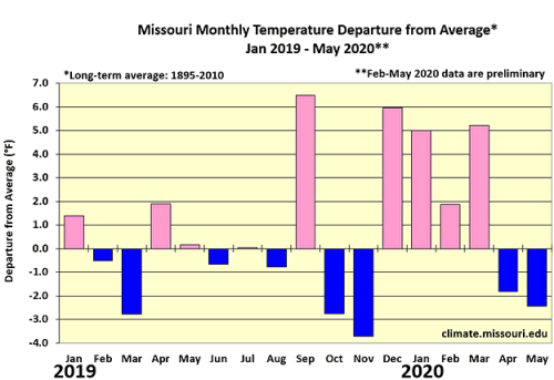
Figure 4.
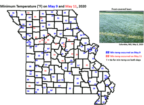
Figure 5.
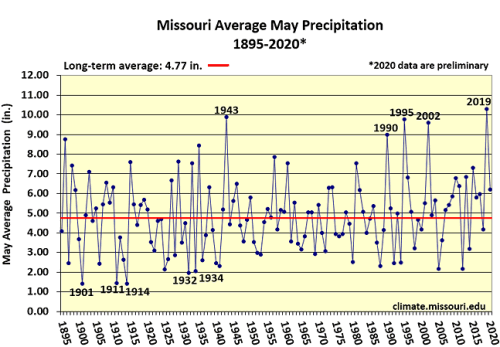
Figure 6.
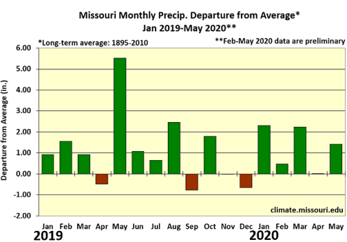
Figure 7.
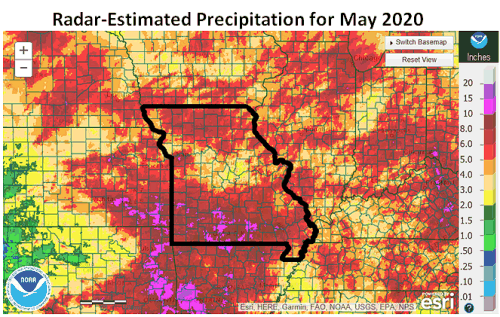
Figure 8.
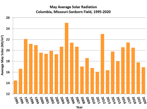
Figure 9.
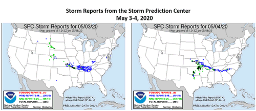
Figure 10.
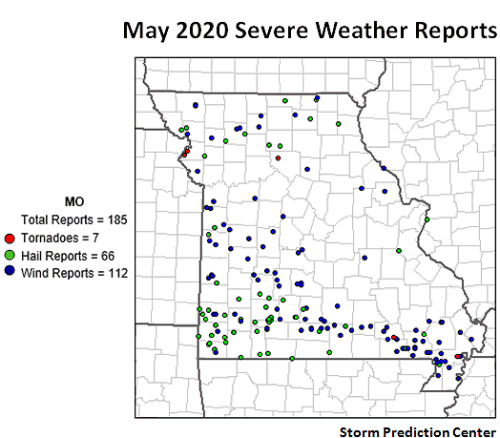
Figure 11.
Source: Pat Guinan, 573-882-5908