March 2011 Weather and Its Impacts on Missouri
Pat Guinan
State Climatologist
Commercial Agriculture/University of Missouri Extension
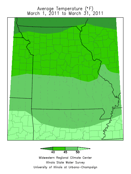
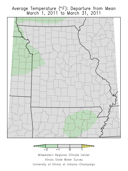
March weather in Missouri was variable with winter cold and snowstorms to spring warmth and thunderstorms. Ironically, the roller coaster behavior of temperatures resulted in near normal temperatures for the month. Specifically, monthly temperatures averaged less than one degree above normal over most of the state with the exception of far northwestern sections where averages were less than one degree below normal.
A progressive weather pattern during the month, as well as numerous frontal systems sweeping through the state, led to frequent periods of cool, cloudy and unsettled weather followed by mild, clear and pleasant conditions. One of the more notable weather events was a late season snowstorm that impacted portions of central Missouri on March 13-14. A band of 3-6 inches of snow, and locally heavier amounts, fell from St. Clair and Benton Counties northeastward to Boone and Cole Counties and then eastward along I-70 to St. Louis. Some of the heaviest snowfall totals were reported in Callaway County where 9-10 inches were observed in and around Fulton, MO.
Another localized and early spring snowstorm impacted portions of central and east central Missouri on March 26th and dropped 2-5 inches of snow from Sedalia eastward through Columbia and Jefferson City to St. Louis. Some of the heaviest totals were reported in portions of Osage, Gasconade and Franklin counties where 6-7 inches were reported.
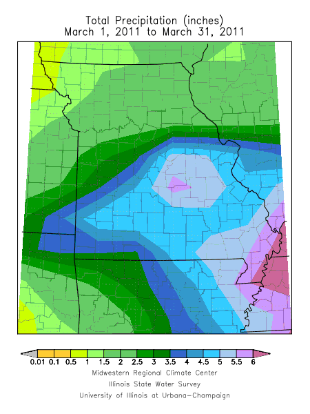
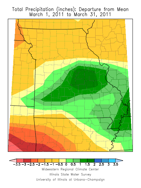
According to preliminary data, the statewide precipitation total for the month was near normal and averaged a little over 3.5 inches. Regionally, March precipitation averaged below normal across northern and west central Missouri as well as a few counties in far southwestern Missouri. Above normal precipitation occurred over most of central, east central, and southern Missouri.
Specifically, northern and west central Missouri reported between 1-2 inches of precipitation and central, east central and southern Missouri observed between 3.5-5.5 inches. Some of heaviest monthly totals were reported in a 30-60 mile wide corridor along Interstate 44, from Joplin to St. Louis, where 5.5-6.5 inches were common. Similar amounts also fell in the Bootheel. Lowest totals were confined to far northwestern and northeastern sections where a few communities reported less than 1-inch of precipitation. The community of Rockport, MO, in Atchison County, received a paltry 0.51 inches for the month.
By the end of the month, snowfall totals for the season beginning July 1 were running much above normal to near record amounts in the state. Columbia reported 53.4 inches for the season, which was 1.6 inches short of the all-time record 54.9 inches set in 1977-78. Some snow season statistics for other locations in the state include:
| Kansas City | 36.9 inches | 9th snowiest |
| St. Louis | 36.8 inches | 6th snowiest |
Much above normal temperatures during the third week of March initiated some growth in early spring vegetation. A quick transition toward much colder weather during the last week may have contributed to some freeze injury to the more vulnerable plants, where some locations reported low temperatures in middle 20's. The average first date for the last 32° temperature ranges from the around the 3rd week of April in northern sections and the Ozarks, to mid-April in central Missouri, and the first week of April in the Bootheel.
With the exception of parts of northern Missouri, spring tillage was running behind schedule across much of the state due to frequent precipitation events during the month and very cool weather that impacted the state during the last week of March.