
February 2016 Weather and Its Impacts on Missouri
Pat Guinan
State Climatologist
Commercial Agriculture Program/University of Missouri Extension
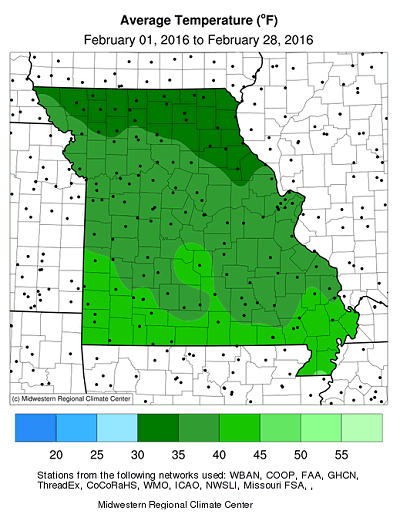
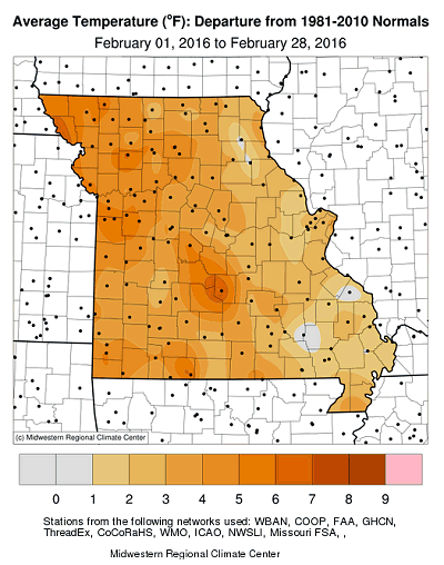
Mild February temperatures were dominant in Missouri with only a handful of days notably colder than average, Figure 1. Preliminary data indicate a statewide average monthly temperature of 37.8°F, slightly more than 4 degrees above normal. It was the mildest February since 2012, Figure 2, and the 6th consecutive month with warmer than normal weather, Figure 3. Preliminary data also indicates this past winter tied with the winter of 1997-98 for being the 7th warmest winter on record, Figure 4.
Several locations reported days with record high temperatures, most notably from February 18-21, when the mercury climbed into the 70's. The highest temperature for the month was 81° on 2/21 and reported by a NWS cooperative observer near Eminence in Shannon county. Coldest temperatures for the month dropped to single digits across parts of the state and were mostly observed on 2/13 and 2/14. There were no sub-zero temperatures reported.
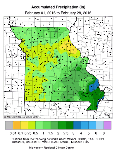
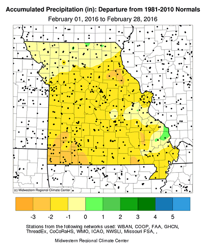
The year remained dry with below normal precipitation reported across the state. Preliminary data indicates a statewide average total of 1.00 inch for the month, which is a little more than one inch below normal. It was the driest February since 2006, Figure 5, and the second consecutive dry month, Figure 6. The Jan-Feb 2016 statewide precipitation average was 1.88 inches (44% of normal), making it the 6th driest Jan-Feb on record, and driest Jan-Feb since 1983, Figure 7.
Heaviest monthly precipitation fell over southeastern Missouri where 1.5-3 inches were common. Driest areas were located over west central, southwestern and parts of northeastern Missouri where 0.25-.50" were typical. Springfield and Joplin reported their 3rd (0.36") and 7th (0.37") driest February on record, respectively. Some of the lowest monthly totals were reported in northeastern Missouri and include Vandalia, (.12"), Shelbyville (.13"), Palmyra (.16") and Monroe City (.18").
The dry, mild weather provided few opportunities for significant snow events. Most locations reported below normal snowfall, with less than 1-inch reported across the western half of the state and far southern Missouri. Parts of east central Missouri and the eastern Ozarks reported heavier snowfall totals due mostly to a storm system on 2/24 that dropped 2-6 inches in a 60-mile wide corridor from Howell to St. Louis counties. Heaviest monthly snowfall totals ranged from 6-9 inches in a small pocket of east central Missouri, including Franklin, Iron, Jefferson, Perry, St. Francois, St. Louis and Washington counties, and St. Louis City.
The mild winter weather translated to substantial savings in heating bills for consumers, but drier conditions in combination with mild temperatures, low humidity and windy days during February resulted in numerous reports of grass fires across the state.
Jump to:
- Figure 1
- Figure 2
- Figure 3
- Figure 4
- Figure 5
- Figure 6
- Figure 7
- Figure 8
- Figure 9
- Figure 10
- Figure 11
- Figure 12
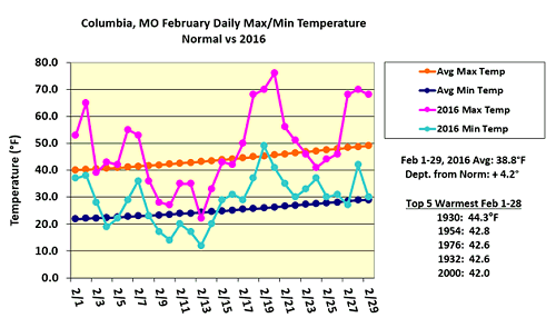
Figure 1.
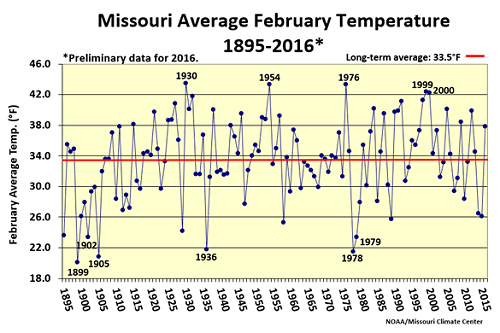
Figure 2.
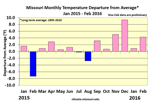
Figure 3.
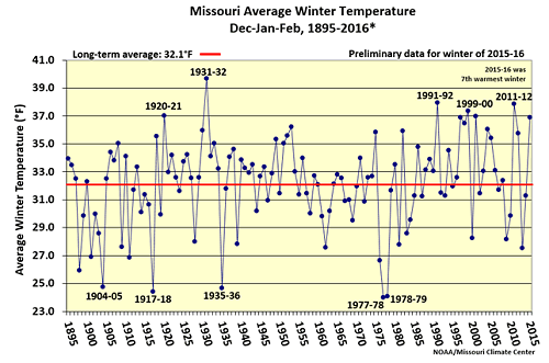
Figure 4.
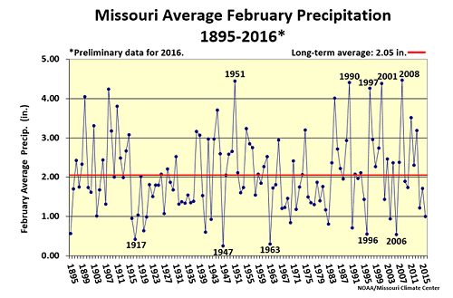
Figure 5.
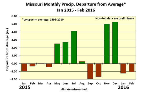
Figure 6.
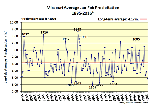
Figure 7.
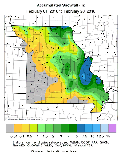
Figure 8.
Source: Pat Guinan, 573-882-5908