
February 2017 Weather and Its Impacts on Missouri
Pat Guinan
State Climatologist
Commercial Agriculture/University of Missouri Extension
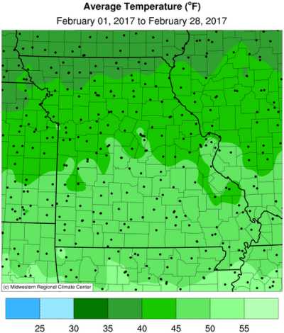
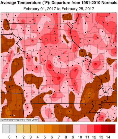
Unprecedented February warmth impacted Missouri in 2017 with record breaking temperatures occurring throughout the state. A zonal to southwesterly upper air flow pattern occurred for much of the month, allowing few opportunities for northern cold air invasions. Preliminary data indicate a statewide average temperature around 45°F, more than 11 degrees above normal, and eclipsing the previous record warmth established in February 1930, Figure 1.
Monthly warm departures of 10 degrees or higher are rare in Missouri, having only occurred 4 times since 1895, i.e. March 1910, January 2006, March 2012 and February 2017. Missouri has broken five monthly extreme temperature records since 1999, all occurring during the cold season, Figure 2. The average February temperature this year was 1.4°F warmer than the long-term average temperature for March in Missouri.
Several locations in Missouri set multiple daily high temperature records, including Columbia, Springfield and Kansas City with 5, 4 and 3 daily records broken, respectively. Springfield climbed to 84°F on Feb 23 and tied the all-time high temperature for the month, which last occurred on Feb 1, 1911. Other records around the state include the most number of days reaching 60°F or higher and 70°F or higher. For example, Columbia was ≥60°F for 15 days and ≥70°F for 9 days, Figure 3, surpassing the previous records of 13 days and 6 days, respectively, established in February 1976.
An incredible 8-day warm spell, beginning Feb 16, acted to spur some vegetation to come out of dormancy and initiate a growing season that was 3-4 weeks ahead of schedule. Several tree varieties flowered, leading to high pollen counts and an early start to the allergy season. Crocuses, daffodils, forsythias and other plant species were blooming with some magnolia trees blooming as far north as central Missouri before the end of the month. Bradford pears and crabapples were blooming across southern Missouri. Concern among fruit crop producers was growing due to the climatological likelihood of a hard freeze to occur well into March, Figure 4. A guide to spring frost/freeze probabilities for Missouri can be accessed at the following link:
Missouri Frost Freeze Probabilities Guide
http://ipm.missouri.edu/frostfreezeguide/
Preliminary winter temperature data (Dec-Jan-Feb) indicates the mild spell, which began in January, was enough to counter cool December weather and rank the season in the top five warmest winters on record, Figure 5. It was the second consecutive unusually mild winter, and has followed an overall warm period that began in the fall of 2015, Figure 6.
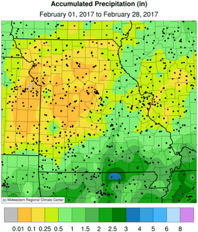
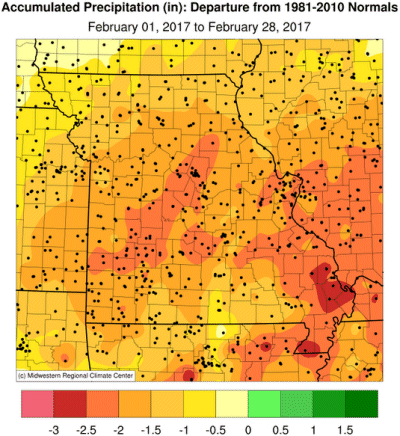
The winter remained dry with much below normal precipitation reported across the state in February. Preliminary data indicates a statewide average total of 0.50 inches for the month, which is 1.55 inches below normal and the 4th driest February on record, Figure 7. It was similar to dryness experienced in Feb 2006, and, if preliminary data verifies, Feb 2017 will be the driest Feb since 1963. It was the 5th consecutive dry month for Missouri, Figures 8 and 9, and the driest Oct-Feb period since 1963-64. The Oct 2016-Feb 2017 statewide precipitation average was 7.40 inches, which is 59% of the long-term average, and 5.20 inches below the long-term average (1895-2010).
Heaviest monthly precipitation fell over far southern and southeastern Missouri where 1-2 inches were common. Driest areas were located over northern and central sections, where many locations reported less than 0.5 inches. Numerous observers in west central Missouri reported less than 0.1 inches for the month.
The multi-month dryness resulted in much of the state experiencing abnormally dry to moderate drought conditions, according to the Drought Monitor map at the end of February, Figure 10. The unusual February warmth hastened dryness impacts with higher than usual evaporative loss and some plant species coming out of dormancy. Currently, water resources above and below the ground are in need of recharge. Agricultural interests are well aware of the unusual dryness as planting season rapidly approaches.
The dry, mild February weather resulted in little to no snowfall in Missouri, Figure 11. Significant portions of the Midwest are running 10-20 inches below normal for the snowfall season, Figure 12. The winter warmth translated to substantial savings in heating bills for consumers, but drier conditions in combination with mild temperatures, low humidity and windy days during February resulted in many grass fire incidents across the state.
A significant severe weather event occurred during the evening and overnight hours of Feb 28-Mar 1 with many reports of hail and wind across central and southern Missouri, Figure 13. A few tornadoes were also reported across central and southern Missouri with a strong, deadly tornado impacting Perry county during the evening hours of Feb 28. Sadly, one fatality and 12 injuries were reported with this tornado. The fatality occurred when an I-55 southbound vehicle near Perryville was intercepted by the tornado. The following analysis and storm survey summary was performed by the National Weather Service office in Paducah, KY.
| Tornado - Perryville, MO, Perry County, Missouri; Jackson and Franklin Counties, Illinois | |
| Date | 2/28/2017 |
| Time (CST) | 7:55 PM - 8:57 PM |
| EF Rating | EF-4 |
| Est. Peak Winds | 180 mph |
| Path Length | 50.4 miles |
| Max Width | 0.6 miles |
| Inujuries/Deaths | 12/1 |
| Summary: Tornado touched down 4.8 miles WNW of Perryville, MO and lifted 1.8 miles SW of Christopher, IL. Some of the worst damage was just northwest of Perryville where 5 homes were leveled. Damage path showed multiple vortex characteristics with ground striations/scarring to bare ground in Perry County near Mississippi River. This is the longest tornado track in the Paducah NWS forecast area since April 22, 1981. | |
Jump to:
- Figure 1
- Figure 2
- Figure 3
- Figure 4
- Figure 5
- Figure 6
- Figure 7
- Figure 8
- Figure 9
- Figure 10
- Figure 11
- Figure 12
- Figure 13
- Figure 14
- Figure 15
- Figure 16
- Figure 17
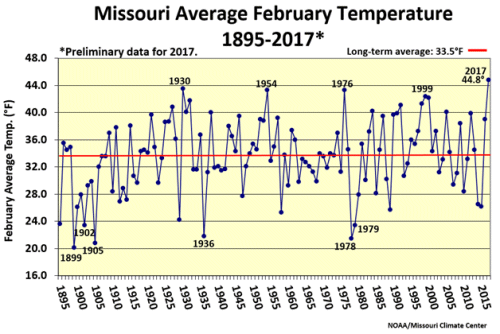
Figure 1.
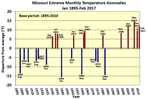
Figure 2.
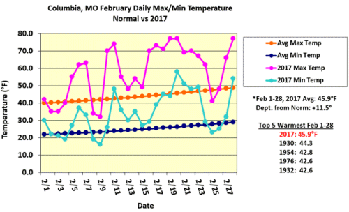
Figure 3.
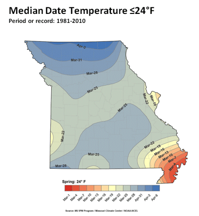
Figure 4.
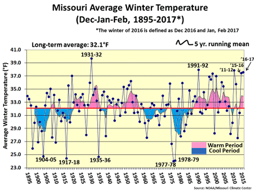
Figure 5.
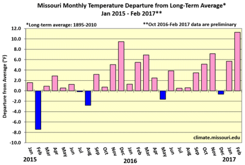
Figure 6.
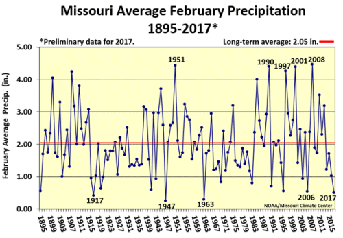
Figure 7.
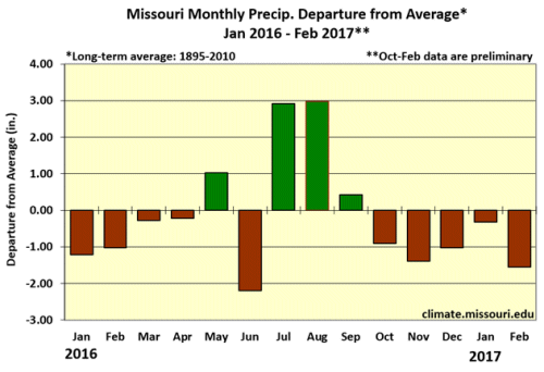
Figure 8.
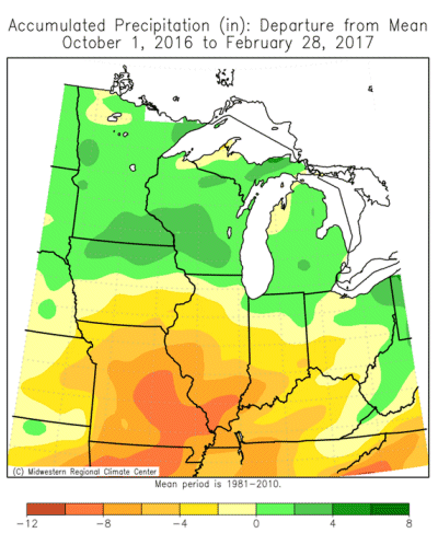
Figure 9.
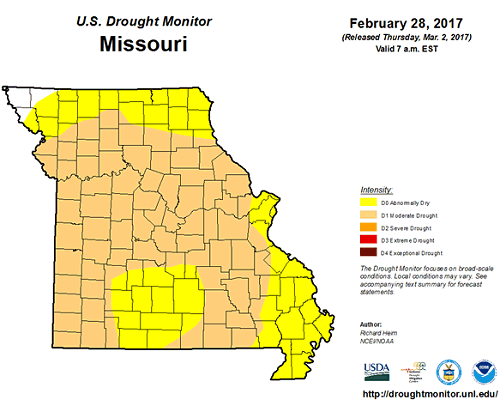
Figure 10.
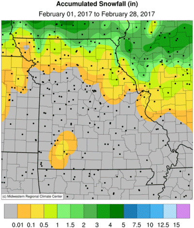
Figure 11.
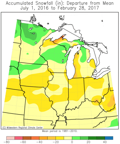
Figure 12.
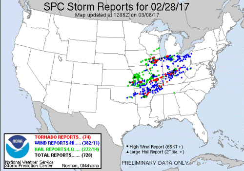
Figure 13.
Source: Pat Guinan, 573-882-5908