
February 2018 Weather and Its Impacts on Missouri
Pat Guinan
State Climatologist
Commercial Agriculture/University of Missouri Extension
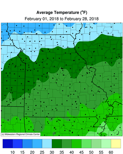
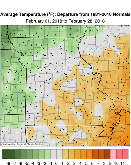
The roller coaster temperature fluctuations, that have been prevalent across Missouri for the winter season, persisted into February. Cold temperatures were dominant from Feb 1-13, averaging 4 to 9 degrees below normal, Figure 1, but transitioned to a mild spell during the remainder of the month, averaging 2 to 7 degrees above normal, Figure 2. Preliminary data indicate the statewide average temperature for the month was 34.6°F, or 1.1 degrees above the long-term average. It was the third consecutive warmer than average February for the state, Figure 3, and the fifth above average month out of the past six months, Figure 4.
The erratic temperature swings over the past 3 months translated to a “near normal” winter season. Preliminary temperature data from Missouri indicate an average temperature for the Dec-Jan-Feb period was 32.4°F, or 0.3 degrees above the long-term average, Figure 5.
With spring around the corner, farmers and gardeners are likely thinking about planting. University of Missouri Extension, in collaboration with MU Integrated Pest Management, developed a Missouri Frost Freeze Probabilities Guide. Median dates for the last hard freeze in Missouri (≤24°F) range from March 4 to April 3, Figure 6.
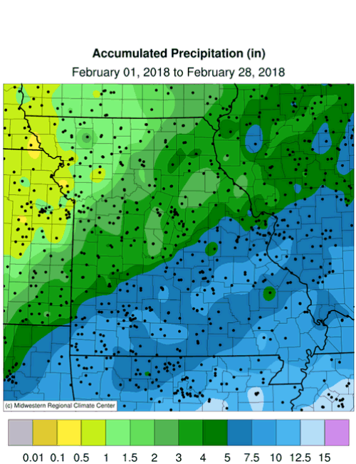
A significant weather pattern change during the latter half of February resulted in exceptionally wet conditions across Missouri, especially over the southeastern third of the state where 5-10 inches of rain were reported, Figure 7. The majority of rainfall occurred during a 6-day period from Feb 19-24. The extreme amounts during this period contributed toward the month being the wettest February on record for the state, Figure 8. Preliminary precipitation data indicate a statewide average total of 4.77 inches, more than 2.7 inches above the long-term average, or 232% of normal. Four out of the top 5 wettest Februaries have occurred since 1990. It was the first wetter than average month since October 2017, Figure 9. Table 1 lists some of the heaviest totals observed during the month, and were mostly confined to the Missouri Bootheel.
| February 2018 Heaviest Precipitation Reports (NWS Coop, Mesonet, CoCoRaHS) | ||
| Location | County | Rainfall (in.) |
| Steele 6W | Pemiscot | 12.54 |
| Poplar Bluff 4.2NW | Butler | 12.30 |
| Cardwell | Dunklin | 11.94 |
| Senath | Dunklin | 11.52 |
| Jackson 1.0SW | Cape Girardeau | 10.74 |
| Table 1. | ||
The exceptional wetness was a “drought buster” for some of the driest areas of the state. According to the U.S. Drought Monitor map, moderate to extreme drought conditions were eliminated over most of east central and southern Missouri by the end of the month, Figures 10-11.
The most notable improvement in drought-stricken locations involved surface water supplies. There were numerous reports of near to complete recovery for rivers, streams and ponds, Figures 12 and 13. Central and southern Missouri also had no frost line during the wet period, and the soil profile experienced significant recharge.
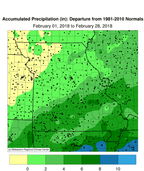
The unprecedented February wetness flipped winter precipitation departures from negative to positive. Preliminary data indicate a statewide average Dec-Jan-Feb total of 7.41 inches for the month, or 0.89 inches above the long-term average, Figure 14.
A severe weather event occurred in the Missouri Bootheel on February 24 when a tornado touched down in Arkansas and crossed the state line impacting Dunklin County, MO. Another tornado was reported in New Madrid County a short time later. Storm survey information from the National Weather Service is listed below.
| Tornado #1 – 2.2 miles southwest of Knobel, AR to Malden, MO | ||
| Date | 2/24/2018 | |
| Time (CST) | 5:25 PM - 6:10 PM CST | |
| EF Rating | EF-2 | |
| Est. Peak Winds | 115 mph | |
| Path Length | 41.5 miles | |
| Max Width | 150 yards | |
| Inujuries/Deaths | 5/1 | |
| Summary: One fatality was reported east of Knobel, AR near the intersection of Hwy 90 and Hwy 135, in a mobile home. A number of homes were damaged in Malden, MO. The path was intermittent. Source: NWS – Memphis, TN | ||
| Tornado #2 - Matthews, Missouri, New Madrid County | |
| Date | 2/24/2018 |
| Time (CST) | 6:30 PM - 6:33 PM CST |
| EF Rating | EF-2 |
| Est. Peak Winds | 120 mph |
| Path Length | 1 mile |
| Max Width | 150 yards |
| Inujuries/Deaths | 2/0 |
| Summary: A NWS storm survey revealed that EF-2 tornado damage occurred from the south side of Matthews, MO to 1 mile east of town. There were dozens of homes with roofs partially or completely torn off. Some semi-trucks were blown over and destroyed, and numerous buildings destroyed. A few injuries occurred due to windows being blown out of a rest home. Source: NWS – Paducah, KY | |
Jump to:
- Figure 1
- Figure 2
- Figure 3
- Figure 4
- Figure 5
- Figure 6
- Figure 7
- Figure 8
- Figure 9
- Figure 10
- Figure 11
- Figure 12
- Figure 13
- Figure 14
- Figure 15
- Figure 16
- Figure 17
- Figure 18
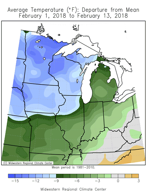
Figure 1.
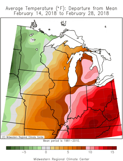
Figure 2.
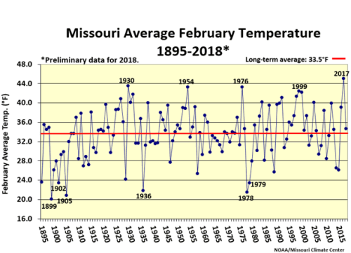
Figure 3.
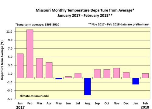
Figure 4.
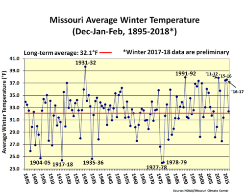
Figure 5.
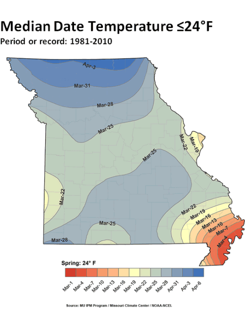
Figure 6.
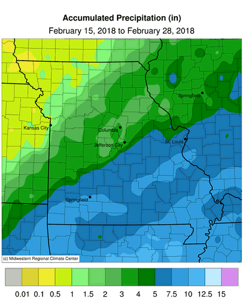
Figure 7.
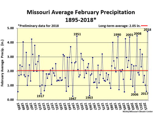
Figure 8.
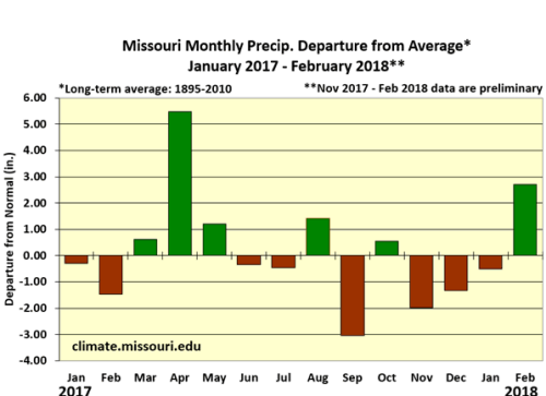
Figure 9.
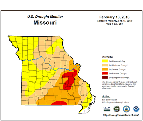
Figure 10.
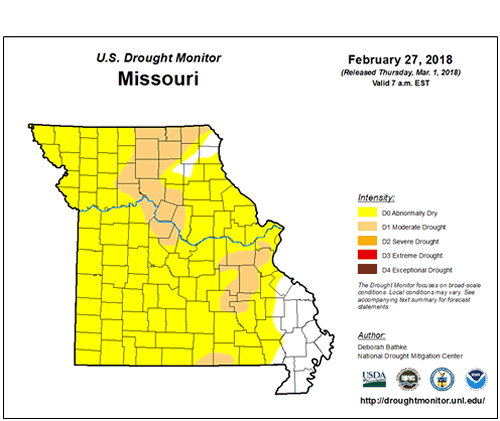
Figure 11.
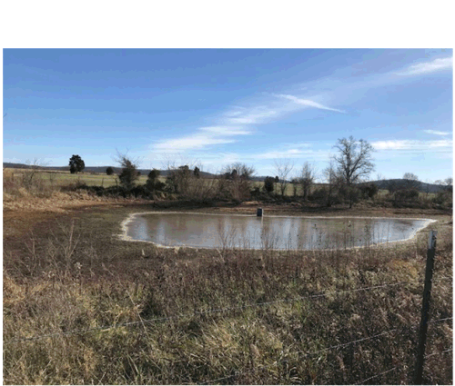
Figure 12. St. Francois County, Missouri, December 10, 2017. Photo taken by Kendra Graham, Extension Livestock Specialist
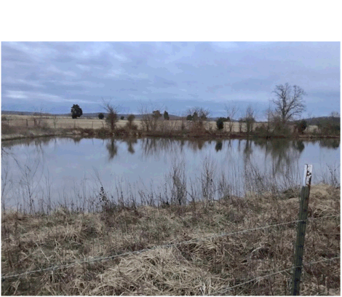
Figure 13. St. Francois County, Missouri, February 28, 2018. Photo taken by Kendra Graham, Extension Livestock Specialist
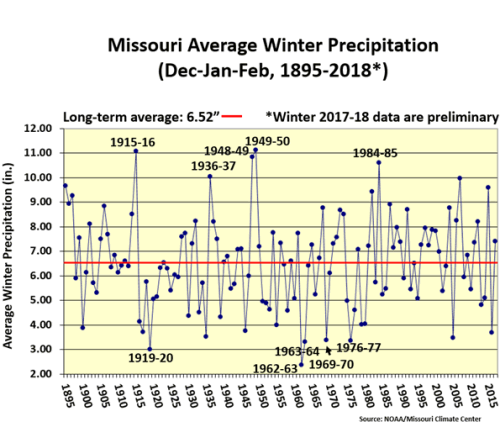
Figure 14.
Source: Pat Guinan, 573-882-5908