
February 2020 Weather and Its Impacts on Missouri
Pat Guinan
State Climatologist
University of Missouri Extension
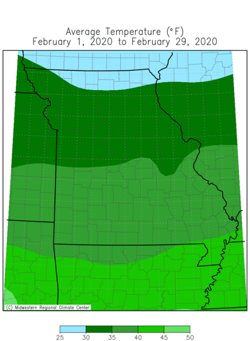
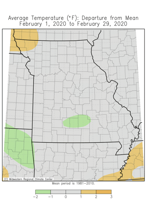
February temperatures were nearly two degrees above average in Missouri with preliminary data indicating a statewide average of 35.4℉, Figure 1. Warmest weather occurred during the first week of the month, Figure 2. Record high temperatures were established at several locations on Feb 2-3 when the mercury climbed into the 60's and 70's including Feb 2 records at St. Louis (70℉), Rolla (72℉), West Plains (75℉) and Springfield (76℉). Columbia broke a record high on Feb 3 with a high temperature of 72℉. Much colder weather occurred the following week with sub-zero temperatures reported across the northern half of Missouri on Feb 14. An arctic air mass with fresh snowpack, clear skies and light wind resulted in some very cold temperatures on Valentine's Day morning, Table 1.
Overall, it was a mild winter for the Show Me State with Dec-Jan-Feb recording above normal temperatures, Figure 3. Preliminary data indicate it was the 11th warmest winter on record, and followed the trend of mild winters over the past few decades, Figure 4.
| February 2020 Minimum Temperature Extremes* | |||
| Station Name* | County |
Min Temp (℉) | Date |
| Princeton | Mercer | -11 | 2/14 |
| Atlanta | Macon | -11 | 2/14 |
| Novelty | Knox | -11 | 2/14 |
| Shelbina | Shelby | -11 | 2/15 |
| Smithville Lake | Clay | -10 | 2/14 |
| Unionville | Putnam | -10 | 2/14 |
| Memphis | Scotland | -10 | 2/15 |
| *Reports are from the NWS Cooperative Network and Missouri Mesonet | |||
| Table 1. | |||
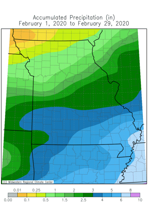
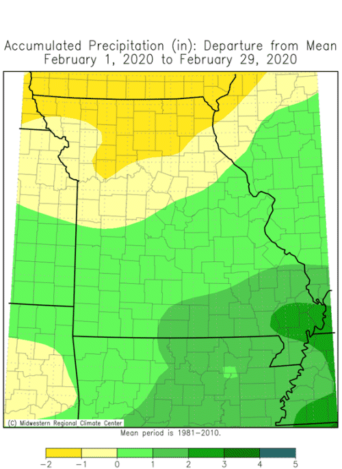
Seasonably wet weather continued into February, especially across the southern half of the state. Drier conditions occurred over northern sections. Preliminary data indicated a statewide average monthly total of 2.48 inches, or 0.43 inches above the long-term average. It was the third consecutive February with wetter than average conditions, Figure 5, and third consecutive wet winter in Missouri, Figure 6. Unusually wet conditions have prevailed since the beginning of 2019 with 10 out 14 months recording above average precipitation, Figure 7. The wet and mild winter weather translated to muddier than usual conditions for the state since frozen ground was the exception to the rule during the season.
A couple snow events occurred during the first half of February, impacting portions of Missouri. The heaviest monthly totals occurred over central and northeastern sections where 4-9 inches were common, Figure 8.
Wet conditions persisted across the Missouri and Mississippi River basins with elevated river levels and moist soil profiles increasing the threat for significant flooding across the region this spring, Figure 9.
With spring around the corner, farmers and gardeners are likely thinking about planting. University of Missouri Extension, in collaboration with MU Integrated Pest Management, developed a Missouri Frost Freeze Probabilities Guide. Median dates for the last hard freeze in Missouri (≤24°F) range from March 4 (extreme southeast Missouri) to April 3 (MO/IA border), Figure 10.
Jump to:
- Figure 1
- Figure 2
- Figure 3
- Figure 4
- Figure 5
- Figure 6
- Figure 7
- Figure 8
- Figure 9
- Figure 10
- Figure 11
- Figure 12
- Figure 13
- Figure 14
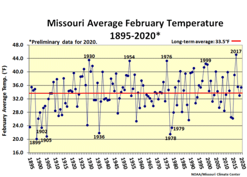
Figure 1.
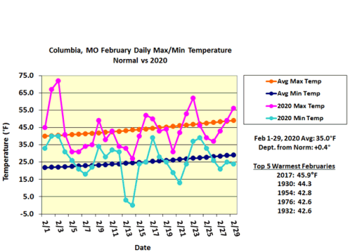
Figure 2.
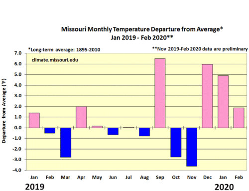
Figure 3.
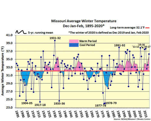
Figure 4.
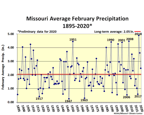
Figure 5.
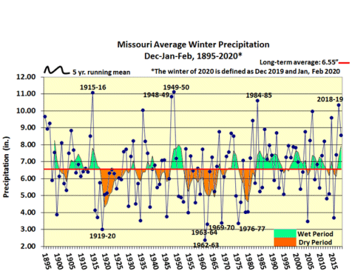
Figure 6.
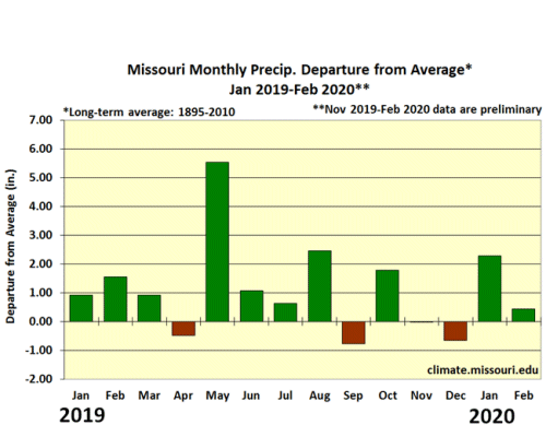
Figure 7.
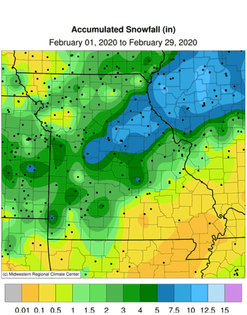
Figure 8.
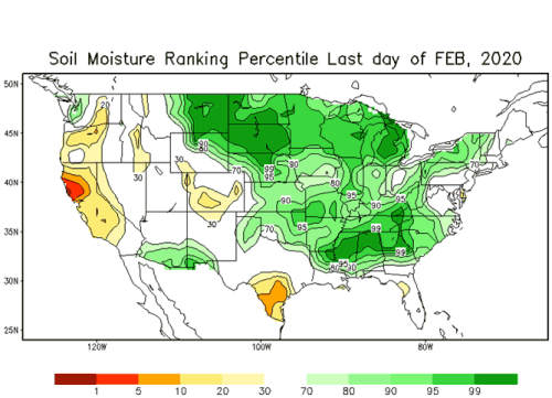
Figure 9.
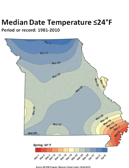
Figure 10.
Source: Pat Guinan, 573-882-5908