
April 2017 Weather and Its Impacts on Missouri
Pat Guinan
State Climatologist
Commercial Agriculture/University of Missouri Extension
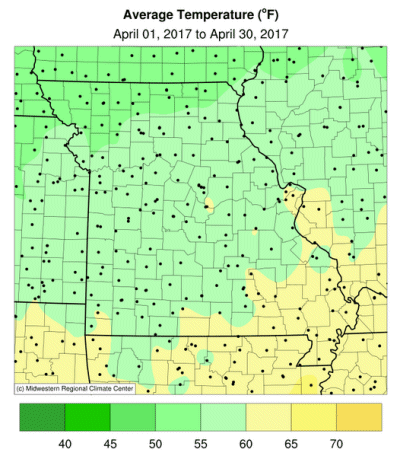
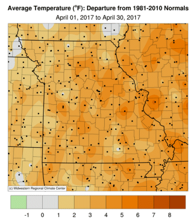
Daily temperatures were mostly above average across the Show Me State during April, especially during the 2nd and 3rd week of the month, Figure 1. The weather conditions have been representative of a warmer than average trend since autumn 2015, Figure 2. Preliminary April data indicate a statewide average temperature of 58.7 °F, slightly less than 4 degrees above the long-term average. There have been only four cooler than average Aprils in Missouri since 2001, Figure 3. Coldest temperatures occurred on the morning of April 7, when the mercury dipped to the upper 20s and lower 30s over parts of Missouri, however, several locations around the state reported no freezing weather for the month.
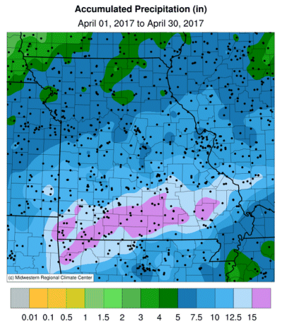
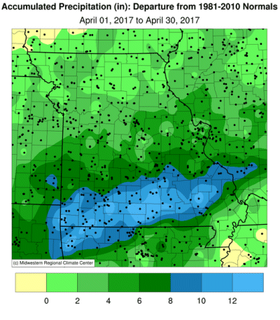
Exceptionally wet conditions, with record rainfall and historic flooding, occurred in April, Figure 4. Preliminary data indicate the statewide average precipitation total was 9.86 inches, eclipsing the previous record established in April 1994, Figure 5. The monthly total was 5.89 inches above average, nearly 2.5 times the normal. The extreme springtime wetness abruptly ended an extended period of dry weather that had emerged last fall and winter, Figure 6. Any concern for initial growing season drought was eliminated, with improving conditions denoted by Drought Monitor maps from March 28 and May 2, Figure 7.
A historic rain and flood event impacted the southern half of Missouri during the last weekend of April when many areas received 4-10 inches of rain on April 29-30, Figure 8. The governor declared a state of emergency on April 29. A slow moving storm system brought a prolonged period of moderate to heavy rain over the region resulting in flash flooding, road closures, dozens of water rescues, evacuations and flooding of homes, churches and businesses. At least 4 drownings were officially reported, all associated with vehicles and low water crossings. Rain gauges and radar estimates indicate several counties in far southern Missouri reported 8-10 inches during the 2-day period. A CoCoRaHS observer from Houston, MO, in Texas county, reported a 2-day total of 12.64 in her rain gauge.
Numerous rivers and streams overflowed their banks with thousands of bottomland acres inundated. A record crest occurred along the Current River when it reached 33.13 feet at Doniphan, and broke the previous record of 26.8 feet set in 1904. A record was also broken along the Current River at Van Buren. The Jacks Fork River at Eminence also crested at record height. Flood records were broken along the Meramec River at Steelville, Sullivan, and Eureka. Record crests were reported along the Gasconade at Hazelgreen, Rich Fountain and Jerome. The Big River set a record flood crest near Richwoods.
The mild and drier conditions earlier in the month provided farmers with planting opportunities. Heavy rainfall and flooding toward the end of the month halted planting and raised concerns for flooded cropland. According to the National Agricultural Statistics Service, corn planting was 67% complete by the end of the month, 11 percentage points ahead of the 5-year average. Stock water supplies were reported mostly adequate (65%), as well as hay supplies and other roughages (83%) according to the Missouri Agricultural Statistics Service. Nearly two-thirds of the pastures were in good condition. Topsoil and subsoil moisture supplies were mostly adequate to surplus statewide.
Jump to:
- Figure 1
- Figure 2
- Figure 3
- Figure 4
- Figure 5
- Figure 6
- Figure 7
- Figure 8
- Figure 9
- Figure 10
- Figure 11
- Figure 12
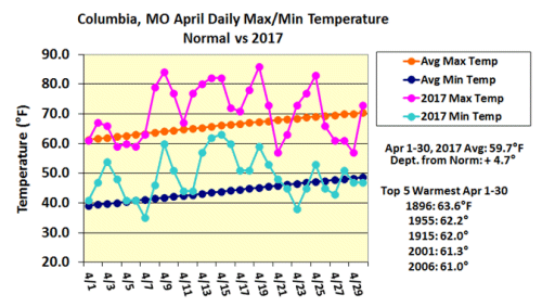
Figure 1.
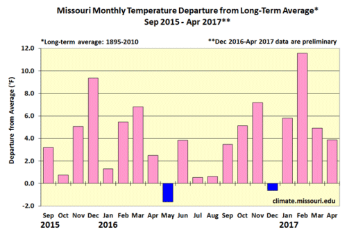
Figure 2.
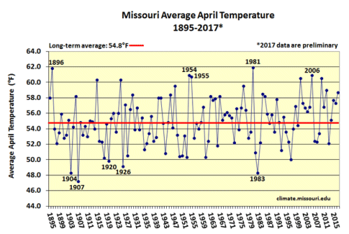
Figure 3.
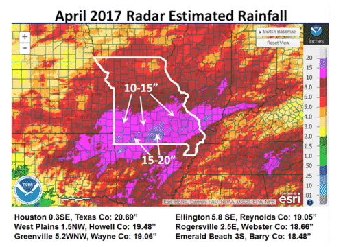
Figure 4.
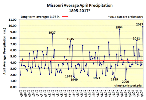
Figure 5.
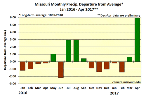
Figure 6.
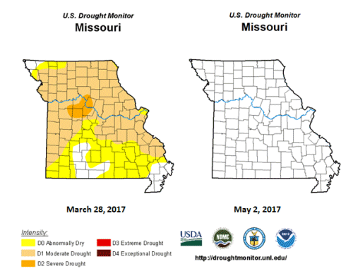
Figure 7.
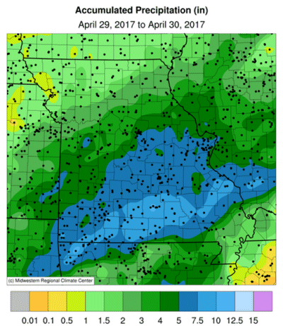
Figure 8.
Source: Pat Guinan, 573-882-5908