
April 2018 Weather and Its Impacts on Missouri
Pat Guinan
State Climatologist
Commercial Agriculture/University of Missouri Extension
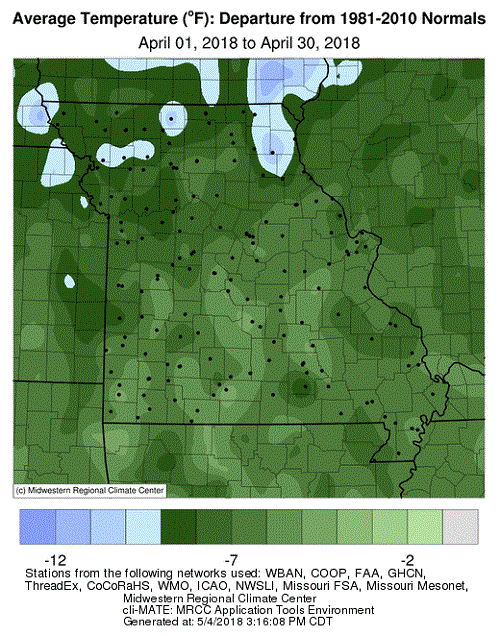
A highly unusual and persistent upper air weather pattern brought unseasonably cold temperatures to much of the north central U.S. during the first 3 weeks of April. A pool of cold air spinning over Hudson Bay pumped reinforcing shots of arctic air into the region, leading to record temperatures and several snow events for the month. Temperature departures averaged more than 10 degrees below normal for the 3-week period, Figure 1. Despite seasonable temperatures during the last week of April, many communities in the region still reported their coldest April on record, Figure 2. Official statewide data are pending, but some states will likely document their coldest April on record, including Wisconsin and Iowa, where statewide departures were more than 9 degrees below normal by the end of April, Figure 3.
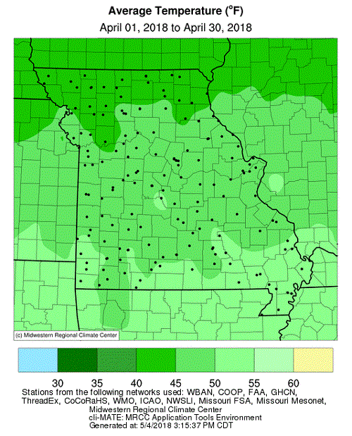
Preliminary data for Missouri indicate the statewide average temperature for April was 48.0°F, or 6.8 degrees below the long-term average. The month ranked as Missouri's 2nd coldest April on record, only April 1907 was colder, Figure 4. In recent history, 1983 was comparable, and the cold conditions were counter to the trend of warm Aprils that have prevailed for the past couple decades. It was the largest cold monthly temperature departure in more than 3 years for Missouri, when February 2015 averaged 7.4 degrees below normal, Figure 5.
The intense cold weather during the first half of April broke records in regard to consecutive days with freezing temperatures. Several communities across the Missouri reported 10 or more consecutive days with minimum temperatures ≤32°F, Figure 6, an unprecedented occurrence for April. Single digit April minimum temperature records were also established in some northern communities early in the month, Table 1, and came within a few degrees of breaking the all-time low April temperature record for Missouri that occurred at the St. Joseph Airport on April 3, 1975, when the mercury dipped to 2°F.
| April 2018 Missouri Lowest Minimum Temperature | |||
| Location | County | Min Temp (°F) | Date |
| Albany* | Gentry | 5 | 2 |
| Spickard 7W | Grundy | 5 | 2 |
| Green City 5N b | Sullivan | 6 | 2 |
| Memphis | Scotland | 6 | 3 |
| Novelty* | Knox | 6 | 2 |
| *Missouri Mesonet weather station | |||
| Table 1. | |||
The cold weather delayed spring vegetative growth, and spring blooming was running 2-3 weeks behind normal across Missouri according to the National Phenology Network, Figure 7.
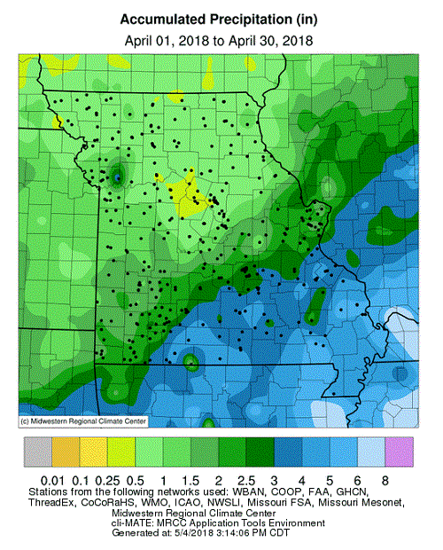
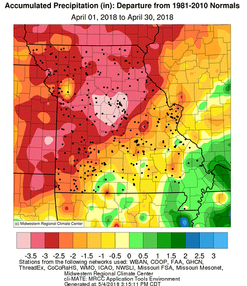
Most locations in Missouri experienced drier than average conditions during April. Preliminary data indicate a statewide precipitation total of 2.20 inches, or 1.77 inches below the long-term average. It was the driest April since 2000, Figure 8, and the first below average month since January, Figure 9.
According to radar estimates, Figure 10, monthly precipitation totals were heaviest across south central and southeastern sections where 3-5 inches were common. Many southwestern counties reported 2-3 inches, while lighter amounts, ranging from 1-2 inches, were typical across west central, east central and northwestern Missouri. Portions of central and much of north central and northeastern Missouri reported less than 1-inch, with a few areas in the region receiving less than 0.5 inches for the month. The Columbia Regional Airport reported 0.45 inches, which is the driest April in 129 years of record. According to the U.S. Drought Monitor map for May 1, 2018, the northwestern quarter of Missouri was experiencing abnormally dry to moderate drought conditions, Figure 11.
The extended period of cold weather provided opportunities for snow events to impact the state. The heaviest and most widespread event occurred on the first of the month when 1-6 inches fell over the northern half of Missouri. Heaviest amounts were reported along a line extending from St. Joseph, MO to Quincy, IL, where 3-6 inches were common, Figure 12. Steffenville, located in far northeastern Missouri, reported 6.6 inches of snow. Two lighter snow events occurred on the 8th and 15th of the month.
National Weather Service (NWS) storm surveys indicated 2 tornadoes occurred in the Missouri Bootheel during the evening of April 3. The strongest tornado, with estimated peak winds at 110 mph (EF-1 intensity) occurred just northwest of Matthews, in Stoddard County. The other tornado, with EF-0 intensity, touched down in New Madrid County, just southeast of Baker. Tree and property damage were reported with both storms, but no injuries. Another NWS survey indicated four tornadoes touched down in southwestern Missouri during the evening of April 13th. Two tornadoes were reported in Wright County and two in Texas County. The strongest tornado, with peak winds estimated at 130 mph (EF-2 intensity), developed near Macomb, in Wright County. One residence was destroyed, but no injuries reported.
The cold weather initially delayed fieldwork activity and planting opportunities statewide, with wetter conditions in the Bootheel also slowing progress, but drier, warmer weather during the last week of April, let to more favorable conditions. According to the Missouri Agricultural Statistics Service April 29th report, corn planting was 52% complete by the end of the month, one percentage point ahead of the 5-year average. However, only 6% of the corn had emerged, compared to the 5-year average of 22%.
Stock water supplies were reported mostly adequate (88%), but 63% of the hay supplies and other roughages were considered in short to very short supply. Autumn drought last year limited pasture growth and many producers were forced to feed hay early. The cold spring weather also hindered grass growth and supplies continued to be depleted. The majority of pastures, 53%, were reported in fair condition with 23% poor. Despite drier April weather, topsoil and subsoil moisture supplies were still mostly adequate statewide.
Jump to:
- Figure 1
- Figure 2
- Figure 3
- Figure 4
- Figure 5
- Figure 6
- Figure 7
- Figure 8
- Figure 9
- Figure 10
- Figure 11
- Figure 12
- Figure 13
- Figure 14
- Figure 15
- Figure 16
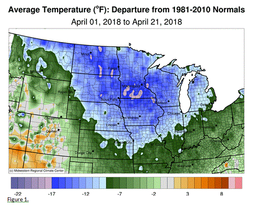
Figure 1.
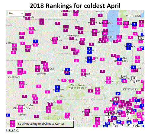
Figure 2.
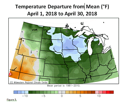
Figure 3.
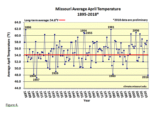
Figure 4.
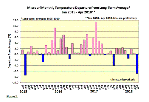
Figure 5.
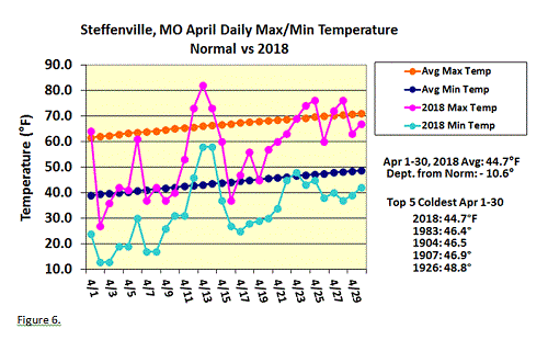
Figure 6.
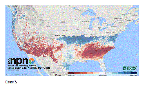
Figure 7.
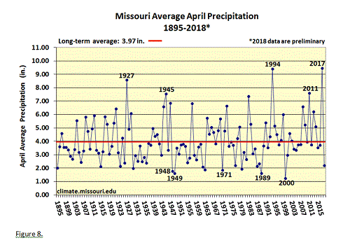
Figure 8.
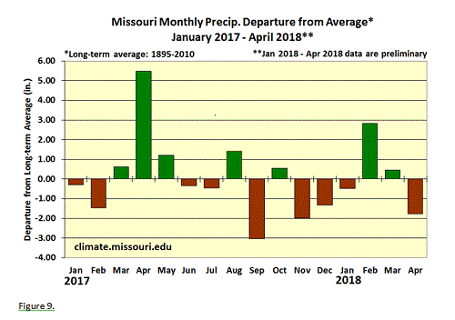
Figure 9.
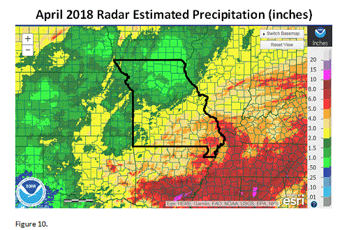
Figure 10.
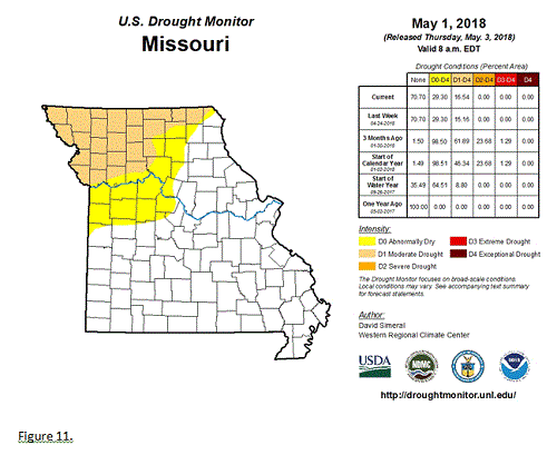
Figure 11.
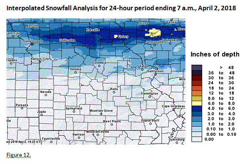
Figure 12.
Source: Pat Guinan, 573-882-5908