
April 2023 Weather and Its Impacts on Missouri
Dr. Pat Guinan
Climatologist
Extension Associate Professor Emeritus
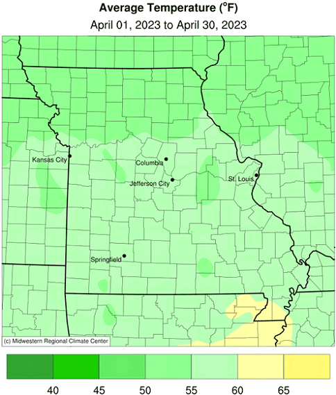
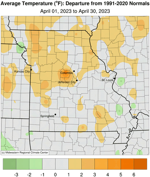
Above average temperatures generally impacted Missouri during the first three weeks of April, Figure 1. Cooler, more seasonable weather rounded out the last ten days of the month. It was the first warmer than average April in four years, Figure 2. Preliminary April data indicate a statewide average temperature of 56.2 °F, 1.7 degrees above the long-term average. Every month this year has been warmer than average, Figure 3. There were exceptions, but most official observers experienced freezing temperatures during the month. Several locations reported their coldest temperatures late in the month, between Apr 23-24, Table 1.
| Some Missouri locations where minimum temperature occurred between April 23-24, 2023* | |||
| Location | County | Minimum Temp. (°F) | Date |
| Kirksville | Adair | 22° | 23 |
| Salem 10W | Dent | 23° | 23 |
| Smithville Lake | Clay | 24° | 23 |
| Shelbina | Shelby | 24° | 23 |
| Rolla-Vichy AP | Maries | 24° | 23 |
| Rosebud | Gasconade | 25° | 24 |
| Cole Camp 3NW | Benton | 25° | 23 |
| Winona 3SW | Shannon | 25° | 24 |
| Sweet Springs | Saline | 26° | 24 |
| Sedalia Water Plant | Pettis | 26° | 23 |
| Buffalo2N | Dallas | 26° | 23 |
| Round Spring 2SW | Shannon | 26° | 24 |
| Kearney 3E | Clay | 27° | 23 |
| Monroe City | Monroe | 27° | 24 |
| Chesterfield AP | St. Louis | 27° | 24 |
| Clinton | Henry | 27° | 24 |
| Billings 1SW | Christian | 27° | 23 |
| Licking 4N | Texas | 27° | 23 |
| Waynesfield 2W | Pulaski | 27° | 23 |
| *NWS Cooperative Weather Station | |||
| Table 1. | |||
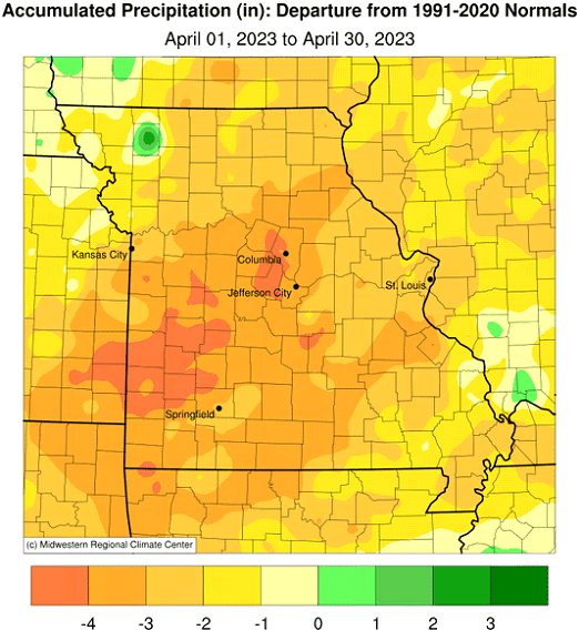
Many areas in Missouri experienced drier than average conditions during April. Preliminary data indicate a statewide precipitation total of 1.71 inches, 2.26 inches below the long-term average. It was the driest April since 2000, and 4th driest April on record, Figure 4. It was also the first drier than average month for the year, Figure 5.
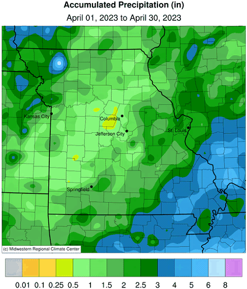
According to radar estimates, Figure 6, April precipitation totals were heaviest across far southeastern sections where 3-5 inches were common. Totals across much of northwestern, east central and south-central Missouri were between 1.5-3 inches, and lighter amounts, ranging from 0.5-1.5 inches, were common over southwestern, west central, central, north central and northeastern Missouri.
Dryness intensified across parts of Missouri in April. According to the U.S. Drought Monitor, a 50-mile-wide corridor of moderate drought stretched from southwest to northeast Missouri, centered on a line from Nevada to Columbia to south of Hannibal, Figure 7.
According to the Missouri Agricultural Statistics Service, for the week ending April 30, corn planting was 80% complete, 39 percentage points ahead of the 5-year average. Stock water supplies were reported mostly adequate at 91%, but 53% of the hay supplies and other roughages were in short to very short supply. About half of the pastures were in fair condition. Topsoil and subsoil moisture supplies were mostly adequate at 57% and 64%, respectively, but a sizeable percentage of topsoil was in short (36%) to very short (5%) condition with subsoil at 30% short and 4% very short.
Jump to:
- Figure 1
- Figure 2
- Figure 3
- Figure 4
- Figure 5
- Figure 6
- Figure 7
- Figure 8
- Figure 9
- Figure 10
- Figure 11
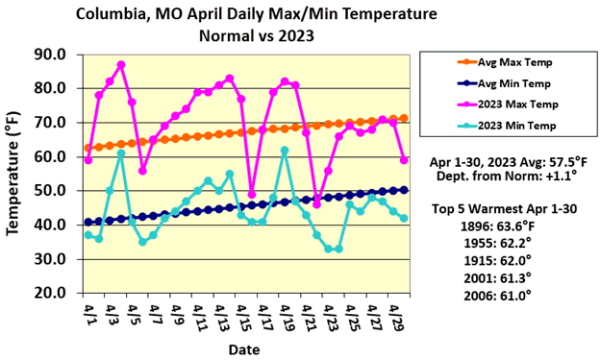
Figure 1.
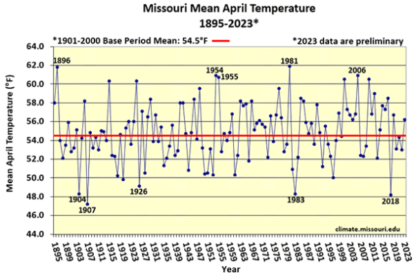
Figure 2.
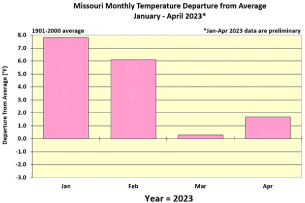
Figure 3.
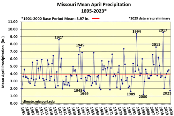
Figure 4.
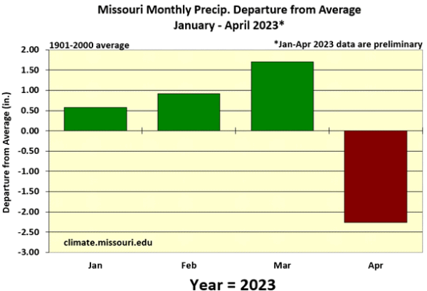
Figure 5.
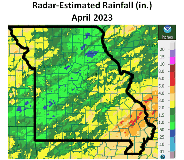
Figure 6.
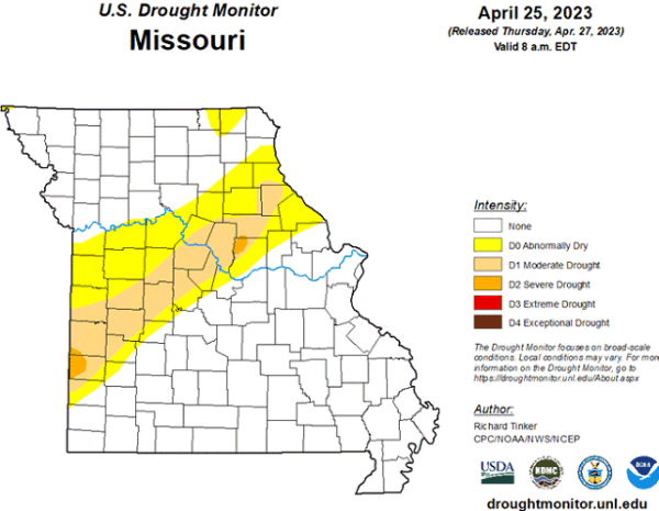
Figure 7.
Source: Dr. Pat Guinan, 573-882-5908