November 2010 Weather and Its Impacts on Missouri
Pat Guinan
State Climatologist
Commercial Agriculture/University of Missouri Extension
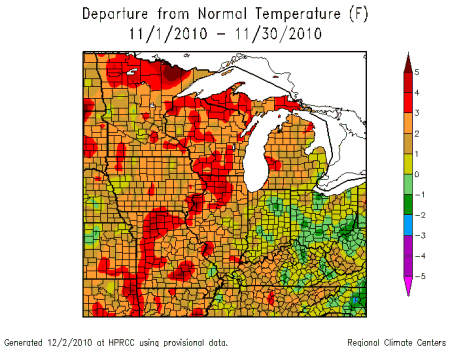
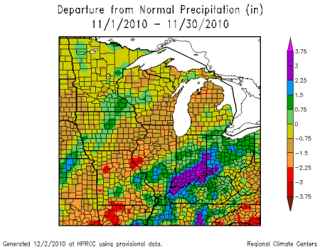
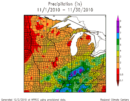
A progressive weather pattern affected Missouri during most of November with variable weather conditions and numerous frontal systems sweeping through the state. Overall, preliminary data were indicating monthly temperatures averaging 2-3 degrees above normal with near normal precipitation, averaging slightly less than 3 inches for the state.
Regionally, precipitation averaged below normal across much of northern and central sections, as well as portions of far southern Missouri. A few locations across northern Missouri reported less than 1-inch for the month. A corridor of above normal rainfall was located along I-44, from Springfield to St. Louis, and southward from St. Louis to parts of southeastern Missouri.
Some of the lowest monthly precipitation totals were found over parts of north central and northeastern Missouri where 0.83 inches was reported near Brookfield in Linn County, and New London, in Ralls County, reported just over 0.50 inches. Highest amounts, in excess of 5 inches, were found along the I-44 corridor from Springfield to St. Louis and in the Missouri Bootheel. A weather observer near Marshfield, in Webster County, reported 7.16 inches for the month.
There were two severe weather events during the month with the first one occurring on the 22nd when quarter to golf ball sized was reported in a few southwestern and east central Missouri counties. A second more notable storm event occurred the day before Thanksgiving, on November 24th.
Severe thunderstorms developed in southwestern sections during the late afternoon and evening on November 24 and spawned 3 tornadoes. A storm survey team from the National Weather Service office in Springfield documented two tornadoes in Hickory County near the communities of Wheatland and Cross Timbers, and one tornado in Polk County near Brighton, MO. The Cross Timbers and Brighton tornadoes were categorized as EF1 tornadoes with winds estimated near 100 mph. The tornado near Wheatland was classified as EF0 with winds approaching 80 mph. The tornadoes resulted in some tree and property damage but no injuries were reported.
The dry and sunny conditions experienced in October spilled into the first week of November and resulted in continued excellent harvesting opportunities for farmers. According to the Missouri Agricultural Statistics Service, harvest was running 4 weeks ahead of normal with 98% of the corn and 97% of the soybean harvest completed by November 7th. Planting of winter wheat was also running well ahead of schedule with 97% complete, however, there were concerns for winter wheat germination due to persistent dry conditions over parts of the state. Some replanting was reported.
According to the National Drought Mitigation Center's Drought Monitor map, severe to extreme drought continued to plague parts of southeastern Missouri, especially in the Bootheel region, where significant year end deficits had accumulated. These dry conditions, however, were tempered somewhat when significant rain events occurred toward the end of the month in the area.
As we approach the winter season (December, January, and February), the latest winter outlook from the Climate Prediction Center is calling for above normal temperatures over all of Missouri. Additionally, the outlook calls for above normal precipitation for the southeastern half of the state with the highest likelihood of this occurring over the Bootheel region. Equal chances of above, below, and near normal precipitation are indicated for the rest of the state. Normal precipitation for the winter months in Missouri varies from just under 3 inches in the northwest corner to nearly a foot in the Bootheel.