
October 2019 Weather and Its Impacts on Missouri
Pat Guinan
State Climatologist
University of Missouri Extension
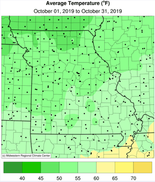
The summerlike September weather spilled into the beginning of October when high temperatures climbed into the 80�s and 90s, but hot weather was short-lived by a changing weather pattern and cooler conditions the rest of the month, Figure 1. High temperatures topped out in the 30�s toward the end of the October and an unusual snow event brought more trick and less treat for many on Halloween morning, Figure 2.
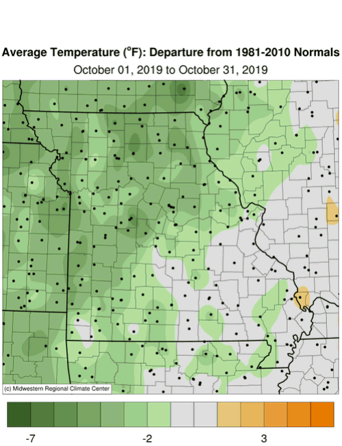
Preliminary data indicate the statewide average October temperature was 53.7�F, or 3.3� below the long-term average. It was the coldest October in a decade, Figure 3, and the fifth below average month for the year, Figure 4. Coldest departures from normal occurred across the northwestern half of the state, averaging 3-5� below normal. The southeastern half of Missouri ranged from near average, especially in far southeastern sections, to three degrees below average.
Strong temperature contrasts have been a recurring theme in 2019 between the north central U.S., where colder than average conditions have been the rule, compared to the southeastern U.S., where above average temperatures have dominated, Figure 5. These contrasting conditions have been most notable in February, May and October this year, Figure 6.
The first fall freeze impacted much of the state, with the exception of far southeastern sections, when temperatures dipped into the upper 20�s to lower 30�s during the morning of October 12. The freezing weather was near to a few days earlier than the median date for northern Missouri and eastern Ozarks and 7-10 days earlier than average for central Missouri and western Ozarks. All locations reported freezing weather by the end of the month.
The beginning of October was dry in portions of south central and southeastern Missouri and for the first time this year a drought status category was depicted in some southeastern border counties according to the October 1 Drought Monitor map. Wetter conditions emerged statewide as the month progressed and Missouri was �drought-free� by the end of October, Figure 7.
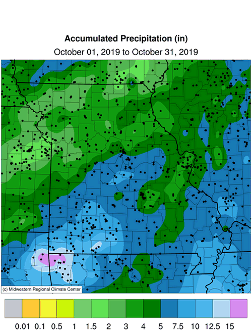
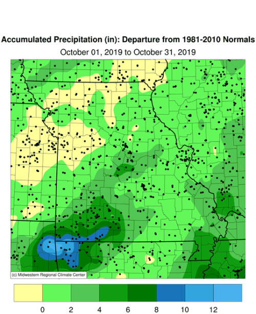
Preliminary data indicate the statewide average precipitation total was 5.30 inches, or 2.09 inches above the long-term average. It was the wettest October since 2014, Figure 8, and the eighth wetter than average month for the year, Figure 9. It was the fourth wettest Jan-Oct on record for the Show Me State and wettest Jan-Oct since 2008, Figure 10.
Heaviest precipitation occurred over the southeastern 2/3 of the state where 4-7 inches were common, Figure 11. A few southwestern border counties reported more than a foot of rain including locations in Barry, Stone and Taney Counties. A CoCoRaHS observer just south of Forsyth, MO, in Taney County, reported 15.54 inches for the month.
Soil moisture conditions were unusually wet at the end of October across much of the north central and central U.S., Figure 12. As we transition into the cold season, the antecedent wet conditions will likely persist through winter into early spring, and an elevated risk for flooding over the next several months will likely persist across the Missouri and Mississippi River Basins.
Snow in Missouri during October is unusual, but it does occur. An event last year impacted portions of northwest Missouri on the 15th where amounts ranged from a trace to 1.5 inches. This year, a snow event impacted the northern half of the state on Halloween morning with many locations reporting a trace to more than four inches, Figure 12 and Table 1.
| October 31, 2019 Snow Event | ||
| Location | County |
Snowfall (in.) |
| Unionville | Putnam | 4.2 |
| Memphis 0.1S | Scotland | 3.0 |
| Higginsville | Lafayette | 3.0 |
| Edina | Knox | 2.9 |
| Green City 5N | Sullivan | 2.6 |
| Lancaster 0.2SE | Schuyler | 2.5 |
| Brookfield 3.7NNE | Linn | 2.5 |
| Jamesport 1.3ESE | Daviess | 2.5 |
| Stanberry 4.4NNE | Gentry | 2.5 |
| Clifton Hill 1.2SSE | Randolph | 2.5 |
| Macon 4.6NE | Macon | 2.5 |
| Source: NWS Coop and CoCoRaHS Observations | ||
| Table 1. | ||
Earliest measureable snowfall dates for locations with extensive snowfall records (>100 years) are listed in Table 2. Measureable snowfall is defined as ≥0.1 inches.
| Missouri Earliest Measureable Snowfall | ||
| Location | Date |
Snowfall (in.) |
| Springfield | Oct 17, 1898 | 1.0 |
| Kansas City | Oct 17, 1898 | 3.3 |
| Columbia | Oct 23, 1917 | 0.2 |
| St. Louis | Oct 20, 1916 | 0.1 |
| Source: NOAA/NCEI/NWS | ||
| Table 2. | ||
October has the distinction of being the earliest month in Missouri to witness snowstorms. One of note in recent history was a major snow event on October 22-23, 1996 when portions of northwestern and west central Missouri reported 3-11.5 inches of snow. Heavy wet snow fell on trees that were in leaf leading to numerous downed branches and power lines.
The 1-day state snowfall record for October occurred at two locations on different dates. Rolla, Phelps County, reported 11.5 inches on October 27, 1913 and Fairfax, Atchison County, reported 11.5 inches on October 23, 1996.
The wet, cool weather during the month limited opportunities for crop dry-down and harvest. According to the Missouri Agricultural Statistics Service, for the week ending October 27, corn and soybean harvest was 64% and 43% complete, respectively; 20 percentage points behind the 5-year average for corn and 15 percentage points behind for soybean. The majority of topsoil and subsoil moisture conditions were reported adequate at 86% and 85%, respectively. Pasture conditions were mostly good at 65% with 10% reported excellent. Hay supplies were mostly adequate (71%) to excellent (8%) with only 20% reported short to 1% very short. Stock water supplies were mostly adequate (93%).
Jump to:
- Figure 1
- Figure 2
- Figure 3
- Figure 4
- Figure 5
- Figure 6
- Figure 7
- Figure 8
- Figure 9
- Figure 10
- Figure 11
- Figure 12
- Figure 13
- Figure 14
- Figure 15
- Figure 16
- Figure 17
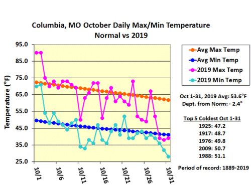
Figure 1.
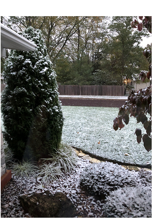
Figure 2. Columbia, MO morning snowfall, October 31, 2019
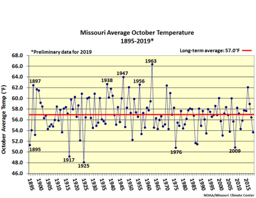
Figure 3.
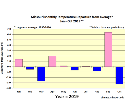
Figure 4.
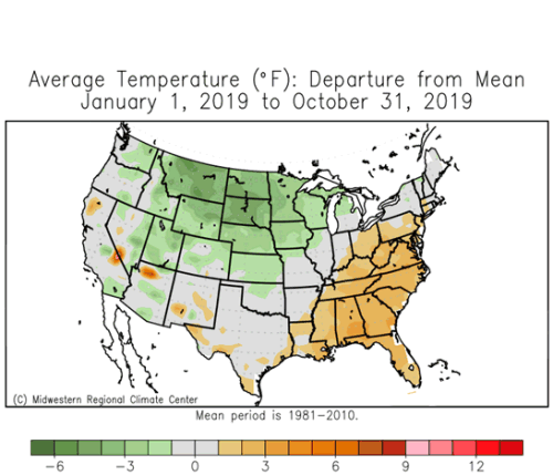
Figure 5.
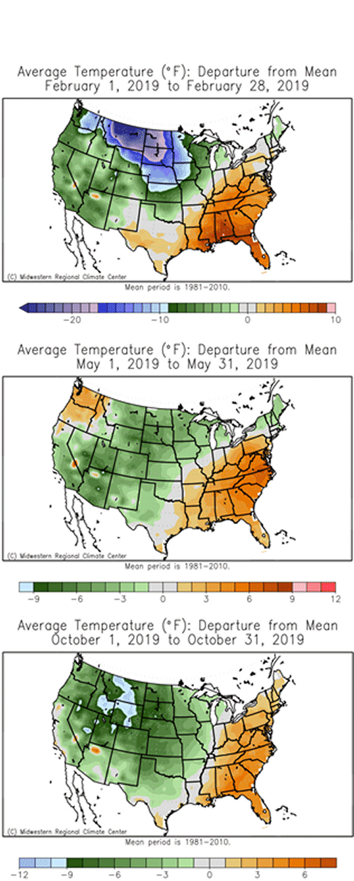
Figure 6.
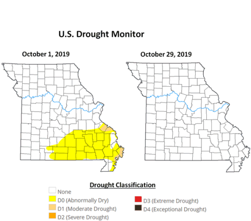
Figure 7.
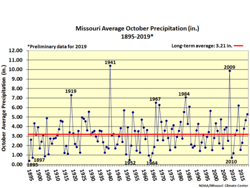
Figure 8.
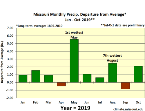
Figure 9.
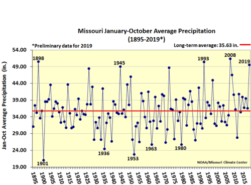
Figure 10.
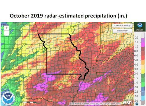
Figure 11.
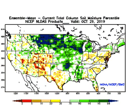
Figure 12.

Figure 13.
Source: Pat Guinan, 573-882-5908