
September 2017 Weather and Its Impacts on Missouri
Pat Guinan
State Climatologist
Commercial Agriculture/University of Missouri Extension
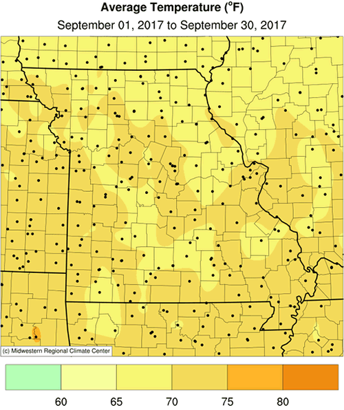
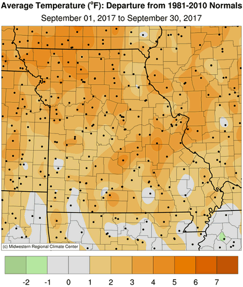
Above normal temperatures dominated the Show Me State during September, especially after the first week of the month when a ridge of high pressure parked over the western U.S. shifted eastward into the middle part of the country. An early autumn heat wave brought the warmest weather for the month, with many locations reporting several days of high temperatures in the 90's, Figure 1. Preliminary data indicate a statewide average monthly temperature of 70.2°F, nearly two degrees above the long-term average, Figure 2. Warmer than normal monthly temperatures have prevailed in 2017, with only 2 months averaging cooler than normal, Figure 3.
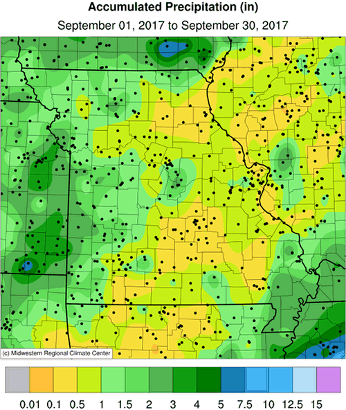
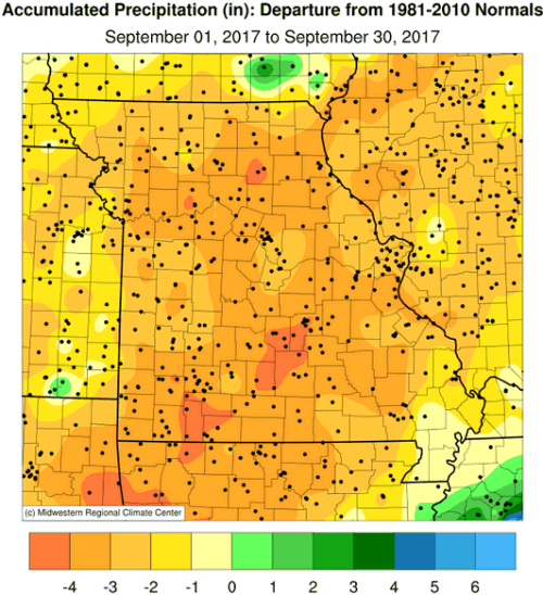
Rain events were few, light and sporadic during the month with preliminary data indicating a statewide average of 1.10 inches, nearly 3-inches below the long-term average, Figure 4. It was the 5th driest September on record for Missouri, Figure 5.
Driest conditions were found over northeastern sections and in a corridor extending from southwest of St. Louis to Branson. According to radar estimates, many locations in these areas received less than 0.50" during September, Figure 6. CoCoRaHS observers in several counties reported less than 0.25" for the month and observers in Clark, Jefferson, Crawford and Taney Counties reporting no measureable rainfall. Remnants of Hurricane Irma brushed southeastern Missouri with scattered light showers on Sep 12-13. Heaviest rainfall from the system ranged from 0.25" to .75", and was confined to the Bootheel.
According to the Drought Monitor map, abnormally dry to moderate drought conditions covered nearly two-thirds of the state by the last week of September, Figure 7.
University of Missouri turf scientist, Dr. Lee Miller, provided the following impact statements due to the extended dryness:
"All non-irrigated turfgrass areas are showing symptoms of drought dormancy. The lack of precipitation has severely hampered seeding efforts for cool season turfgrasses. Late August - early October is the prime time for seeding tall fescue and Kentucky bluegrass on lawns, sports fields, and sod farms. Without consistent, supplemental irrigation, seed may germinate but not establish due to insufficient water. Weeds such as lespedeza have been greatly encouraged by the current drought situation."
According to the Missouri Agricultural Statistics Service, as of October 1, 67% of the corn and 66% of the soybean crop was reported in good to excellent condition. The majority of hay and roughages were adequate (76%) to surplus (15%), while 81% of the stock water supplies were adequate. Corn harvest was advancing behind average at 44% compared to the 5-year average of 53%. Only 39% of the pastures were reported in good to excellent condition. More than half of the topsoil moisture conditions in the state were short (38%) to very short (21%). The majority of subsoil moisture conditions were also reported to be short (39%) to very short (15%).
Most sections of the Missouri will experience their first fall frost during October, Figure 8. Using climatology, the northern quarter of Missouri and eastern Ozarks will generally experience a light freeze (32° or cooler) by mid-October. Central Missouri and the western Ozarks will experience a light freeze by October 21st, and a few days later in urban areas. The Bootheel will have a light freeze typically toward the end of October or early November. For more information on frost/freeze probabilities for Missouri, including additional temperature thresholds, please visit the following link: http://ipm.missouri.edu/FrostFreezeGuide.
Jump to:
- Figure 1
- Figure 2
- Figure 3
- Figure 4
- Figure 5
- Figure 6
- Figure 7
- Figure 8
- Figure 9
- Figure 10
- Figure 11
- Figure 12
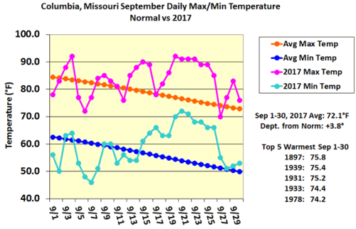
Figure 1.
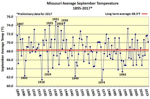
Figure 2.
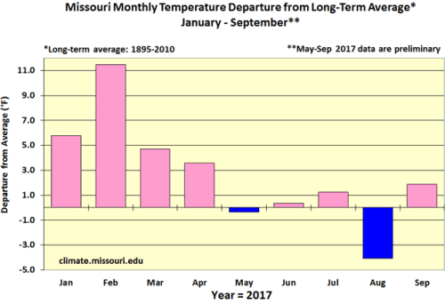
Figure 3.
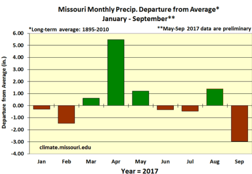
Figure 4.
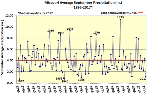
Figure 5.
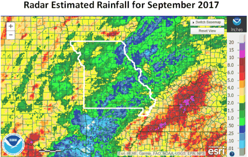
Figure 6. Radar Estimated Rainfall for September 2017
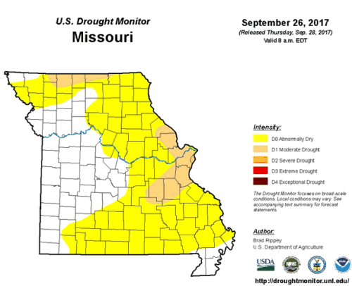
Figure 7.
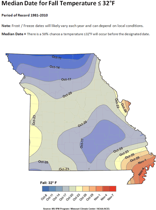
Figure 8. Median Date for First Fall Freeze
Source: Pat Guinan, 573-882-5908