
September 2018 Weather and Its Impacts on Missouri
Pat Guinan
State Climatologist
University of Missouri Extension
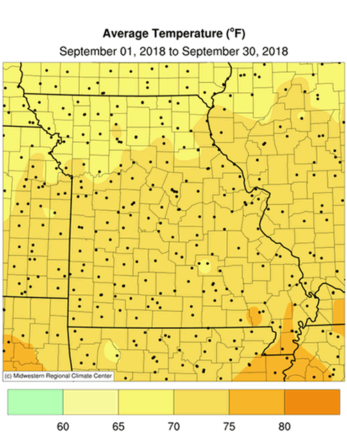
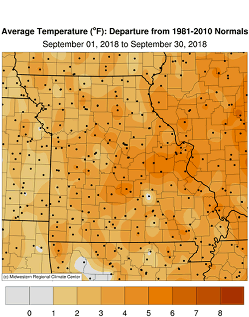
Above normal temperatures dominated the Show Me State during September, especially during the middle of the month when most locations reported daily high temperatures in the upper 80’s and lower 90’s from September 14-20, Figure 1. The majority of daily September minimum temperatures were also above normal. Preliminary data indicate a statewide average monthly temperature of 71.4°F, more than three degrees above the long-term average. It was the fourth consecutive September with above average temperatures, Figure 2. Only four months have been cooler than average since January 2017, Figure 3.
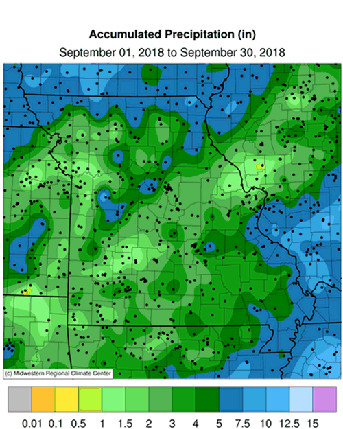
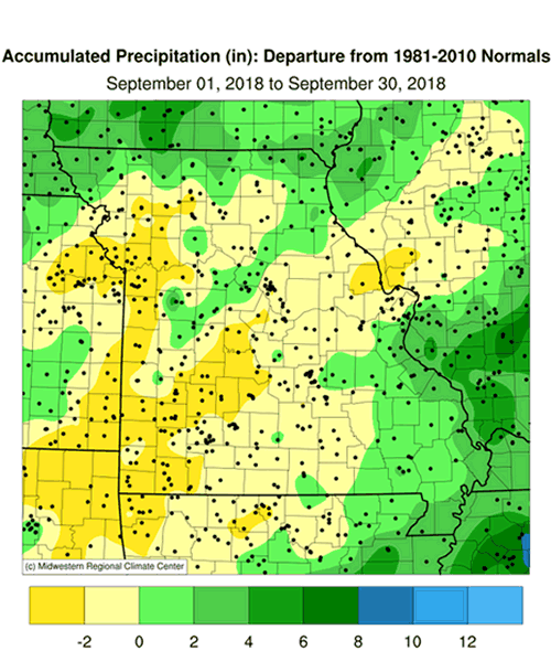
Precipitation was variable across Missouri with the majority of it falling during the first half of September. Remnants of Tropical Storm Gordon impacted the southeastern half of the state on Sep 7-8. The average statewide preliminary monthly total was 3.48 inches, or 0.6 inches below the long-term average. It was the second consecutive drier than average September for the state, Figure 4, and the 6th drier than average month for the year, Figure 5.
According to radar estimates and ground truth reports, lightest rainfall totals occurred over portions of west central, southwestern and east central Missouri and heaviest amounts were seen over several northern and southeastern border counties, Figure 6. A thin corridor of heavier rainfall extended from Henry County northeastward through portions of Benton, Pettis, Cooper, Howard, Randolph and Monroe Counties. Some of the lightest and heaviest rain gauge reports for September are listed in Table 1.
| MISSOURI | |||
| Station Name* | County |
Rainfall (in.) | |
| Lightest | Dunnegan 2.4NNW | Polk | 0.65 |
| Lexington | Lafayette | 0.82 | |
| Liberty 4.1NNW | Clay | 0.97 | |
| Pleasant Hill WFO | Cass | 0.99 | |
| Greenfield 2SE | Dade | 1.10 | |
| Heaviest | Luray 2N | Clark | 9.01 |
| Portageville (Delta Center) | Pemiscot | 8.37 | |
| Windsor 4.2SSE | Henry | 7.95 | |
| Oak Ridge 1.5WSW | Cape Girardeau | 7.85 | |
| Downing | Schuyler | 7.63 | |
| *Rain gauges are from the NWS Cooperative Network, CoCoRaHS Network, Missouri Mesonet | |||
| Table 1. | |||
The U.S. Drought Monitor map for the last week of September showed some improvement compared to drought conditions depicted at the end of August, Figure 7.
According to the Missouri Agricultural Statistics Service, as of September 30, 44% of the soybean crop was reported in good to excellent condition compared to 66% at the same time last year. The majority of hay and roughages were short (33%) to very short (43%) with 0% surplus, while 59% of the stock water supplies were adequate. Corn harvest was advancing ahead of average at 65% compared to the 5-year average of 42%. Only 27% of the pastures were reported in good (26%) to excellent (1%) condition, 38% were in poor (25%) to very poor (13%) condition. Just 40% of topsoil moisture conditions were short (29%) to very short (11%). The majority of subsoil moisture conditions were also reported to be short (30%) to very short (23%).
Most sections of the Missouri will experience their first fall frost during October, Figure 8. Using climatology, the northern quarter of Missouri and eastern Ozarks will generally experience a light freeze (32° or cooler) by mid-October. Central Missouri and the western Ozarks will experience a light freeze by October 21st, and a few days later in urban areas. The Bootheel will have a light freeze typically toward the end of October or early November. For more information on frost/freeze probabilities for Missouri, including additional temperature thresholds, please visit the following link: http://ipm.missouri.edu/FrostFreezeGuide.
Jump to:
- Figure 1
- Figure 2
- Figure 3
- Figure 4
- Figure 5
- Figure 6
- Figure 7
- Figure 8
- Figure 9
- Figure 10
- Figure 11
- Figure 12
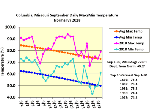
Figure 1.
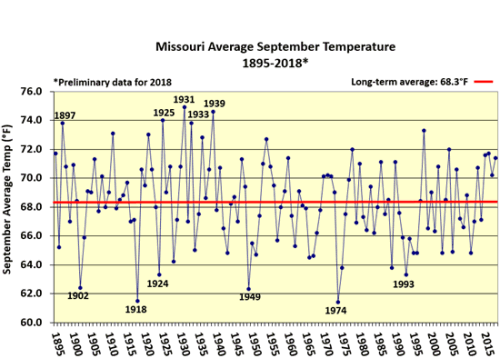
Figure 2.
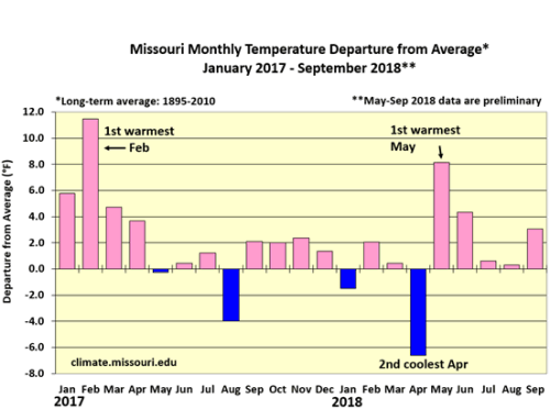
Figure 3.
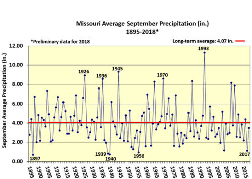
Figure 4.
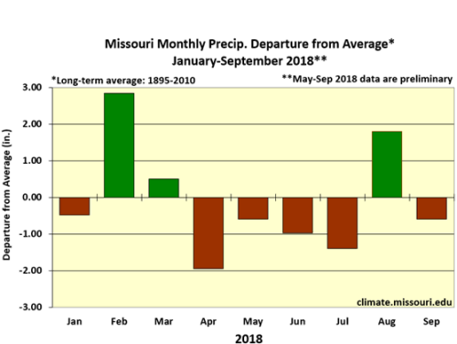
Figure 5.
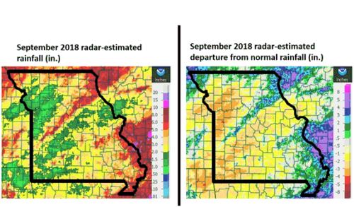
Figure 6.
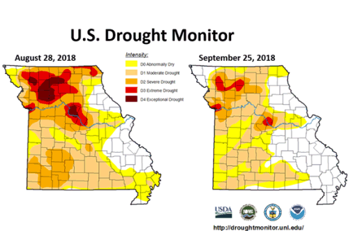
Figure 7.
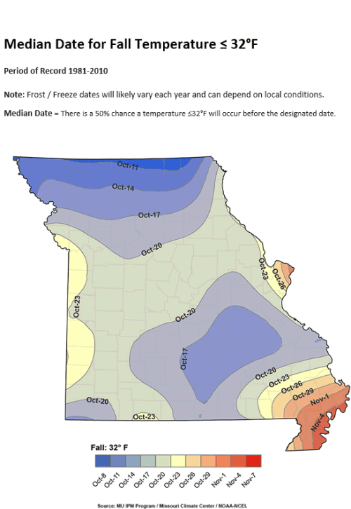
Figure 8.
Source: Pat Guinan, 573-882-5908