
September 2019 Weather and Its Impacts on Missouri
Pat Guinan
State Climatologist
University of Missouri Extension
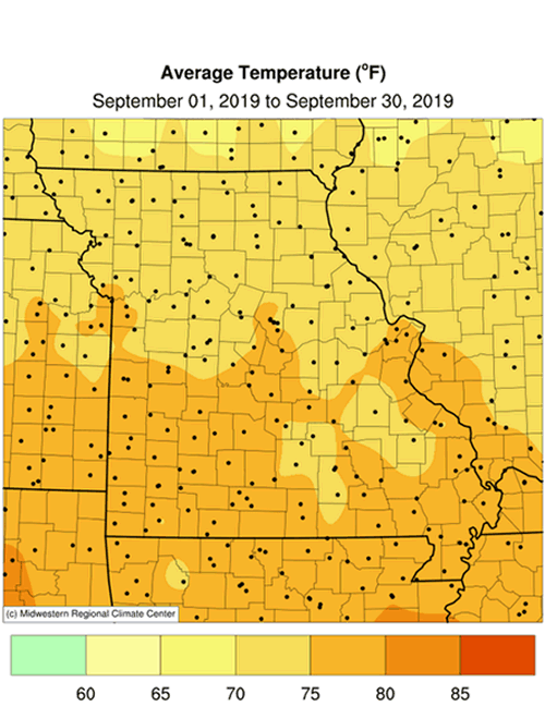
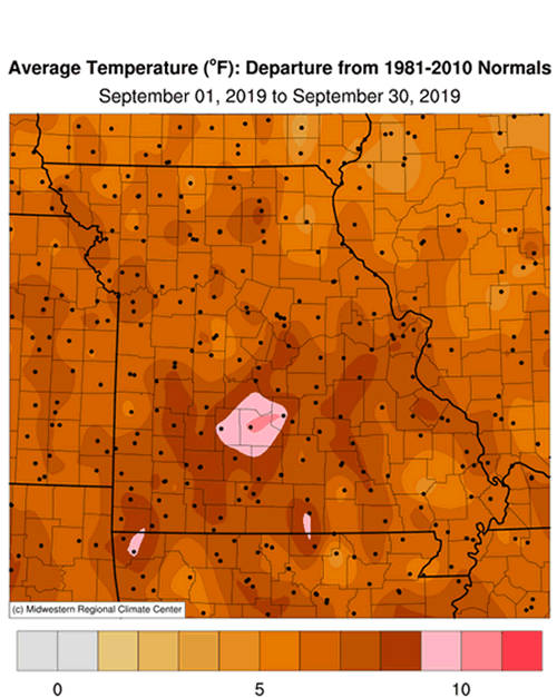
Record heat impacted the Show Me State in September with above normal temperatures dominating. Some locations experienced their warmest September on record including Springfield, West Plains, St. Louis and Columbia (tied with 1897), Figure 1. Preliminary data indicate the statewide average temperature for September was 74.7°F, or 6.4° above the long-term average. The ranking may change slightly, but at press time it was the 2nd warmest September on record for Missouri and the warmest September since 1931, Figure 2.
September acted more like August with daily high temperatures reaching the 80’s and 90’s and minimum temperatures dropping into the 60’s and 70’s. Preliminary data for the month indicate the statewide average minimum temperature was 63.8°, or 7.5° above average. It was the highest statewide average minimum temperature on record for September, Figure 3.
Minimum temperatures remained high throughout the month due, in part, to high dew point temperatures. The average dew point temperature for Columbia during September was 64.6°F and ranked as the highest on record for the month, Figure 4. For the year, so far, September has the highest temperature departure from average, Figure 5.
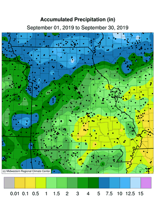
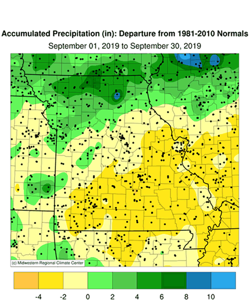
September precipitation was highly variable across Missouri with above average rainfall in northern and west central sections and below average amounts impacting central, east central and southern portions. The average statewide preliminary monthly total was 3.58 inches, or 0.49 inches below the long-term average. It was the third consecutive drier than average September for the state, Figure 6, and the first drier than average month since April, Figure 7.
According to radar estimates and ground truth reports, 5-7 inches were common over northern and west central Missouri with an area of 8-10 inches impacting several far north central and northeastern counties, Figure 8. Generally, 2-4 inches occurred across central sections and less than 2-inches were reported over some southwestern counties and many east central, south central and southeastern counties. Numerous pockets of unusual dryness were found over several south central and southeastern counties where less than 0.5 inches were reported for the month. Some of the lightest and heaviest rain gauge reports for September are listed in Table 1.
| September 2019 | |||
| Station Name* | County |
Rainfall (in.) | |
| Lightest | Alton 1.7NNW | Oregon | 0.19 |
| Houston 5.0SE | Texas | 0.25 | |
| Mountain Grove 14.0S | Douglas | 0.35 | |
| Charleston 5S | Mississippi | 0.43 | |
| Dexter 0.6WNW | Stoddard | 0.51 | |
| Heaviest | Kirksville Airport | Adair | 11.34 |
| Princeton 1.4NNE | Mercer | 11.15 | |
| Spickard 7W | Grundy | 10.76 | |
| Stanberry 4.4NE | Gentry | 10.61 | |
| Milan 1.2SW | Sullivan | 10.58 | |
| *Rain gauges are from the NWS Cooperative Network, CoCoRaHS Network, Missouri Mesonet | |||
| Table 1. | |||
The U.S. Drought Monitor map for October 1, 2019 showed abnormally dry to moderate drought affecting portions of south central and southeastern Missouri, Figure 9. It was the first time this year a drought status category was depicted for a portion of Missouri.
According to the Missouri Agricultural Statistics Service, as of September 29, 2019, the majority of the corn crop was in good condition at 41% compared to 23% last year. This year, 5% of corn was reported to be excellent compared to 5% last year. Remaining corn conditions this year were 33% fair, 16% poor and 5% very poor. Corn harvest was behind schedule at 26% compared to the 5-year average of 47%. Half of the soybean crop this year was reported in good (44%) to excellent (6%) condition compared to 35% good and 9% excellent at the same time last year.
The majority of hay and roughages were adequate (70%) to surplus (6%) this year with 22% short and 2% very short. Stock water supplies were mostly adequate at 91%, with 4% surplus and 5% short. The majority of pastures were reported in good (58%) to excellent (10%) condition while only 7% were in poor or very poor condition. The majority of topsoil moisture conditions were adequate (62%) or surplus (17%), while 18% were reported short and 3% very short. The majority of subsoil moisture conditions were also reported to be adequate (80%) to surplus (11%) with 8% short and 1% very short.
Most sections of the Missouri will experience their first fall frost during October, Figure 10. Using climatology, the northern quarter of Missouri and eastern Ozarks will generally experience a light freeze (32°F or cooler) by mid-October. Central Missouri and the western Ozarks will experience a light freeze by October 21st, and a few days later in urban areas. The Bootheel will have a light freeze typically toward the end of October or early November. For more information on frost/freeze probabilities for Missouri, including additional temperature thresholds, please visit the following link: http://ipm.missouri.edu/FrostFreezeGuide.
Jump to:
- Figure 1
- Figure 2
- Figure 3
- Figure 4
- Figure 5
- Figure 6
- Figure 7
- Figure 8
- Figure 9
- Figure 10
- Figure 11
- Figure 12
- Figure 13
- Figure 14
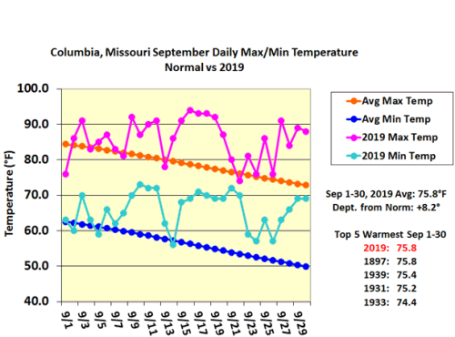
Figure 1.
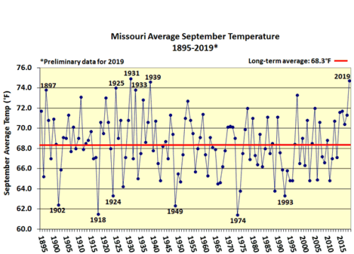
Figure 2.
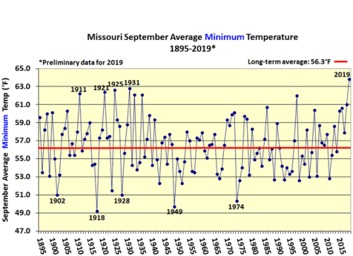
Figure 3.
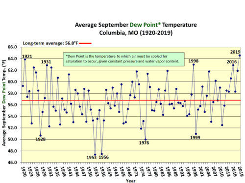
Figure 4.
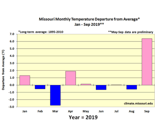
Figure 5.
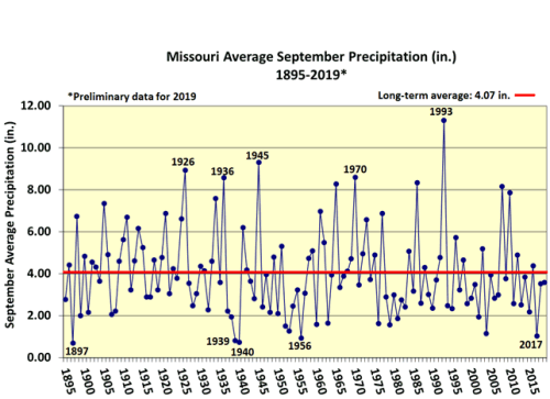
Figure 6.
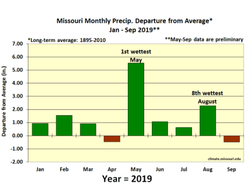
Figure 7.
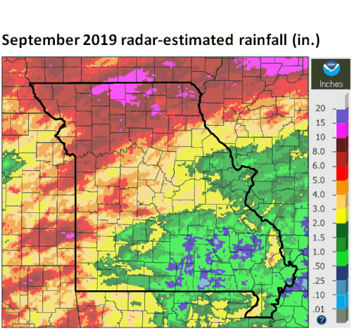
Figure 8.
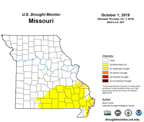
Figure 9.
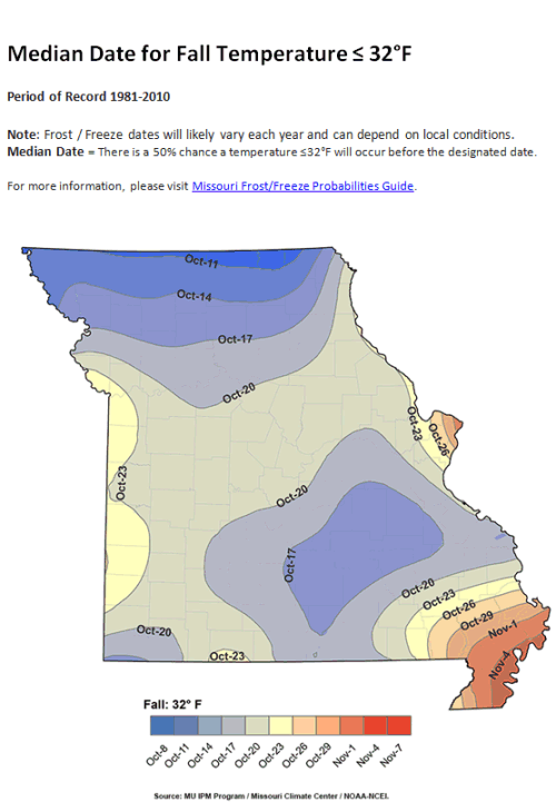
Figure 10.
Source: Pat Guinan, 573-882-5908