
August 2014 Weather and Its Impacts on Missouri
Pat Guinan
State Climatologist
Commercial Agriculture/University of Missouri Extension
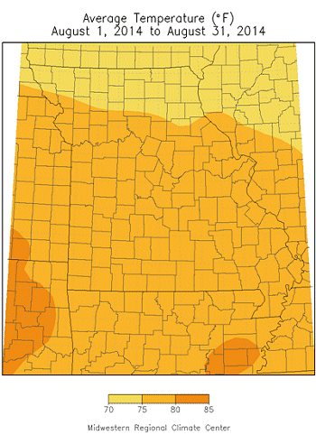
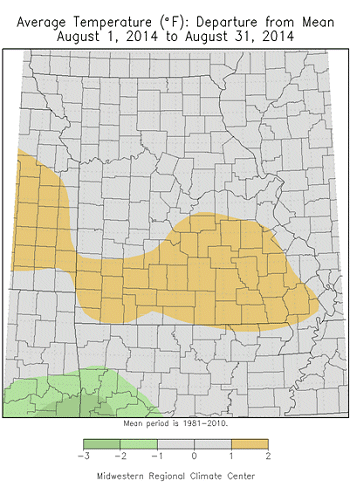
Temperatures trended cooler than normal during the first half of August, but a hotter weather pattern emerged during the latter half of the month, including a late summer heat wave and some of the highest temperatures for the year. Using Columbia, MO as a midpoint for the state, Figure 1 shows daily maximum and minimum temperatures for August compared to normal. Preliminary data indicate a statewide average temperature of 76.3°, or 0.3 degrees above normal. It was the 7th month since January 2013 to average above normal, Figure 2, however, it was a marginally warm August, and near average would be a more fitting term, Figure 3.
A late summer heat wave toward the end of the month included triple digit heat across southern sections during August 24-26. Some of the highest temperatures observed for the month, and year, include:
| Location | County | Max Temp (°F) | Date |
| Eminence 1N | Shannon | 106 | 8/25 |
| Protem 4NE | Taney | 104 | 8/24 |
| Round Spring | Shannon | 104 | 8/25 |
| Poplar Bluff | Butler | 104 | 8/25 |
Even though June and August this year averaged slightly warmer than normal, the unusually cool July temperatures resulted in an overall cooler than average summer, Figure 4.
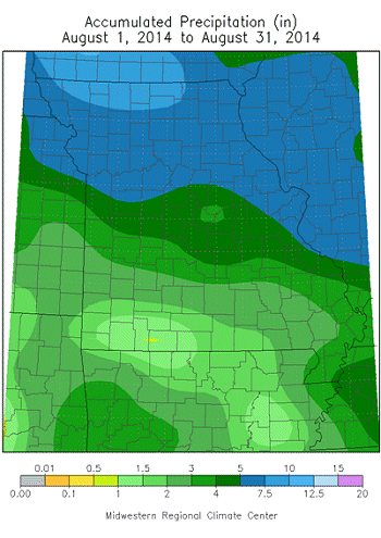
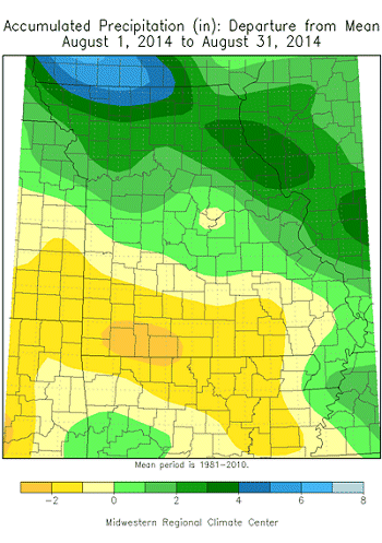
August rainfall was variable across the Show Me state, ranging from above normal over northern sections, near normal in central, and mostly below normal across southern Missouri. Preliminary data indicate an average statewide total of 4.40 inches, or nearly 0.75" above the long-term average. It has been an unusual growing season, not only with monthly summer temperature disparities, but also with alternating months of above and below normal precipitation since March of this year, Figure 5.
As the month progressed, northern sections became wetter while southern Missouri turned drier. The Drought Monitor map depicted much of southwestern and south central Missouri experiencing abnormally dry to moderate drought conditions toward the end of the month, Figure 6. August totals generally ranged from 5-8 inches across northern Missouri, 3-5 inches over central sections and the Missouri Bootheel, to 1-3 inches over southern sections. Some of the highest and lowest reports include:
| Location | County | August Rainfall (in.) |
| Grant City 5WSW | Worth | 13.66 |
| Maryville 2E | Nodaway | 13.36 |
| Green City | Sullivan | 12.73 |
| Arnold 1N | Jefferson | 11.93 |
| Tarkio #2 | Atchison | 11.11 |
| Eminence 1N | Shannon | 1.03 |
| Poplar Bluff | Butler | 1.06 |
| Joplin Reg. AP | Jasper | 1.52 |
| Lockwood | Dade | 1.60 |
| Round Spring | Shannon | 1.68 |
Grant City and Maryville have established long-term daily precipitation records beginning 1893 and 1894, respectively, and reported their wettest August on record.
Widespread and significant precipitation events during the month include an event that impacted much of the state on August 6-7, and another event with localized flash flooding affecting northern and east central sections on August 15-16.
Generally, much of the state between Highway 36 and Interstate 44 received 1-3 inches of rain on August 6-7, Figure 7. Antecedent soil moisture conditions were dry at the time, and crops and pastures benefitted tremendously. It is notable that parts of Callaway, Osage, and Maries counties received lesser amounts during this event, and dryness persisted in this localized area.
During the overnight hours of August 15-16, flash flooding occurred across parts of Nodaway, Worth and Gentry counties due to intense rainfall over a 4 to 6 hour period. Some observers reported 6-7 inches of rain with numerous roads closed due to flooding. The Farm Service Agency office in Albany reported 6.90 inches during the storm.
According to the Missouri Agricultural Statistics Service report for the week ending August 25, 2014, 63% of the state reported topsoil moisture supplies in adequate to surplus condition. Corn and soybean conditions were similar to end of July conditions with 83% and 76% in good to excellent condition, respectively. Pasture conditions had declined to 36% in good to excellent condition. Hay and other roughages were 93% adequate to surplus and 83% of stock water supplies were also adequate to surplus.
Jump to:
- Figure 1
- Figure 2
- Figure 3
- Figure 4
- Figure 5
- Figure 6
- Figure 7
- Figure 8
- Figure 9
- Figure 10
- Figure 11
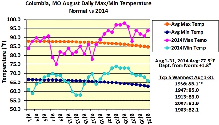
Figure 1.
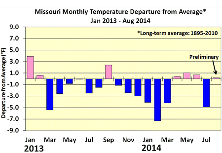
Figure 2.
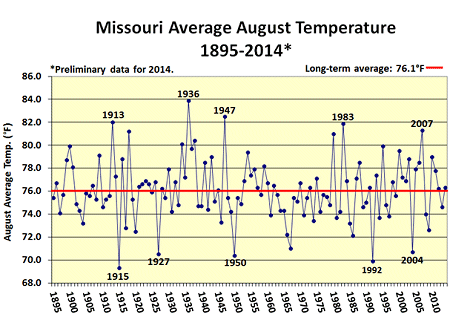
Figure 3.
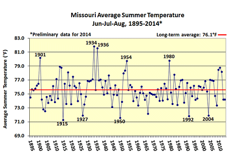
Figure 4.
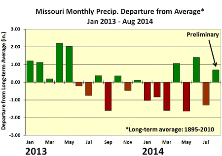
Figure 5.
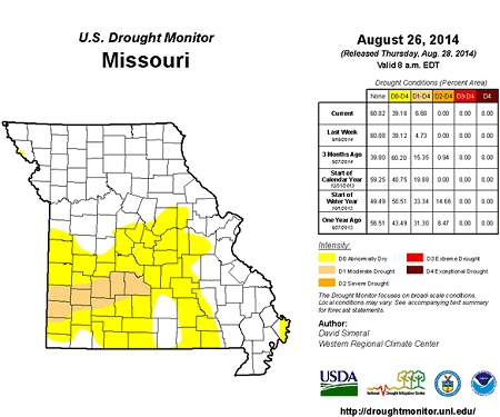
Figure 6.
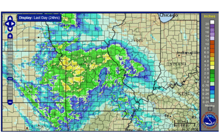
Figure 7.: Radar Estimated Rainfall for August, 6-7, 2014. NOAA/NWS
Source: Pat Guinan, 573-882-5908