
August 2018 Weather and Its Impacts on Missouri
Pat Guinan
State Climatologist
University of Missouri Extension
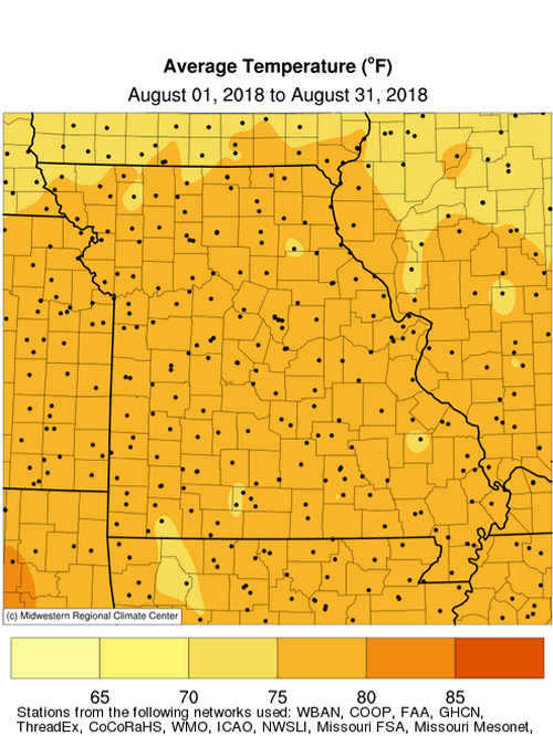
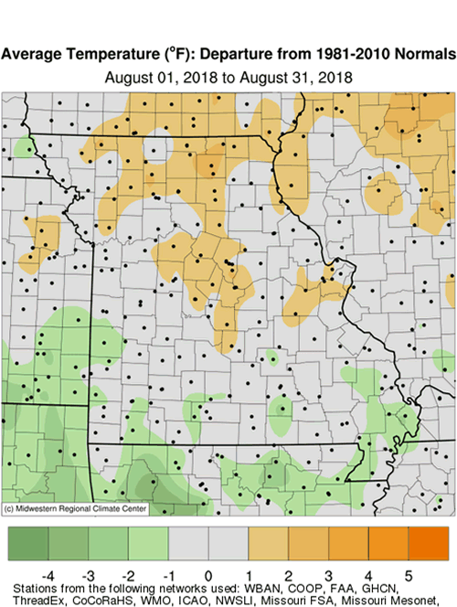
Above normal temperatures occurred during the first half of August in Missouri, and with the exception of a 4-day heatwave, cooler maximum temperatures dominated for the remainder of the month due to cloudier weather. Preliminary data indicate the statewide average temperature for August was 76.4, or 0.3 degrees above the long-term average, Figure 2. It was the 4th consecutive month with above average temperatures, Figure 3. For the summer season (Jun-Jul-Aug), 2018 was the 17th hottest on record, Figure 4. More notably, the May through August average temperature was 76.1°F, or 3.3 degrees above the long-term average, making it the 3rd hottest on record, and hottest May-August period since 1936, Figure 5.
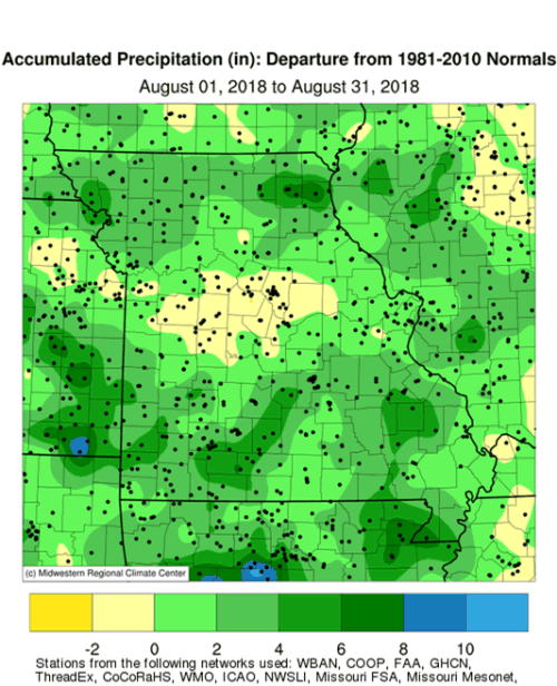
A wetter pattern emerged by mid-August and persisted for the rest of the month, bringing much needed relief to drought-stricken Missouri. Preliminary data indicate a statewide average of 5.50 inches, or 1.80 inches above the long-term average. It was the sixth consecutive wetter than average August, Figure 6, and it was the first wetter than average month since March, Figure 7.
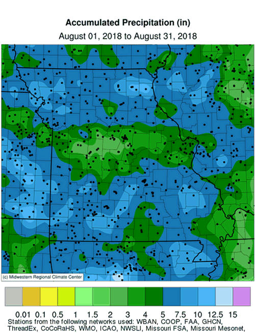
Typical of the summer season, August rainfall was highly variable, ranging from less than 3 inches to more than 10 inches, Figure 8. However, for the majority of locations, rainfall was above average, Figure 9. Heaviest amounts occurred over northern and southern sections. Lowest totals were confined to west central and east central Missouri and a few far south central counties, as well as northern portions of the Missouri Bootheel. Some of the lightest and heaviest monthly totals are listed in Table 1.
| MISSOURI | |||
| Station Name* | County |
Rainfall (in.) | |
| Lightest | Warrensburg 1.1NNE | Johnson | 1.52 |
| Green Ridge 0.3NNW | Pettis | 1.90 | |
| California 0.3SW | Moniteau | 2.01 | |
| Boonville 3.7SE | Cooper | 2.34 | |
| Stover 2.3NW | Morgan | 2.35 | |
| Heaviest | Monticello 0.4SSW | Lewis | 13.42 |
| Edina 2.3E | Knox | 11.51 | |
| Farmington 1.5WSW | St. Francois | 10.73 | |
| Hornersville | Dunklin | 10.56 | |
| Oregon | Holt | 10.26 | |
| *Rain gauges are from the NWS Cooperative Network or CoCoRaHS Network | |||
| Table 1. | |||
Two localized but extreme rain events impacted the state during the month. Intense rainfall occurred across far southern portions of the Bootheel on Aug 15-16. A Missouri Mesonet rain gauge, near Senath, reported 7.55 inches over a 10-hour period beginning 10 p.m. CST, Aug 15, and ending 8:00 a.m. CST, Aug 16. The Senath gauge reported a total of 8.10 inches on Aug 16. Another extreme rain event impacted a few northeastern counties during the early a.m. hours of Aug 24. A CoCoRaHS observer 2.3 miles east of Edina, in Knox County, reported 6.57 inches. A NWS Coop observer located in Edina reported 6.39 inches. A CoCoRaHS observer near Monticello, in Lewis County, reported 5.92 inches during the morning of Aug 24.
Drought impacts continued to intensify and accumulate, especially during the first half of August. Impacts from the prolonged growing season heat and dryness included mounting crop and pasture losses, livestock stress, and declining water supplies. Numerous cattle were being culled due to insufficient feed supplies. Hydrological issues such as dry wells and stream beds, low rivers and lake levels, empty ponds, and water restrictions were increasingly common. The extreme conditions were adversely affecting gardens, lawns, trees and shrubs with instances of vulnerable species succumbing to water stress. Wetter conditions during the latter half of August began to mitigate some of the impacts with some greening up of pastures and lawns and slight recovery in topsoil moisture and surface water supplies.
In mid-August the U.S. Drought Monitor map showed 83% of Missouri experiencing drought, Figure 10. Worst conditions were impacting portions of northern, central and southwestern Missouri. Significant rain events during the second half of August led to improving drought conditions, and, by the end of August, just over 65% of the state was in drought, Figure 11.
According to the Missouri Agricultural Statistics Service report for the week ending September 2, 2018, nearly half the state, 48%, reported topsoil moisture supplies in short to very short condition and 66% of subsoil moisture supplies were in short to very short condition. Corn was reported 40% in poor to very poor condition compared to 9% at the same time last year. Soybean was 28% in poor to very poor condition compared to 8% last year. Pastures were rated at 54% in poor to very poor condition compared to 6% last year. Hay and other roughages were 79% short to very short, and 50% of the stock water supplies were short to very short.
In order to document the impacts of drought and provide an opportunity for Missourians to contribute information, the Missouri Climate Center partnered with representatives of the National Integrated Drought Information System (NIDIS) and National Drought Mitigation Center (NDMC) to develop an online survey for reporting drought impacts in Missouri. The survey is named Missouri Extension Drought Impact Reporter and was launched on July 6, 2018. The information is critical for assessing drought severity in Missouri and can be used by decision makers at the state and national level, including the authors of the U.S. Drought Monitor map.
If you’d like to submit a drought impact report, or picture, please visit Missouri Extension Drought Impact Reporter and fill out a short survey.
For more information on the survey, please visit http://climate.missouri.edu/news/arc/jun2018a.php.
Jump to:
- Figure 1
- Figure 2
- Figure 3
- Figure 4
- Figure 5
- Figure 6
- Figure 7
- Figure 8
- Figure 9
- Figure 10
- Figure 11
- Figure 12
- Figure 13
- Figure 14
- Figure 15
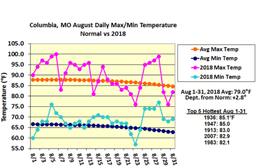
Figure 1.
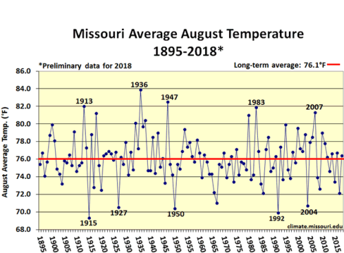
Figure 2.
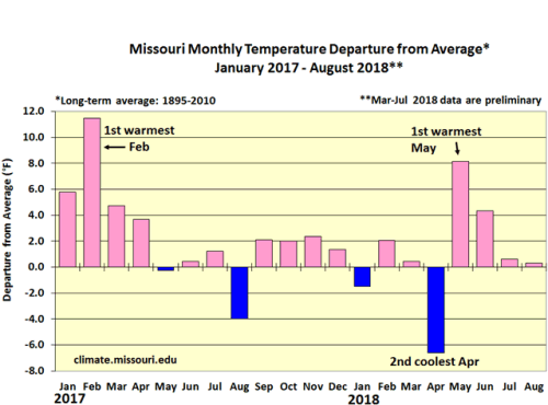
Figure 3.
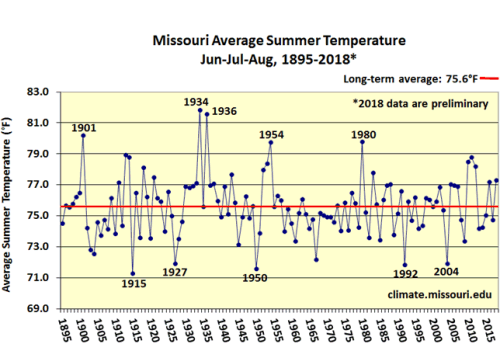
Figure 4.
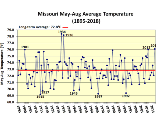
Figure 5.
Figure 6.
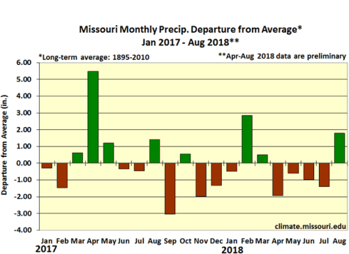
Figure 7.
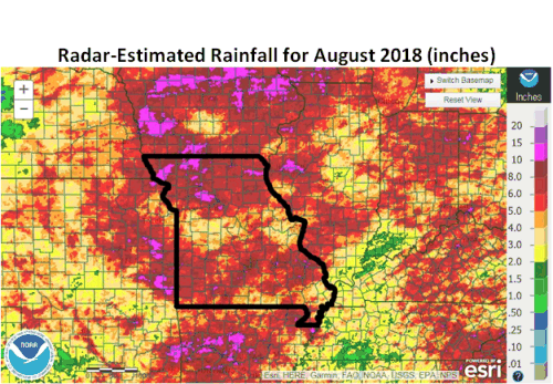
Figure 8.
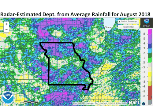
Figure 9.
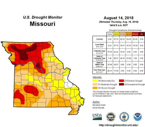
Figure 10.
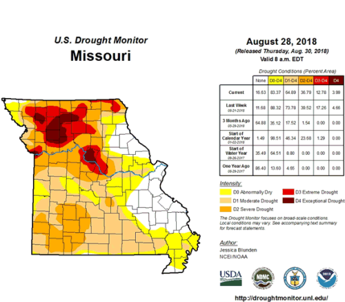
Figure 11.
Source: Pat Guinan, 573-882-5908