
August 2023 Weather and Its Impacts on Missouri
Dr. Pat Guinan
Climatologist
MU Extension Associate Professor Emeritus
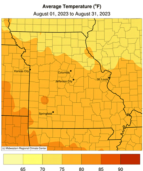
Slightly above average daily August temperatures impacted Missouri with preliminary data indicating a statewide average temperature of 76.5°F, or 0.5° above the long-term average, Figure 1. The most notable feature during the month was an intense 6-day heat wave that impacted the state from August 20-25, Figure 2. Seasonably cool conditions prevailed the rest of the month. Every month this year has been warmer than average, Figure 3.
Preliminary mean summer temperature data (Jun-Jul-Aug) indicate above normal conditions this year, Figure 4. The statewide average summer temperature was 76.1°F, 0.6° above the long-term average. It was the 4th consecutive hotter than average summer. Summer weather patterns over the past several decades indicate less variance in maximum temperature trends, Figure 5, whereas minimum summer temperatures indicate notable warming, Figure 6. This phenomenon is primarily due to above average summer dew point temperatures in Missouri, Figure 7, which act to suppress maximum air temperature and elevate minimum air temperature.
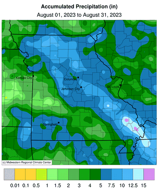
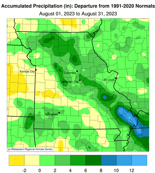
Above average rainfall impacted Missouri in August with preliminary data indicating a statewide average of 6.30 inches, 2.59 inches above the long-term average. The month tied with 1902 for being the 6th wettest August on record, and it was the first wetter than average month since March, Figure 9. Most of the rain occurred during the first half of the month.
Typical of the summer season, August rainfall was highly variable, ranging from less than 1-inch to more than 18-inches, according to rain gauge observations. Radar-estimates for the month indicate heaviest rainfall across the northeastern half of the state and a small portion of southwestern Missouri, Figure 10. Drier conditions occurred over a small portion of west central and far south central sections. Some of the lightest and heaviest August rain gauge reports are listed in Table 1.
The U.S. Drought Monitor, for the last week of August, showed drought in much of Missouri despite the wetter than average conditions for the month, Figure 11. Drought has impacted much of the Show Me state during the growing season and significant deficits have accumulated, Figure 12. Most impacts have been agriculture related, with reports of crop, pasture, and livestock losses. Hydrological impacts were also reported in the form of diminished water supplies above and below the ground.
According to the Missouri Agricultural Statistics Service report for the week ending August 27, 2023, 59% of the state reported topsoil moisture supplies in adequate condition with 3% surplus, whereas 31% of Missouri reported short topsoil moisture supply and 7% very short. Subsoil moisture supplies were reported 48% adequate and 3% in surplus condition compared to 35% of the state reporting subsoil moisture supplies short and 14% very short. Corn was reported 41% in good to excellent condition compared to 52% last year. Soybean was reported 49% in good to excellent condition compared to 54% last year. Pastures were rated at 20% good and 0% excellent compared to 30% good and 2% excellent last year. Hay and other roughages were 41% very short, 33% short, 26% adequate and 0% surplus. Stock water supplies were 5% very short, 26% short, 69% adequate and 0% excellent.
| Missouri High and Low Rainfall Extremes for August 2023* | |||
| Station Name* | County | Rainfall (in.) | |
| Heaviest | |||
| Marble Hill 0.4 NE | Bollinger | 18.33 | |
| Anniston 1.9 WNW | Mississippi | 16.08 | |
| Sikeston 1.7 ENE | Scott | 16.01 | |
| Potosi 4 SW | Washington | 15.78 | |
| Kirksville 1.6 N | Adair | 14.34 | |
| Lightest | |||
| Osceola | St. Clair | 0.78 | |
| Eldorado Springs | Cedar | 1.19 | |
| Pomme De Terre Dam | Hickory | 1.31 | |
| Butler 0.6 S | Bates | 1.52 | |
| Nevada Water Plant | Vernon | 1.61 | |
| *Rain gauges are from the NWS Cooperative Network or CoCoRaHS Observers. | |||
| Table 1. | |||
In addition to the drought, another extreme event during the summer of 2023 was a 6-day heat wave from August 20-25. The event was stressful for people, pets, livestock and various plants exposed to highly uncomfortable outdoor conditions, including indoor structures without air conditioning. The consecutive string of hot temperatures, especially high minimum temperatures, combined with unusually high dew points was exceptional. For example, from Aug 20-25, 2023, Columbia Regional Airport observed six consecutive days with minimum temperatures ≥75°F. The last time this occurred at the airport was over 40 years ago, during a 9-day period from July 4-12, 1980. A comparable multi-day heat wave with high temperatures and dew points occurred nearly 30-years ago and impacted Missouri and other Midwestern states from July 12-15, 1995.
This year, through August 31, the Columbia Regional Airport reported heat indices ≥110°F for 21 hours, all occurring between August 20-25. Using hourly airport records since 1973, 2023 ranks second at Columbia Regional Airport for the highest annual number of heat index hours ≥110°F, Figure 13. Only 1995 reported more heat index hours (25) ≥110°F at the airport.
More than 1,000 people perished during the July 1995 heat wave, mostly in large Midwestern cities, but far fewer casualties were reported this year due, in part, to heat wave action plans developed in response to the 1995 event.
Jump to:
- Figure 1
- Figure 2
- Figure 3
- Figure 4
- Figure 5
- Figure 6
- Figure 7
- Figure 8
- Figure 9
- Figure 10
- Figure 11
- Figure 12
- Figure 13
- Figure 14
- Figure 15
- Figure 16
- Figure 17
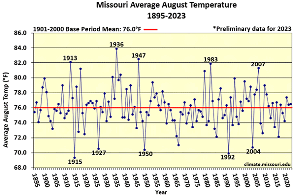
Figure 1.
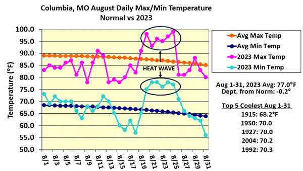
Figure 2.
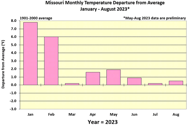
Figure 3.
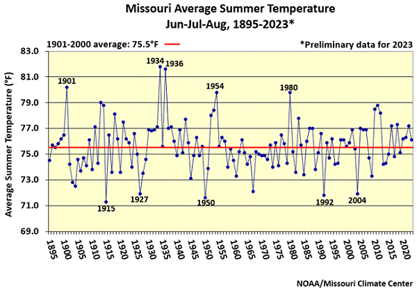
Figure 4.
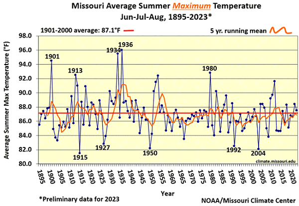
Figure 5.
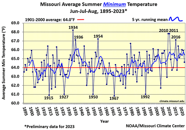
Figure 6.
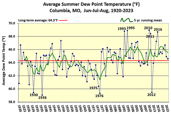
Figure 7.
Figure 8.
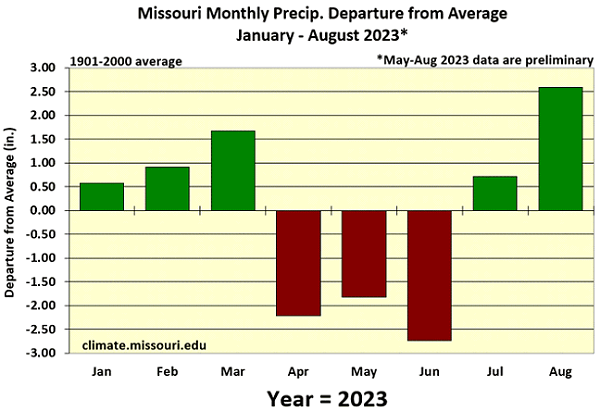
Figure 9.
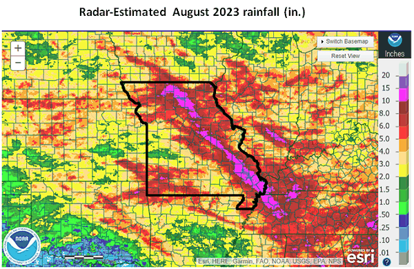
Figure 10.
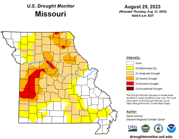
Figure 11.
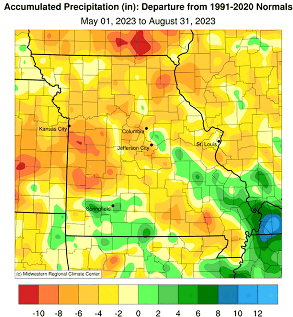
Figure 12.
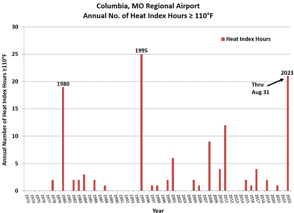
Figure 13.
Source: Dr. Pat Guinan, 573-882-5908