Missouri Summer 2010 Weather Summary
Pat Guinan
State Climatologist
Commercial Agriculture/University of Missouri Extension
Preliminary numbers are indicating the summer of 2010 will go down as hotter than normal for all of Missouri with varying amounts of precipitation, ranging from excess to drought.
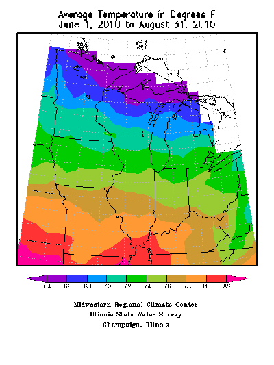
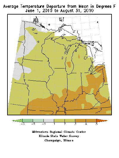
June, July and August were all warmer than normal averaging 4.4, 1.6 and 3.3°F above normal, respectively. Overall, the average summer temperature was 78.5°F, or 3.1°F above normal. Three consecutive months of above normal temperatures resulted in this summer being the ninth hottest in the past 116 years and the hottest since 1980. Individually, June ranked as the eighth warmest and July and August each ranked as the 19th warmest on record.
Some notable characteristics of this summer were unusually high dewpoint temperatures, which translated to extended periods of above-normal minimum temperatures. For example, preliminary data indicates the average dewpoint temperature in Columbia, MO, this summer was 69.0°F, which makes it the highest on record when comparing to dewpoint observations since 1948. The second highest average summer dewpoint temperature for Columbia was 68.9°F in 1995.
Additionally, Columbia experienced only 12 days during the 3-month period when minimum temperatures fell below normal. The average minimum temperature for Columbia was 68.3°F, or 4.3°F above normal, whereas the average maximum temperature was 87.5°F, or 0.9°F above normal. These air temperatures, in combination with unusually high dewpoint temperatures, led to several uncomfortable days and extended periods of high heat indices that have not been seen in more than a decade.
The heat was more intense across southern sections of the state where drought conditions evolved and persisted for much of the summer, especially across southeastern sections. Some communities in the Bootheel experienced 10 days with triple digit heat this summer and 69 days with temperatures ≥90°F.
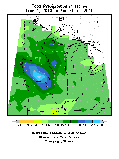
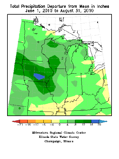
Summertime rainfall was variable across the state from month to month, but overall, statewide average precipitation for June and July totaled 4.59 and 6.59 inches, respectively, and was above normal for both months. August rain events were infrequent and averaged 2.75 inches, or just under 1-inch below normal. The combined summertime average was 13.93 inches, which is 2.14 inches above the statewide seasonal norm.
Regionally, precipitation extremes for June ranged from 8-12 inches across northern Missouri to less than 1-inch over portions of southeastern Missouri. The community of Kahoka, in far northeastern Missouri, reported 14.36 inches for June whereas the town of Bloomfield, in southeastern Missouri, reported no measureable rainfall during the entire month of June.
July extremes varied from 7-12 inches over much of central and northeastern Missouri to less than 3 inches in some southeastern communities. Hannibal reported their second wettest July on record with a whopping 17.26 inches. Statewide, the month ranked as the eighth wettest July on record.
Drier conditions prevailed in August with extended periods of no rainfall and abundant sunshine. Southern sections of the state experienced the driest conditions where generally less than 2-inches of precipitation were reported. Caruthersville, MO, reported no precipitation for the entire month. Localized dryness was also reported in some northwestern counties. Heaviest August rainfall occurred over central sections where 3.5-5.0 inches were common.
Overall, June through August rainfall totals ranged from more than 25 inches in northeastern sections to less than 4 inches over parts of the Missouri Bootheel. Kahoka, MO, reported 29.10 inches for the summer, whereas a paltry 3.10 inches was observed in the Bootheel community of Kennett, MO.
The latest autumn outlook as issued by the Climate Prediction Center for the months of September, October and November calls for above normal temperatures across all of Missouri. Below normal precipitation is forecast for all of the Show-Me state with the exception of far northwestern sections where equal chances of above, below and near normal precipitation are anticipated.