September 2010 Weather and Its Impacts on Missouri
Pat Guinan
State Climatologist
Commercial Agriculture/University of Missouri Extension
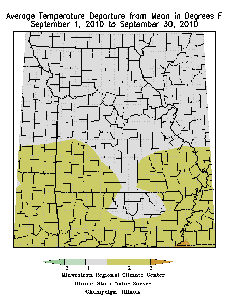
Preliminary September weather data for Missouri were indicating an average statewide temperature of slightly less than one degree above normal. Regionally, seasonably mild conditions were dominant over central and southern sections where monthly average temperatures ranged 1 to 1.5° above normal. Northern portions of the state experienced near normal monthly temperatures ranging from slightly below normal to about 0.5° above normal. Daily maximum temperatures were mostly in the 70’s and 80’s with minimum temperature in the 50’s and 60’s. There were no extended hot periods during the month and only a handful of days when a few locations reported temperatures in the lower 90’s. Coldest minimum temperatures occurred during the last week of the month with most areas dipping into the 40’s on the morning of the 27th. The northwestern community of Hamilton, MO dipped to 39° on the September 27.
An active and progressive weather pattern dominated much of the month as several frontal boundaries swept through the state and brought frequent wet periods. There were several significant rain events but the most notable one occurred on September 1st when several southwestern Missouri counties reported 3-6 inches of rain. Portions of northern Christian and southern Greene counties recorded more than 8-inches and a CoCoRaHS observer residing close to the Christian/Greene county line, near the community of Ozark, MO, reported a whopping 24-hour total 10.21 inches. The National Weather Service office in Springfield received 4.62 inches which was the second greatest 24-hour rainfall total for September. Another round of storms on the 2nd exacerbated the situation with continued flash flooding. There were numerous reports of flooded low water crossings and county roads in the area as well as overflowing rivers and streams. Two dozen water rescues were conducted in Christian county alone, but no casualties were reported with this event.
Two significant severe weather episodes impacted parts of the Show Me state during the month. On September 15 several rounds of thunderstorms impacted portions of southwestern Missouri with microburst wind damage to residential property and vehicles. One EF0 tornado with 80-85 mph winds touched down 4.5 miles southwest of Nixa, MO and tracked northeast for 0.5 miles. The path width was 100 yards wide but only tree damage was reported.
Another notable severe storm event impacted parts of west central and northeastern Missouri during the afternoon and evening of September 18th. Particularly hard hit was the Kansas City metropolitan area when severe thunderstorms dropped hail as large as softballs (4.5” in diameter). Some hail stones were reported to be 5.5 inches in diameter which caused substantial vehicle damage in and around Independence Center.
According to a storm event report issued by the Pleasant Hill National Weather Service office, 5-inch diameter hail is highly unusual in Missouri. There have been only 5 occurrences reported since 1950 and it is unprecedented for the month of September. Microbursts were also reported in and around Kansas City with significant property damage reported at Smithville Lake when 80 mph winds struck the area. Other large hail incidents, 1.00-1.75” diameter, were reported over parts of northeastern Missouri when a supercell thunderstorm tracked southeastward through Adair, Macon, Shelby and Monroe counties.
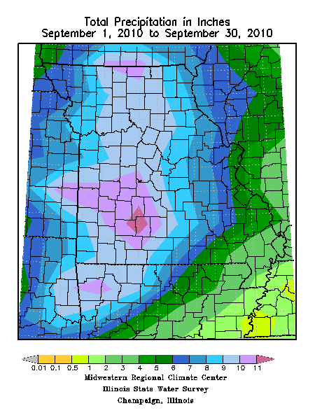
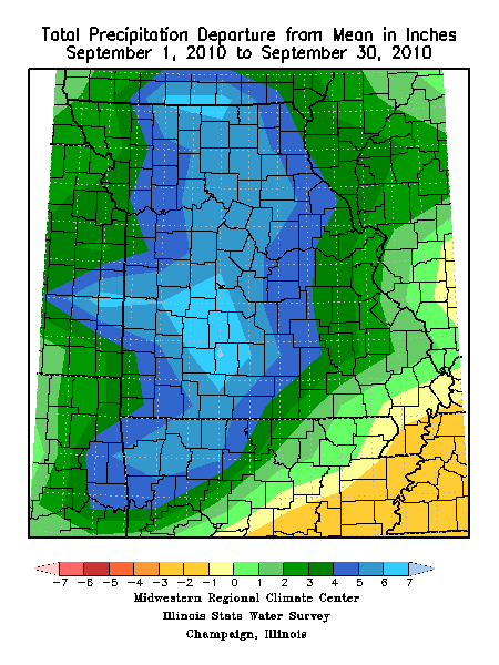
Rainfall was nearly 4 inches above normal for the monthly with preliminary data indicating a statewide average of 8.46 inches. It was the 5th wettest September on record and the wettest September since 1993. All areas of the state experienced above normal rainfall with the exception of the Bootheel. Excluding the northwestern tip, the western 1/3 of Missouri reported highest monthly totals between 8-12 inches, whereas the Bootheel averaged less than 3 inches. A few counties in southwestern Missouri reported more than 14 inches of rain for the month with a couple communities in Christian and Greene counties reporting nearly 19 inches. Alternatively, two Bootheel locations, Kennett and Caruthersville, reported less than 1-inch for the entire month.
The wet weather during September hindered fieldwork activity over much of the state but drier conditions in southeastern Missouri allowed producers to virtually complete corn harvest by the end of the month according to the Missouri Agricultural Statistics Service. Soybean harvest was just beginning and the initial start of winter wheat planting was running behind due to the muddy conditions.
South central and southeastern sections of the state were still experiencing lingering impacts of summer drought with well over half of the pastures reported in poor to very poor condition. Substantial yield loss was reported in generally all pastures across portions of south central and southeastern Missouri and many farmers were already feeding hay. According to an Extension specialist in Oregon county, some beef producers were weaning calves early because the cows were not providing enough milk and were losing body condition.
During this time of year concerns arise over the prospects of freezing temperatures occurring in Missouri. Most sections of the state will experience their first fall frost during October. Using climatology, the northern quarter of Missouri and eastern Ozarks will experience a light freeze (32° or cooler) as early as October 10 on 5 out of 10 years. Central Missouri and the western Ozarks will experience a light freeze on 5 out of 10 years by October 15. The Bootheel will have a light freeze on 5 out of 10 years by October 30. A map displaying the average date of first fall frost in Missouri can be found at the following web link: http://agebb.missouri.edu/weather/frost2.htm