August 2012 Weather and Its Impacts on Missouri
Pat Guinan
State Climatologist
Commercial Agriculture/University of Missouri Extension
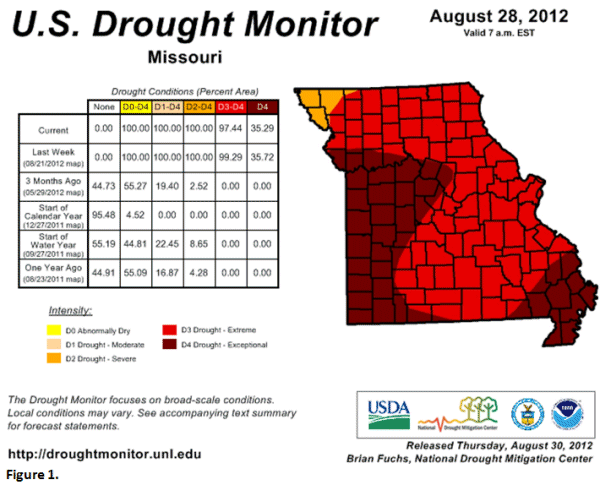
The historic drought impacting Missouri intensified over portions of the Show Me state in August where, according to the 8/28/2012 Drought Monitor map, 97.44% of the state was in extreme (D3) or exceptional drought (D4), Figure 1. Significant and widespread moisture relief was not realized until the remnants of Hurricane Isaac moved northward from Louisiana and Arkansas into southern Missouri on the last day of August. Much of the state reported substantial precipitation from Isaac over Labor Day weekend.
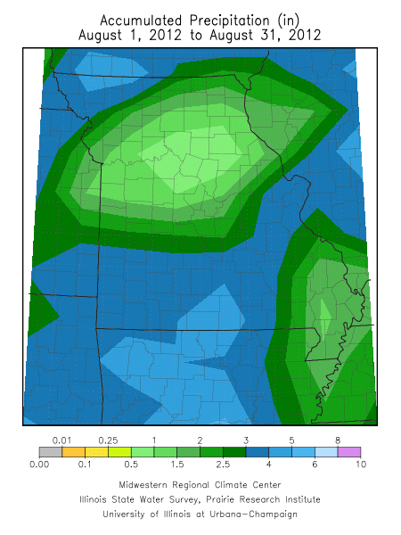
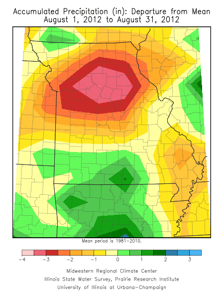
The statewide precipitation average for August was 2.33 inches, or 1.3 inches below normal. Lowest August totals were concentrated across central Missouri where many locations reported less than 1-inch for the month. Some lower amounts, less than 0.5 inches, were reported in Chariton, Howard, Cooper, Moniteau, Miller, Randolph, Boone, Cole, Monroe, Audrain, Callaway and Ralls counties. Sanborn Field, located on the University of Missouri-Columbia campus, reported 0.11 inches for the month. A few reports of less than 0.50 inches also occurred in far southeastern Missouri, in Cape Girardeau, Mississippi and New Madrid counties. Only south central, southwestern, and a small portion of far northwestern Missouri reported above normal rainfall for the month.
Prior to Isaac, portions of Missouri were recipients of significant rain events that brought temporary drought relief. Most notably, rain impacted southwestern, south central and east central sections on the 4th of the month where 0.5-1.5 inches were common. Another round of showers and thunderstorms dropped 0.5-1.5 inches in south central Missouri on August 16th. Northwestern Missouri, and a few southwestern counties, experienced 0.5-2.0 inches on 8/25-26 with localized amounts between 2-8 inches reported in Atchison, Holt and Nodaway counties. Some of the heaviest monthly totals include Marshfield (6.39"), Salem (6.56"), Mound City (6.59"), Ava (6.66"), Washington (6.80"), Fairfax (8.34") and Tarkio (9.42"). Tarkio received 8.49" on 8/25-26, with 7.01" inches reported on 8/26.
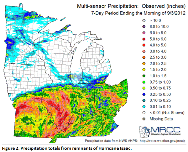
Precipitation enveloped a large part of Missouri on 8/31 as Isaac remnants spiraled northward into the Show Me state. The tropical depression lingered in Missouri for much of Labor Day weekend and brought widespread drought relief in the form of a steady rain falling over multiple hours (Figure 2.)
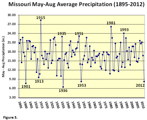
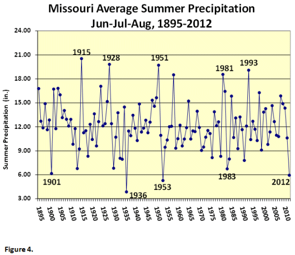
Preliminary data indicate the May through August average statewide rainfall total was 8.23 inches, nearly 9 inches below the long-term normal. It was the 3rd driest May-August period on record and the driest since 1936. May-August 2012 was 0.01" drier than the same period in 1953 (Figure 3). Average statewide precipitation for the summer period, Jun-Jul-Aug, was 5.95 inches and ranked as the third driest summer on record, and driest summer since 1953 (Figure 4).
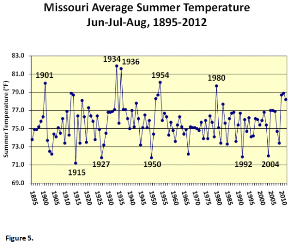
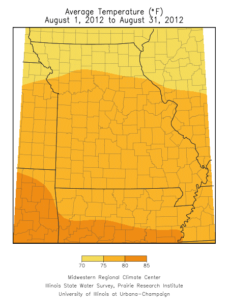
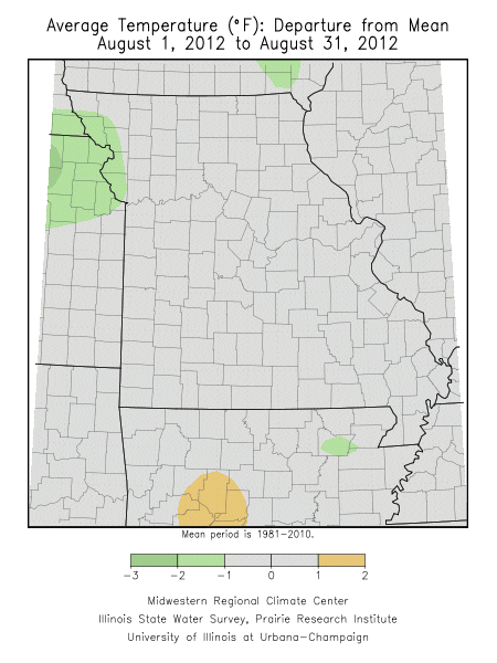
Extreme heat was less frequent and intense during August, compared to the previous two months, and periods of below normal temperatures were also experienced. Preliminary data indicate the statewide average temperature for August was 76.2°F, or 0.1°F above the 30-year normal. It was the 11th consecutive month with above normal temperatures for the state. Preliminary data ranks the summer of 2012 as the 12th hottest June through August period on record (Figure 5.)
Drought impacts persisted and worsened including widespread crop and pasture losses, livestock stress, and declining stock water and hay supplies. Hydrological issues such as dry wells and stream beds, low river levels, and rural and urban water restrictions were commonplace. Barge traffic along the Mississippi was being hindered due to low water levels not seen since 1988. Grassfires were numerous and averaging well above normal. The extreme conditions were adversely affecting gardens, lawns, trees and shrubs with numerous instances of vulnerable species succumbing to water and heat stress. Wildlife was impacted by the lack of healthy vegetation and dwindling water resources.
According to the Missouri Agricultural Statistics Service, by the last week of August, corn, soybean and pastures were reported to be in 85%, 78%, and 99% poor to very poor condition, respectively. Soil moisture reserves were depleted with 96% of the topsoil and subsoil reported in short to very short condition. Hay and stock water supplies were well below normal and reported to be in 90% and 94% short to very short condition, respectively.
The precipitation at the end of the month, compliments of Hurricane Isaac, by no means eliminated the drought condition, but it was a step in the right direction. Complete drought elimination for Missouri will take frequent, widespread and significant precipitation events as we progress into the fall season. A significant deficit has accumulated over the past several months and it will take a substantial amount of water to bring depleted water resources above and below the ground to capacity.
According to the Climate Prediction Center, temperature and precipitation outlooks for the fall season (Sep-Oct-Nov) are calling for above normal temperatures and equal chances for above, below, and near normal precipitation.